 geocat.ch
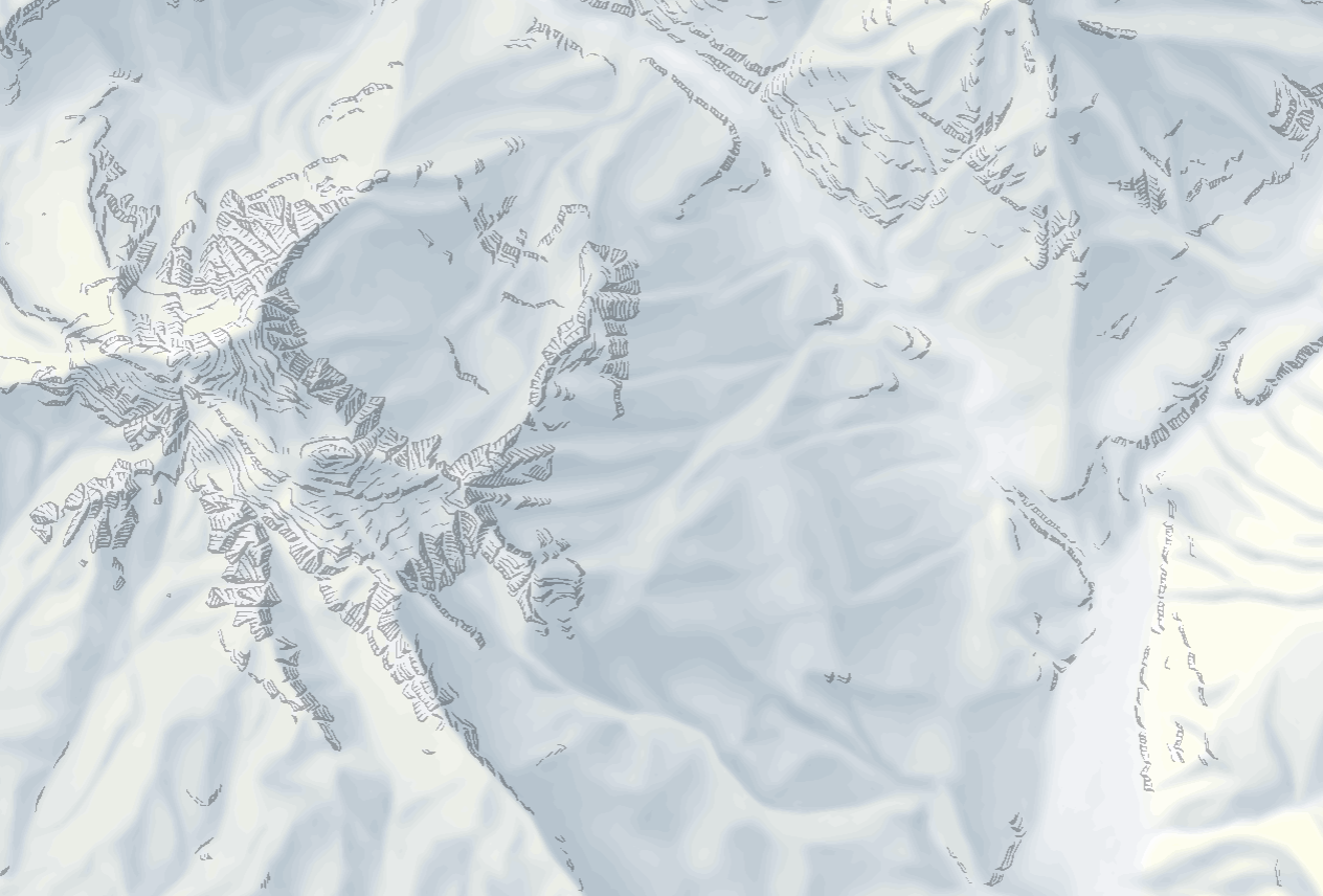
Vektorielles Gelände (Vector Tileset)
Relief vectoriel (Vector Tileset)
Rilievo vettoriale (Vector Tileset)
Vector relief (Vector Tileset)
Aus dem digitalen Höhenmodell swissALTI3D und aus Elementen des digitalen kartografischen Modells abgeleitete Vektor-Darstellung, mit welcher das Relief der Schweiz, des Fürstentums Liechtenstein und des grenznahen Auslands abgebildet werden kann. Sie kombiniert Elemente aus der Landeskarten (das ursprünglich manuell erstellte Relief, den gelben Sonnenton, die Geländedarstellungen Fels, Geröll und Gletscher). Der Inhalt variiert je nach Zoomstufe.
Représentation vectorielle dérivée du modèle altimétrique numérique swissALTI3D et d'éléments du modèle cartographique numérique qui permet de visualiser le relief de la Suisse, de la Principauté de Liechtenstein et des régions étrangères proches de la frontière. Elle combine des éléments tirés des cartes nationales (le relief initialement fait à la main, la coloration jaune, les éléments de terrain des rochers, des éboulis et des glaciers). Le contenu varie selon les niveaux de zoom.
Rappresentazione vettoriale derivata dal modello altimetrico digitale swissALTI3D e da elementi del modello cartografico digitale, con cui è possibile mappare il rilievo della Svizzera, del Principato del Liechtenstein e dei paesi confinanti. Combina elementi delle carte nazionali (il rilievo creato in origine manualmente, la tonalità gialla del sole, le rappresentazioni del terreno con rocce, detriti e ghiacciai). Il contenuto varia a seconda del livello di zoom.
Vector representation derived from the digital elevation model swissALTI3D and from elements of the digital cartographic model, with which the relief of Switzerland, the Principality of Liechtenstein and bordering countries can be depicted. It combines elements from the National Maps (the original hand-made relief, the yellow colouring, the terrain elements of rocks, scree slopes and glaciers). The content varies according to the zoom levels.
Preschentaziun deducida dal model digital da l'autezza swissALTI3D e d'elements dal model cartografic digital, cun la quala po vegnir preschentà il reliev da la Svizra e dal Principadi da Liechtenstein. Ella cumbinescha elements da la chartas naziunalas (il reliev ch'è oriundamain vegnì fatg a maun, il tun mellen dal sulegl, las preschentaziuns da la cuntrada spelm, glera e glatscher). Il cuntegn variescha tut tenor il stgalim da zoom.
Simple
-
Autre titreAltri nomi o acronimiAlternate titleAlternate titleAlternativtitel
-
Gelände Vector Tileset
Relief Vector Tileset
Rilievo Vector Tileset
Relief Vector Tileset
-
Date (Création)Data (Creazione)Date (Creation)Date (Creation)Datum (Erstellung)
- 2023-06-01
-
Date (Révision)Data (Revisione)Date (Revision)Date (Revision)Datum (Aktualisierung)
- 2026-04-01
-
ÉditionEdizioneEditionEditionAusgabe
-
1.0.0
-
IdentifiantIdentificatoreIdentifierIdentifierKennung
- ch.swisstopo.relief.vt
-
ÉtatStatoStatusStatusBearbeitungsstatus
-
ContinuIn corsoOn goingOn goingKontinuierliche Aktualisierung
Point de contact
Punto di contatto
Point of contact
Point of contact
Ansprechpartner
Propriétaire
Proprietario
Owner
Owner
Eigentümer
-
Type de représentation spatialeTipo di rappresentazione spazialeSpatial representation typeSpatial representation typeRäumliche Darstellungsart
-
vecteurVettorialeVectorVectorVektor
Résolution spatiale
Risoluzione spaziale
Spatial resolution
Spatial resolution
Räumliche Auflösung
Fraction représentative
Frazione rappresentativa
Equivalent scale
Equivalent scale
Vergleichsmassstab
-
DénominateurDenominatoreDenominatorDenominatorMassstabszahl
- 5000
Résolution spatiale
Risoluzione spaziale
Spatial resolution
Spatial resolution
Räumliche Auflösung
Fraction représentative
Frazione rappresentativa
Equivalent scale
Equivalent scale
Vergleichsmassstab
-
DénominateurDenominatoreDenominatorDenominatorMassstabszahl
- 1000000
-
Catégorie de thèmeCategoria ISOTopic categoryTopic categoryThematik
-
-
A Imagerie, cartes de base et occupation du solA Mappe di base con immagini della copertura terrestreA Imagery base maps earth coverA Imagery base maps earth coverA Oberflächenbeschreibung
-
Étendue
Estensione
Extent
Extent
Ausdehnung
Étendue
Estensione
Extent
Extent
Ausdehnung
-
DescriptionDescrizioneDescriptionDescriptionBeschreibung
-
National map 1:1'000'000
Landeskarte 1:1'000'000
Carte nationale 1:1'000'000
Carta nazionale 1:1'000'000
Landeskarte 1:1'000'000
-
Identifiant géographiqueIdentificatore geograficoGeographic identifierGeographic identifierGeografische Kennung
- NM1000LK1000CN1000CN1000LK1000
))

-
Fréquence de mise à jourFrequenza di aggiornamentoMaintenance and update frequencyMaintenance and update frequencyWartungsintervall
-
AnnuelleAnnualmenteAnnuallyAnnuallyJährlich
- geocat.ch
-
-
représentation du terrain
rappresentazione del terreno
terrain representation
-
géodonnées de base
geodati di base
official geodata
-
IFDG l’Infrastructure Fédérale de données géographiques
IFDG Infrastruttura federale dei dati geografici
FSDI Federal Spatial Data Infrastructure
-
carte de base
carta di base
base map
-
Contraintes sur la ressource
Vincoli sulle risorse
Resource constraints
Resource constraints
Ressourcenbeschränkungen
-
Contraintes d'utilisationVincoli d'usoUse constraintsUse constraintsNutzungseinschränkungen
-
Autres restrictionsAltre restrizioniOther restrictionsOther restrictionsAndere Beschränkungen
-
Autres contraintesAltri vincoliOther constraintsOther constraintsAndere Einschränkungen
- Opendata BY: Freie Nutzung. Quellenangabe ist Pflicht.Opendata BY: Utilisation libre. Obligation d’indiquer la source.Opendata BY: Libero utilizzo. Indicazione della fonte obbligatoria.Opendata BY: Open use. Must provide the source.
-
Autres contraintesAltri vincoliOther constraintsOther constraintsAndere Einschränkungen
- Allgemeine Nutzungsbedingungen der Bundes Geodaten-Infrastruktur BGDIConditions générales d’utilisation et d’exploitation de l’Infrastructure fédérale de données géographiques IFDGCondizioni generali di utilizzo e disposizioni operative dell’infrastruttura federale di dati geografici (IFDG)General Terms of Use and Operating Conditions of the Federal Spatial Data Infrastructure FSDI
-
LangueLinguaLanguageLanguageSprache
- English
-
Encodage de caractèresCodifica dei caratteriCharacter encodingCharacter encodingZeichenkodierung
-
Utf8UTF8UTF8UTF8Utf8
-
Catégorie de sous-thèmeCategoria di sottotemaSubtopic CategorySubtopic CategoryThematische Unterkategorien
-
A1 Cartes de base, modèles de paysageA1 Mappe di base, modelli paesaggisticiA1 Base Maps, Landscape ModelsA1 Base Maps, Landscape ModelsA1 Basiskarten, Landschaftsmodelle
-
Géodonnées de baseGeodati di baseBasic GeodataBasic GeodataGeobasisdaten
- false
-
Niveau des géodonnées de baseLivello legale dei geodati di baseBasic Geodata Legal LevelBasic Geodata Legal LevelGeobasisdatenebene
-
FédéralFederaleFederalFederalNational
-
Type de géodonnées de baseTipo di geodati di baseBasic Geodata TypeBasic Geodata TypeGeobasisdatentyp
-
Géodonnées de référenceGeodati di riferimentoReference GeodataReference GeodataGeoreferenzdaten
-
Format de distributionFormato (codifica)Distribution formatDistribution formatAbgabeformat
-
-
Mapbox Vector Tiles (MBtiles)
-
Options de transfert numérique
Opzioni di trasferimento digitale
Digital transfer options
Digital transfer options
Optionen für die digitale Übertragung
-
Ressource en ligneRisorsa onlineOnLine resourceOnLine resourceOnline
-
Web Service Beschreibung
Web Service BeschreibungDescription du service webDescrizione del servizio webWeb Service Description
Options de transfert numérique
Opzioni di trasferimento digitale
Digital transfer options
Digital transfer options
Optionen für die digitale Übertragung
-
Ressource en ligneRisorsa onlineOnLine resourceOnLine resourceOnline
-
Vorschau map.geo.admin.ch
-
Nom du système de référenceNome del sistema di riferimentoReference system identifierReference system identifierName des Referenzsystems
- EPSG:3857
Metadata
-
Identifiant des métadonnéesIdentificativo della schedaMetadata identifierMetadata identifierIdentifikator des Metadatensatzes
- 64cc025d-fbab-412f-a31a-adeea889cdc9
-
LangueLinguaLanguageLanguageSprache
- Deutsch
-
Encodage de caractèresCodifica dei caratteriCharacter encodingCharacter encodingZeichenkodierung
-
Utf8UTF8UTF8UTF8Utf8
-
LangueLinguaLanguageLanguageSprache
- Français
-
Encodage de caractèresCodifica dei caratteriCharacter encodingCharacter encodingZeichenkodierung
-
Utf8UTF8UTF8UTF8Utf8
-
LangueLinguaLanguageLanguageSprache
- Italiano
-
Encodage de caractèresCodifica dei caratteriCharacter encodingCharacter encodingZeichenkodierung
-
Utf8UTF8UTF8UTF8Utf8
-
LangueLinguaLanguageLanguageSprache
- English
-
Encodage de caractèresCodifica dei caratteriCharacter encodingCharacter encodingZeichenkodierung
-
Utf8UTF8UTF8UTF8Utf8
-
LangueLinguaLanguageLanguageSprache
- Rumantsch
-
Encodage de caractèresCodifica dei caratteriCharacter encodingCharacter encodingZeichenkodierung
-
Utf8UTF8UTF8UTF8Utf8
Point de contact
Punto di contatto
Point of contact
Point of contact
Ansprechpartner
-
Heures de serviceOrario di servizioHours of serviceHours of serviceBetriebszeiten
-
08h30 - 11h00 / 14h00 - 16h00 GMT+1
Type de ressource
Tipo di risorsa
Type of resource
Type of resource
Anwendungsbereich der Metadaten
-
Domaine d'application de la ressourceAmbito di applicazione della risorsaResource scopeResource scopeDomäne der Ressourcenanwendung
-
Jeu de donnéesSet di datiDatasetDatasetDatenbestand
-
Lien vers la métadonnéeCollegamento ai metadatiMetadata linkageMetadata linkageLink zu den Metadaten
-
Informations de date (Création)Informazioni sulla data (Creazione)Date info (Creation)Date info (Creation)Datumsangaben (Erstellung)
- 2023-06-07T09:10:54.846Z
-
Informations de date (Révision)Informazioni sulla data (Revisione)Date info (Revision)Date info (Revision)Datumsangaben (Aktualisierung)
- 2026-05-08T08:46:46.55875Z
Norme des métadonnées
Standard dei metadati
Metadata standard
Metadata standard
Metadatenstandard
-
TitreTitoloTitleTitleTitel
-
eCH-0271
Overviews
Spatial extent

Provided by
