geocat.ch
SWISSIMAGE (VS)
SWISSIMAGE (VS)
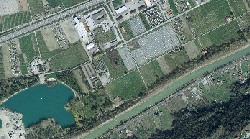
La mosaïque d"orthophotos SWISSIMAGE 10 cm est un assemblage des nouvelles images aériennes numériques en couleurs sur l"ensemble de la Suisse avec une résolution au sol de 10 cm dans les régions de plaine et les principales vallées alpines et de 25 cm dans les Alpes.
SWISSIMAGE est produit en tuiles de 1 km2. La numérotation des tuiles correspond aux coordonnées kilométriques de leur angle sud-ouest. Outre la qualité géométrique et radiométrique, la date de vol des photos aériennes constitue un élément essentiel pour l'utilisation optimale d'une photo. L'année de vol est définie pour chaque tuile produite. Dans les zones situées à la limite entre différents blocs annuels tous les pixels d'une tuile ne proviennent pas toujours d'une seule et même année de vol. En effet, pour créer une mosaïque uniforme, il est parfois nécessaire de mélanger des pixels issus de différents vols. Dans ce cas, l'année de vol utilisée en majorité (à plus de 75%) est attribuée à la tuile.
Das Orthophotomosaik SWISSIMAGE 10 cm ist eine Zusammensetzung der neuen digitalen Farbluftbilder über die ganze Schweiz mit einer Bodenauflösung von 10 cm im Flachland und der wichtigsten Alpentäler sowie 25 cm in den Alpen.
SWISSIMAGE wird in Kacheln von jeweils 1 km2 produziert. Die Kachelnummerierung entspricht den Kilometerkoordinaten des südwestlichen Eckpunkts einer Kachel. Neben der geometrischen und radiometrischen Qualität ist das Flugdatum der Luftbilder für die optimale Benutzung eines Orthophotos von grosser Wichtigkeit. Das Flugjahr wird daher für jede Kachel angegeben. In den Randgebieten der Befliegungsblöcke kann es vorkommen, dass die Kacheln nicht mit Bildern ein und desselben Flugjahres abgedeckt werden können. Diese Kacheln weisen daher Pixel unterschiedlicher Flugjahre auf, wobei jeweils dasjenige Flugjahr attributiert wird,das die Mehrheit der Pixel aufweist (mehr als 75% aller Pixel).
Simple
-
Datum (Erstellung)Data (Creazione)Date (Creation)Date (Creation)Date (Création)
- 2001-01-01
-
Datum (Aktualisierung)Data (Revisione)Date (Revision)Date (Revision)Date (Révision)
- 2024-07-31
-
KennungIdentificatoreIdentifierIdentifierIdentifiant
- 167
-
ZweckScopoPurposePurposeBut
-
fond visuel et données de référence
als Hintergrund und Referenzdaten
-
BearbeitungsstatusStatoStatusStatusÉtat
-
Kontinuierliche AktualisierungIn corsoOn goingOn goingContinu
Verwalter
Custode
Custodian
Custodian
Dépositaire
-
Räumliche DarstellungsartTipo di rappresentazione spazialeSpatial representation typeSpatial representation typeType de représentation spatiale
-
Raster, GitterRasterGridGridgrille
Räumliche Auflösung
Risoluzione spaziale
Spatial resolution
Spatial resolution
Résolution spatiale
-
DistanzDistanza di risoluzioneSpatial resolutionSpatial resolutionDistance de résolution
- 0.1 m
-
ThematikCategoria ISOTopic categoryTopic categoryCatégorie de thème
-
-
A OberflächenbeschreibungA Mappe di base con immagini della copertura terrestreA Imagery base maps earth coverA Imagery base maps earth coverA Imagerie, cartes de base et occupation du sol
-
Ausdehnung
Estensione
Extent
Extent
Étendue
Ausdehnung
Estensione
Extent
Extent
Étendue
-
BeschreibungDescrizioneDescriptionDescriptionDescription
-
Canton of Valais (VS)
Kanton Wallis (VS)
Canton du Valais (VS)
Cantone Vallese (VS)
Chantun Vallais (VS)
))

-
WartungsintervallFrequenza di aggiornamentoMaintenance and update frequencyMaintenance and update frequencyFréquence de mise à jour
-
userDefineduserDefineduserDefineduserDefineduserDefined
-
AnmerkungNota sull'aggiornamentoMaintenance noteMaintenance noteRemarque sur la mise à jour
-
La mise à jour s’effectue par secteur suivant un cycle de 3 ans.
Die Nachführung erfolgt mit einem Nachführungszyklus von 3 Jahren.
Format der Ressource
Formato della risorsa
Resource format
Resource format
Format de la ressource
-
TitelTitoloTitleTitleTitre
-
ESRI Enterprise Geodatabase
-
DatumDataDateDateDate
- GEMET
-
-
Luftbild
fotografia aerea (immagine)
aerial photograph
-
- geocat.ch
-
-
Digitales Farborthofotomosaik
mosaico di ortofoto digitali a colori
digital color orthophoto mosaic
-
Orthofoto
ortofoto
orthophoto
-
Geobasisdaten
geodati di base
official geodata
-
Ressourcenbeschränkungen
Vincoli sulle risorse
Resource constraints
Resource constraints
Contraintes sur la ressource
-
NutzungsbeschränkungLimitazione d'usoUse limitationUse limitationLimitation d'utilisation
-
sous licence
Lizenzbedingungen
Ressourcenbeschränkungen
Vincoli sulle risorse
Resource constraints
Resource constraints
Contraintes sur la ressource
-
ZugriffsbeschränkungenVincoli di accessoAccess constraintsAccess constraintsContraintes d'accès
-
Andere BeschränkungenAltre restrizioniOther restrictionsOther restrictionsAutres restrictions
-
Andere EinschränkungenAltri vincoliOther constraintsOther constraintsAutres contraintes
-
Géodonnées accessibles au public (niveau A selon l'OGéo)
Die Geodaten sind öffentlich zugänglich. (Zugangsberechtigungsstufe A nach KGeoIG)
-
Andere EinschränkungenAltri vincoliOther constraintsOther constraintsAutres contraintes
-
Les conditions générales d'utilisation des géodonnées du Canton du Valais font foi ( https://www.vs.ch/fr/web/guest/information-legale).
Es gelten die Nutzungsbedingungen für Geodaten des Kantons Wallis ( https://www.vs.ch/de/web/guest/rechtliches).
-
SpracheLinguaLanguageLanguageLangue
- Français
-
ZeichenkodierungCodifica dei caratteriCharacter encodingCharacter encodingEncodage de caractères
-
Utf8UTF8UTF8UTF8Utf8
-
SpracheLinguaLanguageLanguageLangue
- Deutsch
-
ZeichenkodierungCodifica dei caratteriCharacter encodingCharacter encodingEncodage de caractères
-
Utf8UTF8UTF8UTF8Utf8
-
Beschreibung der ArbeitsumgebungDescrizione dell'ambiente di lavoroEnvironment descriptionEnvironment descriptionDescription de l'environnement de travail
-
S:\Géodonnées VS\A3 Images\SwissImage.lyr, S:\Géodonnées VS\A3 Images\SwissImage Index.lyr
S:\Geodaten VS\A3 Luft-, Satellitenbilder\Swissimage.lyr, S:\Geodaten VS\A3 Luft-, Satellitenbilder\SwissImage Index.lyr
-
Zusätzliche InformationenInformazioni supplementariSupplemental InformationSupplemental InformationInformations supplémentaires
-
Etat des mises à jour S:\Géodonnées VS\A3 Images\SwissImage Index.lyr
Nachführungsstand: S:\Geodaten VS\A3 Luft-, Satellitenbilder\SwissImage Index.lyr
-
Thematische UnterkategorienCategoria di sottotemaSubtopic CategorySubtopic CategoryCatégorie de sous-thème
-
A1 Basiskarten, LandschaftsmodelleA1 Mappe di base, modelli paesaggisticiA1 Base Maps, Landscape ModelsA1 Base Maps, Landscape ModelsA1 Cartes de base, modèles de paysage
-
Thematische UnterkategorienCategoria di sottotemaSubtopic CategorySubtopic CategoryCatégorie de sous-thème
-
A3 Luft-, SatellitenbilderA3 Immagini aeree e satellitariA3 Aerial and Satellite ImageryA3 Aerial and Satellite ImageryA3 Images aériennes, satellites
-
GeobasisdatenGeodati di baseBasic GeodataBasic GeodataGéodonnées de base
- true
-
Identifikator des GeobasisdatensatzesIdentificativo dei geodati di baseBasic Geodata IDBasic Geodata IDIdentifiant Géodonnées de base
-
35.1
-
GeobasisdatenebeneLivello legale dei geodati di baseBasic Geodata Legal LevelBasic Geodata Legal LevelNiveau des géodonnées de base
-
NationalFederaleFederalFederalFédéral
-
GeobasisdatentypTipo di geodati di baseBasic Geodata TypeBasic Geodata TypeType de géodonnées de base
-
GeoreferenzdatenGeodati di riferimentoReference GeodataReference GeodataGéodonnées de référence
-
AbgabeformatFormato (codifica)Distribution formatDistribution formatFormat de distribution
-
-
GeoTIFF (GEOTIFF)
-
Cloud Optimized GeoTIFF (TIFF / TIF)
-
Verteiler
Distributore
Distributor
Distributor
Distributeur
-
ErklärungInformazioni generali sulla provenienzaStatementStatementGénéralités sur la provenance
-
Se base sur les images aériennes
basiert auf den Luftbildern
-
BezugsebeneLivelloHierarchy levelHierarchy levelNiveau
-
DatenbestandSet di datiDatasetDatasetJeu de données
-
QuelleFonteSourceSourceSource
-
Name des ReferenzsystemsNome del sistema di riferimentoReference system identifierReference system identifierNom du système de référence
- EPSG:2056/CH1903+_MN95
Metadata
-
Identifikator des MetadatensatzesIdentificativo della schedaMetadata identifierMetadata identifierIdentifiant des métadonnées
- 62ddd584-fc70-4899-941c-e59129bc650b
-
SpracheLinguaLanguageLanguageLangue
- Français
-
ZeichenkodierungCodifica dei caratteriCharacter encodingCharacter encodingEncodage de caractères
-
Utf8UTF8UTF8UTF8Utf8
-
SpracheLinguaLanguageLanguageLangue
- Deutsch
-
ZeichenkodierungCodifica dei caratteriCharacter encodingCharacter encodingEncodage de caractères
-
Utf8UTF8UTF8UTF8Utf8
-
SpracheLinguaLanguageLanguageLangue
- Italiano
-
ZeichenkodierungCodifica dei caratteriCharacter encodingCharacter encodingEncodage de caractères
-
Utf8UTF8UTF8UTF8Utf8
-
SpracheLinguaLanguageLanguageLangue
- English
-
ZeichenkodierungCodifica dei caratteriCharacter encodingCharacter encodingEncodage de caractères
-
Utf8UTF8UTF8UTF8Utf8
-
SpracheLinguaLanguageLanguageLangue
- Rumantsch
-
ZeichenkodierungCodifica dei caratteriCharacter encodingCharacter encodingEncodage de caractères
-
Utf8UTF8UTF8UTF8Utf8
Verteiler
Distributore
Distributor
Distributor
Distributeur
Anwendungsbereich der Metadaten
Tipo di risorsa
Type of resource
Type of resource
Type de ressource
-
Domäne der RessourcenanwendungAmbito di applicazione della risorsaResource scopeResource scopeDomaine d'application de la ressource
-
DatenbestandSet di datiDatasetDatasetJeu de données
-
Link zu den MetadatenCollegamento ai metadatiMetadata linkageMetadata linkageLien vers la métadonnée
-
Datumsangaben (Erstellung)Informazioni sulla data (Creazione)Date info (Creation)Date info (Creation)Informations de date (Création)
- 2014-12-16T18:02:46Z
-
Datumsangaben (Aktualisierung)Informazioni sulla data (Revisione)Date info (Revision)Date info (Revision)Informations de date (Révision)
- 2026-05-18T11:52:25.986276Z
Metadatenstandard
Standard dei metadati
Metadata standard
Metadata standard
Norme des métadonnées
-
TitelTitoloTitleTitleTitre
-
eCH-0271