 geocat.ch
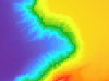
Bathymetrie Thunersee
Hochaufgelöste Vermessung des Seegrundes des Thunersees mit Multibeam-Echolot und LIDAR. Aus diesen Daten wurde ein digitales Höhenmodell des Seegrundes (1x1m-Raster) generiert.
Simple
- Date (Creation)
- 2020-01-01
- Date (Revision)
- 2020-01-01
- Date (Publication)
- 2024-03-07
- Identifier
- BATHYTHU
- Status
- Completed
Owner
Principal investigator
Principal investigator
Principal investigator
- Topic category
-
- C Elevation
Extent
Extent
- Description
- Kanton Bern (reduziert) Canton de Berne (réduit)
))
- Maintenance and update frequency
- Not planned
- Keywords
-
-
Unterwassermorphologie
-
opendata.swiss
-
Resource constraints
- Use limitation
-
Auf sämtlichen Plots und Publikationen ist der Vermerk "Bathymetrie Thunersee © Amt für Landwirtschaft und Natur des Kantons Bern, Amt für Wasser und Abfall des Kantons Bern" anzugeben.
Resource constraints
- Use constraints
- Licence End User
- Other constraints
- Die Daten dürfen gemäss Nutzungsbedingungen frei genutzt werden. Les données peuvent être utilisées librement selon les conditions d’utilisation.
Resource constraints
- Other constraints
- Freie Nutzung. Quellenangabe ist Pflicht. Utilisation libre. Obligation d’indiquer la source.
- Language
- Deutsch
- Character encoding
- UTF8
- Language
- Français
- Character encoding
- UTF8
- Language
- Italiano
- Character encoding
- UTF8
- Language
- English
- Character encoding
- UTF8
- Basic Geodata
- true
- Basic Geodata ID
-
104-BE
- Basic Geodata Legal Level
- Cantonal
- Included with dataset
- false
- Distribution format
-
-
SHP
-
GPKG
-
GeoParquet
-
Digital transfer options
- Transfer size
- 396168624
- OnLine resource
-
ZIP-Datei mit Shapefile, Esri Grid, Metadaten und Begleitdaten
Digital transfer options
- Transfer size
- 91888073
- OnLine resource
-
ZIP-Datei mit Geopackage mit Metadaten
Digital transfer options
- Transfer size
- 197512284
- OnLine resource
-
Cloud-optimierte GeoTiff-Datei - Höhenmodell Seegrund Thunersee
Digital transfer options
- Transfer size
- 46089714
- OnLine resource
-
Cloud-optimierte GeoTiff-Datei - Relief Seegrund Thunersee
Digital transfer options
- Transfer size
- 107248951
- OnLine resource
-
Geoparquet-Datei - Isobathen Thunersee
Digital transfer options
- Transfer size
- 196958150
- OnLine resource
-
Cloud-optimierte GeoTiff-Datei - Wassertiefe Thunersee
Digital transfer options
- OnLine resource
-
STAC-Collection - BATHYTHU
Digital transfer options
- OnLine resource
-
Link zum Geoportal des Kantons Bern
- Reference system identifier
- CH1903+ / LV95 -- Swiss CH1903+ / LV95/EPSG:2056
Metadata
- Metadata identifier
- 6025c6f2-639b-475e-ae15-676260397b53
- Language
- Deutsch
- Character encoding
- UTF8
- Language
- Français
- Character encoding
- UTF8
Point of contact
Type of resource
- Resource scope
- Dataset
- Name
-
Geoprodukt - Géoproduit
- Date info (Creation)
- 2020-01-01T00:00:00Z
- Date info (Revision)
- 2024-03-07T00:00:00Z
Metadata standard
- Title
-
GM03 2+
)))