geocat.ch
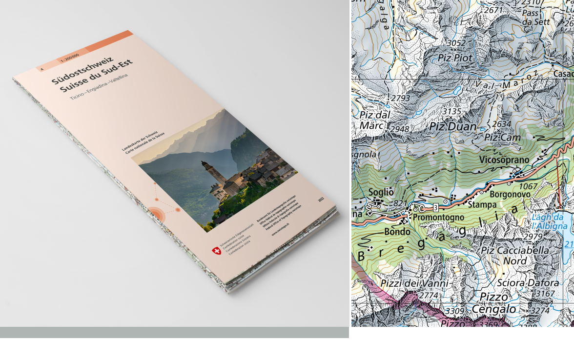
National Map 1:200'000
The National Map 1:200,000 is a topographic map giving an overview of Switzerland. The map perimeter is divided into 4 (printed map) or 16 (Swiss Map Raster) sheets. The National Map 1:200,000 is published in analogue format as a printed map and in digital format as a Swiss Map Raster. The update is done by sector. The different statuses of updates are shown in the layer "<a href=" https://map.geo.admin.ch/?lang=en&topic=ech&bgLayer=ch.swisstopo.pixelkarte-farbe&layers=ch.swisstopo.pixelkarte-pk200.metadata" target="_blank">Division national map 200 Raster</a> ".
Simple
- Alternate title
-
National Map 1:200'000
- Date (Creation)
- 1971-06-30
- Date (Revision)
- 2026-01-01
- Identifier
- ch.swisstopo.pixelkarte-farbe-pk200.noscale
- Presentation form
- Hardcopy map
- Presentation form
- Digital map
- Purpose
-
Georeferenzdaten des Bundesrechts
- Status
- On going
Point of contact
Owner
- Spatial representation type
- paperMap
- Spatial representation type
- Grid
Spatial resolution
Equivalent scale
- Denominator
- 200000
- Topic category
-
- A Imagery base maps earth cover
Extent
Extent
- Description
-
National map 1:200'000
- Geographic identifier
- NM200
))

- Maintenance and update frequency
- Irregular
- Duration of Conservation
- 275
- Appraisal of Archival Value
- A
- Reason for Archiving Value
- Evidence of business practice
- geocat.ch
-
-
Conservation and archiving planning AAP - Confederation
-
official geodata
-
national map
-
terrain representation
-
opendata.swiss
-
traffic network
-
- GEMET
-
-
relief (land)
-
water (geographic)
-
border
-
cartography
-
- GEMET - INSPIRE themes, version 1.0
-
-
Geographical names
-
- geocat.ch
-
-
FSDI Federal Spatial Data Infrastructure
-
- geocat.ch
-
-
topography
-
- GEMET
-
-
map chart
-
Resource constraints
- Other constraints
- Opendata BY: Open use. Must provide the source.
Associated resource
- Title
-
Landeskartenwerk 1:25'000 bis 1:1 Mio.
- Association Type
- Reference to a master resource of which this one is a part
- Language
- Deutsch
- Character encoding
- UTF8
- Language
- Français
- Character encoding
- UTF8
- Language
- Italiano
- Character encoding
- UTF8
- Language
- Rumantsch
- Character encoding
- UTF8
- Subtopic Category
- A1 Base Maps, Landscape Models
- Basic Geodata
- true
- Basic Geodata ID
-
42.4
- Basic Geodata Legal Level
- Federal
- Basic Geodata Type
- Reference Geodata
- Distribution format
-
-
Cloud Optimized GeoTIFF (TIFF / TIF)
-
analog
-
Point of contact
- Hours of service
-
07h45 - 11h45 / 13h30 - 17h00
Point of contact
Digital transfer options
- OnLine resource
-
Vorschau map.geo.admin.ch
Preview map.geo.admin.ch
Digital transfer options
- OnLine resource
-
ch.swisstopo.pixelkarte-farbe-pk200.noscale
WMS-FSDI service, layer "National Map 1:200`000"
Digital transfer options
- OnLine resource
-
ch.swisstopo.pixelkarte-farbe-pk200.noscale
WMTS-FSDI service, layer "National Map 1:200'000"
Digital transfer options
Digital transfer options
- Statement
-
Based on the topographic survey
- Hierarchy level
- Dataset
- Reference system identifier
- CH1903
Metadata
- Metadata identifier
- 5f75341e-2050-4ed9-a8de-ee7637490565
- Language
- Deutsch
- Character encoding
- UTF8
- Language
- Français
- Character encoding
- UTF8
- Language
- Italiano
- Character encoding
- UTF8
- Language
- English
- Character encoding
- UTF8
- Language
- Rumantsch
- Character encoding
- UTF8
Point of contact
Type of resource
- Resource scope
- Dataset
- Metadata linkage
-
https://www.geocat.ch/geonetwork/srv/api/records/5f75341e-2050-4ed9-a8de-ee7637490565
- Date info (Creation)
- 2009-04-02T12:00:00Z
- Date info (Revision)
- 2026-04-13T09:16:19.163495Z
Metadata standard
- Title
-
eCH-0271