geocat.ch
Landeskarte 1:200'000
Carte nationale 1:200'000
Carta nazionale 1:200'000
National Map 1:200'000
Charta naziunala 1:200'000
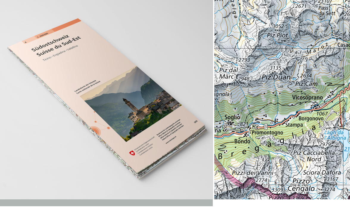
Die Landeskarte 1:200'000 ist eine topografische Übersichtskarte der Schweiz. Der Kartenperimeter ist in 4 (Papierkarte), bzw. 16 (Swiss Map Raster) Kartenblätter aufgeteilt. Die Landeskarte 1:200'000 ist in analoger (Papierkarte) und in digitaler (Swiss Map Raster) Form verfügbar. Die Nachführung erfolgt sektorenweise. Die verschiedenen Nachführungsstände zeigt der Layer "<a href=" https://map.geo.admin.ch/?lang=de&topic=ech&bgLayer=ch.swisstopo.pixelkarte-farbe&layers=ch.swisstopo.pixelkarte-pk200.metadata" target="_blank">Einteilung Landeskarte 200 Raster</a> ".
La carte nationale au 1:200'000 est une carte topographique synoptique précise de la Suisse. Le périmètre total est divisé en 4 (carte papier) or 16 (Swiss Map Raster) feuilles. La carte nationale au 1:200'000 est disponible sous forme analogique (carte papier) et digitale (Swiss Map Raster). La mise à jour s’effectue par secteur. Les différents états de mise à jour sont indiqués dans la couche "<a href=" https://map.geo.admin.ch/?lang=fr&topic=ech&bgLayer=ch.swisstopo.pixelkarte-farbe&layers=ch.swisstopo.pixelkarte-pk200.metadata" target="_blank">Découpage carte nationale 200 Raster</a> ".
La Carta nazionale 1:200'000 è una carta sinottica topografica della Svizzera. Il perimetro della carta è suddiviso in 4 (cartaceo) o 16 (Swiss Map Raster) fogli. La Carta nazionale 1:200'000 è disponibile in formato analogico (cartaceo) e digitale (Swiss Map Raster). La carta è aggiornata per settori. I diversi stati di aggiornamento sono mostrati nel layer "<a href=" https://map.geo.admin.ch/?lang=it&topic=ech&bgLayer=ch.swisstopo.pixelkarte-farbe&layers=ch.swisstopo.pixelkarte-pk200.metadata" target="_blank">Divisione carta nazionale 200 Raster</a> ".
The National Map 1:200,000 is a topographic map giving an overview of Switzerland. The map perimeter is divided into 4 (printed map) or 16 (Swiss Map Raster) sheets. The National Map 1:200,000 is published in analogue format as a printed map and in digital format as a Swiss Map Raster. The update is done by sector. The different statuses of updates are shown in the layer "<a href=" https://map.geo.admin.ch/?lang=en&topic=ech&bgLayer=ch.swisstopo.pixelkarte-farbe&layers=ch.swisstopo.pixelkarte-pk200.metadata" target="_blank">Division national map 200 Raster</a> ".
La Charta naziunala 1:200'000 è ina charta da survista topografica da la Svizra. Il perimeter da la charta è dividì en 4 (charta da palpiri) u 16 (Swiss Map Raster) fegls singuls. La Charta naziunala 1:200'000 è disponibla en furma analoga (charta da palpiri) e digitala (Swiss Map Raster). L'actualisaziun vegn fatga tenor secturs. Die verschiedenen Nachführungsstände zeigt der Layer "<a href=" https://map.geo.admin.ch/?lang=rm&topic=ech&bgLayer=ch.swisstopo.pixelkarte-farbe&layers=ch.swisstopo.pixelkarte-pk200.metadata" target="_blank">Div. Charta naziunala 200 Raster</a> ".
Simple
-
Autre titreAltri nomi o acronimiAlternate titleAlternate titleAlternativtitel
-
Landeskarte 1:200'000 | LK200
Carte nationale 1:200'000 | CN200
Carta nazionale 1:200'000 | CN200
National Map 1:200'000
Charta naziunala 1:200'000 | CN200
-
Date (Création)Data (Creazione)Date (Creation)Date (Creation)Datum (Erstellung)
- 1971-06-30
-
Date (Révision)Data (Revisione)Date (Revision)Date (Revision)Datum (Aktualisierung)
- 2026-01-01
-
IdentifiantIdentificatoreIdentifierIdentifierKennung
- ch.swisstopo.pixelkarte-farbe-pk200.noscale
-
Forme de la présentationForma della presentazionePresentation formPresentation formPräsentationsform
-
Carte papierMappa cartaceaHardcopy mapHardcopy mapPapierkarte
-
Forme de la présentationForma della presentazionePresentation formPresentation formPräsentationsform
-
Carte numériqueMappa digitaleDigital mapDigital mapDigitale Karte
-
ButScopoPurposePurposeZweck
-
Georeferenzdaten des Bundesrechts
Géodonnées de référence relevant du droit fédéral
Geodati di riferimento del diritto federale
-
ÉtatStatoStatusStatusBearbeitungsstatus
-
ContinuIn corsoOn goingOn goingKontinuierliche Aktualisierung
Point de contact
Punto di contatto
Point of contact
Point of contact
Ansprechpartner
Propriétaire
Proprietario
Owner
Owner
Eigentümer
-
Type de représentation spatialeTipo di rappresentazione spazialeSpatial representation typeSpatial representation typeRäumliche Darstellungsart
-
paperMappaperMappaperMappaperMappaperMap
-
Type de représentation spatialeTipo di rappresentazione spazialeSpatial representation typeSpatial representation typeRäumliche Darstellungsart
-
grilleRasterGridGridRaster, Gitter
Résolution spatiale
Risoluzione spaziale
Spatial resolution
Spatial resolution
Räumliche Auflösung
Fraction représentative
Frazione rappresentativa
Equivalent scale
Equivalent scale
Vergleichsmassstab
-
DénominateurDenominatoreDenominatorDenominatorMassstabszahl
- 200000
-
Catégorie de thèmeCategoria ISOTopic categoryTopic categoryThematik
-
-
A Imagerie, cartes de base et occupation du solA Mappe di base con immagini della copertura terrestreA Imagery base maps earth coverA Imagery base maps earth coverA Oberflächenbeschreibung
-
Étendue
Estensione
Extent
Extent
Ausdehnung
Étendue
Estensione
Extent
Extent
Ausdehnung
-
DescriptionDescrizioneDescriptionDescriptionBeschreibung
-
National map 1:200'000
Landeskarte 1:200'000
Carte nationale 1:200'000
Carta nazionale 1:200'000
Landeskarte 1:200'000
-
Identifiant géographiqueIdentificatore geograficoGeographic identifierGeographic identifierGeografische Kennung
- NM200LK200CN200CN200LK200
))

-
Fréquence de mise à jourFrequenza di aggiornamentoMaintenance and update frequencyMaintenance and update frequencyWartungsintervall
-
IrrégulièreIrregolareIrregularIrregularUnregelmässig
-
Durée de conservationDurata di conservazioneDuration of ConservationDuration of ConservationAufbewahrungsdauer NV in Jahren
- 275
-
Évaluation de la valeur archivistiqueValutazione del valore archivisticoAppraisal of Archival ValueAppraisal of Archival ValueBewertung Archivwürdigkeit
-
AAAAA
-
Raison de la valeur d'archivageMotivo del valore archivisticoReason for Archiving ValueReason for Archiving ValueBegründung Archivwürdigkeit
-
Preuve de la pratique couranteProva della pratica commercialeEvidence of business practiceEvidence of business practiceNachweis der Geschäftspraxis
- geocat.ch
-
-
Planification de la conservation et de l'archivage AAP - Conféderation
Pianificazione della conservazione e dell’archiviazione AAP - Confederazione
Conservation and archiving planning AAP - Confederation
-
géodonnées de base
geodati di base
official geodata
-
carte nationale
carta nazionale
national map
-
représentation du terrain
rappresentazione del terreno
terrain representation
-
opendata.swiss
opendata.swiss
opendata.swiss
opendata.swiss
-
réseau de transport
rete di trasporto
traffic network
-
- GEMET
-
-
relief
rilievo
relief (land)
-
eaux (géographie)
acque (geografia)
water (geographic)
-
bordure
frontiera
border
-
cartographie
cartografia
cartography
-
- GEMET - INSPIRE themes, version 1.0
-
-
Dénominations géographiques
Nomi geografici
Geographical names
-
- geocat.ch
-
-
BGDI Bundesgeodaten-Infrastruktur
IFDG l’Infrastructure Fédérale de données géographiques
IFDG Infrastruttura federale dei dati geografici
FSDI Federal Spatial Data Infrastructure
-
- geocat.ch
-
-
Topografie
topographie
topografia
topography
-
- GEMET
-
-
Karte
cartogramme
mappa
map chart
-
Contraintes sur la ressource
Vincoli sulle risorse
Resource constraints
Resource constraints
Ressourcenbeschränkungen
-
Autres contraintesAltri vincoliOther constraintsOther constraintsAndere Einschränkungen
- Opendata BY: Freie Nutzung. Quellenangabe ist Pflicht.Opendata BY: Utilisation libre. Obligation d’indiquer la source.Opendata BY: Libero utilizzo. Indicazione della fonte obbligatoria.Opendata BY: Open use. Must provide the source.
Ressource associée
Risorsa associata
Associated resource
Associated resource
Verlinkte Ressource
-
TitreTitoloTitleTitleTitel
-
Landeskartenwerk 1:25'000 bis 1:1 Mio.
Cartes nationales du 1:25'000 au 1:1'000'000
Carte nazionali 1:25'000 – 1:1 mio.
-
Type d'associationTipo di associazioneAssociation TypeAssociation TypeAssoziationstyp
-
Citation de travail plus largeCitazione di un'opera più ampiaReference to a master resource of which this one is a partReference to a master resource of which this one is a partÜbergeordneter Datenbestand
-
LangueLinguaLanguageLanguageSprache
- Deutsch
-
Encodage de caractèresCodifica dei caratteriCharacter encodingCharacter encodingZeichenkodierung
-
Utf8UTF8UTF8UTF8Utf8
-
LangueLinguaLanguageLanguageSprache
- Français
-
Encodage de caractèresCodifica dei caratteriCharacter encodingCharacter encodingZeichenkodierung
-
Utf8UTF8UTF8UTF8Utf8
-
LangueLinguaLanguageLanguageSprache
- Italiano
-
Encodage de caractèresCodifica dei caratteriCharacter encodingCharacter encodingZeichenkodierung
-
Utf8UTF8UTF8UTF8Utf8
-
LangueLinguaLanguageLanguageSprache
- Rumantsch
-
Encodage de caractèresCodifica dei caratteriCharacter encodingCharacter encodingZeichenkodierung
-
Utf8UTF8UTF8UTF8Utf8
-
Catégorie de sous-thèmeCategoria di sottotemaSubtopic CategorySubtopic CategoryThematische Unterkategorien
-
A1 Cartes de base, modèles de paysageA1 Mappe di base, modelli paesaggisticiA1 Base Maps, Landscape ModelsA1 Base Maps, Landscape ModelsA1 Basiskarten, Landschaftsmodelle
-
Géodonnées de baseGeodati di baseBasic GeodataBasic GeodataGeobasisdaten
- true
-
Identifiant Géodonnées de baseIdentificativo dei geodati di baseBasic Geodata IDBasic Geodata IDIdentifikator des Geobasisdatensatzes
-
42.4
-
Niveau des géodonnées de baseLivello legale dei geodati di baseBasic Geodata Legal LevelBasic Geodata Legal LevelGeobasisdatenebene
-
FédéralFederaleFederalFederalNational
-
Type de géodonnées de baseTipo di geodati di baseBasic Geodata TypeBasic Geodata TypeGeobasisdatentyp
-
Géodonnées de référenceGeodati di riferimentoReference GeodataReference GeodataGeoreferenzdaten
-
Format de distributionFormato (codifica)Distribution formatDistribution formatAbgabeformat
-
-
Cloud Optimized GeoTIFF (TIFF / TIF)
-
analog
-
Point de contact
Punto di contatto
Point of contact
Point of contact
Ansprechpartner
-
Heures de serviceOrario di servizioHours of serviceHours of serviceBetriebszeiten
-
07h45 - 11h45 / 13h30 - 17h00
Point de contact
Punto di contatto
Point of contact
Point of contact
Ansprechpartner
Options de transfert numérique
Opzioni di trasferimento digitale
Digital transfer options
Digital transfer options
Optionen für die digitale Übertragung
-
Ressource en ligneRisorsa onlineOnLine resourceOnLine resourceOnline
-
Vorschau map.geo.admin.ch
Vorschau map.geo.admin.chAperçu map.geo.admin.chPrevisione map.geo.admin.chPreview map.geo.admin.ch
Options de transfert numérique
Opzioni di trasferimento digitale
Digital transfer options
Digital transfer options
Optionen für die digitale Übertragung
-
Ressource en ligneRisorsa onlineOnLine resourceOnLine resourceOnline
-
ch.swisstopo.pixelkarte-farbe-pk200.noscale
WMS-BGDI Dienst, Layer "Landeskarte 1:200`000 | LK200"Service WMS-IFDG, couche "Carte nationale 1:200`000 | CN200"Servizio WMS-IFDG, strato "Carta nazionale 1:200`000 | CN200"WMS-FSDI service, layer "National Map 1:200`000"WMS-BGDI Dienst, Layer "Landeskarte 1:200`000 | LK200"
Options de transfert numérique
Opzioni di trasferimento digitale
Digital transfer options
Digital transfer options
Optionen für die digitale Übertragung
-
Ressource en ligneRisorsa onlineOnLine resourceOnLine resourceOnline
-
ch.swisstopo.pixelkarte-farbe-pk200.noscale
WMTS-BGDI Dienst, Layer "Landeskarte 1:200'000 | LK200"Service WMTS-IFDG, couche , Layer "Carte nationale 1:200'000 | CN200"Servizio WMTS-IFDG, strato "Carta nazionale 1:200'000 | CN200"WMTS-FSDI service, layer "National Map 1:200'000"WMTS-BGDI Dienst, Layer "Landeskarte 1:200'000 | LK200"
Options de transfert numérique
Opzioni di trasferimento digitale
Digital transfer options
Digital transfer options
Optionen für die digitale Übertragung
Options de transfert numérique
Opzioni di trasferimento digitale
Digital transfer options
Digital transfer options
Optionen für die digitale Übertragung
Options de transfert numérique
Opzioni di trasferimento digitale
Digital transfer options
Digital transfer options
Optionen für die digitale Übertragung
-
Généralités sur la provenanceInformazioni generali sulla provenienzaStatementStatementErklärung
-
Basiert auf der Landesvermessung
Se base sur la Mensuration
Based on the topographic survey
-
NiveauLivelloHierarchy levelHierarchy levelBezugsebene
-
Jeu de donnéesSet di datiDatasetDatasetDatenbestand
-
Nom du système de référenceNome del sistema di riferimentoReference system identifierReference system identifierName des Referenzsystems
- CH1903
Metadata
-
Identifiant des métadonnéesIdentificativo della schedaMetadata identifierMetadata identifierIdentifikator des Metadatensatzes
- 5f75341e-2050-4ed9-a8de-ee7637490565
-
LangueLinguaLanguageLanguageSprache
- Deutsch
-
Encodage de caractèresCodifica dei caratteriCharacter encodingCharacter encodingZeichenkodierung
-
Utf8UTF8UTF8UTF8Utf8
-
LangueLinguaLanguageLanguageSprache
- Français
-
Encodage de caractèresCodifica dei caratteriCharacter encodingCharacter encodingZeichenkodierung
-
Utf8UTF8UTF8UTF8Utf8
-
LangueLinguaLanguageLanguageSprache
- Italiano
-
Encodage de caractèresCodifica dei caratteriCharacter encodingCharacter encodingZeichenkodierung
-
Utf8UTF8UTF8UTF8Utf8
-
LangueLinguaLanguageLanguageSprache
- English
-
Encodage de caractèresCodifica dei caratteriCharacter encodingCharacter encodingZeichenkodierung
-
Utf8UTF8UTF8UTF8Utf8
-
LangueLinguaLanguageLanguageSprache
- Rumantsch
-
Encodage de caractèresCodifica dei caratteriCharacter encodingCharacter encodingZeichenkodierung
-
Utf8UTF8UTF8UTF8Utf8
Point de contact
Punto di contatto
Point of contact
Point of contact
Ansprechpartner
-
Heures de serviceOrario di servizioHours of serviceHours of serviceBetriebszeiten
-
08h30 - 11h00 / 14h00 - 16h00 GMT+1
Type de ressource
Tipo di risorsa
Type of resource
Type of resource
Anwendungsbereich der Metadaten
-
Domaine d'application de la ressourceAmbito di applicazione della risorsaResource scopeResource scopeDomäne der Ressourcenanwendung
-
Jeu de donnéesSet di datiDatasetDatasetDatenbestand
-
Lien vers la métadonnéeCollegamento ai metadatiMetadata linkageMetadata linkageLink zu den Metadaten
-
Informations de date (Création)Informazioni sulla data (Creazione)Date info (Creation)Date info (Creation)Datumsangaben (Erstellung)
- 2009-04-02T12:00:00Z
-
Informations de date (Révision)Informazioni sulla data (Revisione)Date info (Revision)Date info (Revision)Datumsangaben (Aktualisierung)
- 2026-04-13T09:16:19.163495Z
Norme des métadonnées
Standard dei metadati
Metadata standard
Metadata standard
Metadatenstandard
-
TitreTitoloTitleTitleTitel
-
eCH-0271