geocat.ch
Gesamtverkehrsmodell (GVM)
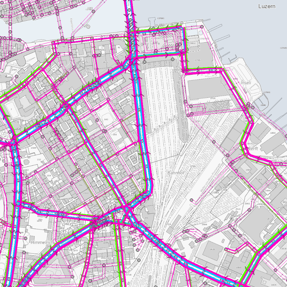
Das Gesamtverkehrsmodell (GVM) zeigt die Belastungen einzelner Strassenabschnitte für verschiedene Tageszeiten. Es beinhaltet sowohl den erhobenen Ist- Zustand von 2017 als auch den prognostizierten Zustand von 2040.
Simple
Informazioni di identificazione
- Titolo alternativo
-
GVMODXXX_COL
- Data (Creazione)
- 2022-06-27
- Formato di presentazione
- Mappa digitale
- Finalità
-
Das Gesamtverkehrsmodell zeigt die Belastungen einzelner Strassenabschnitte für verschiedene Tageszeiten für den Ist- Zustand von 2017 als auch den prognostizierten Zustand von 2040. Die Strassenabschnitte werden über Knoten verbunden. Somit kann eine richtungsabhängige Aussage gemacht werden. Das Gesamtverkehrsmodell bildet eine wichtige Entscheidungsgrundlage für die Raum- und Verkehrsplanung. Mögliche Einsatzbereiche liegen in den Ausbaumöglichkeiten von National- und Kantonsstrassen, dem Ausbau des öffentlichen Verkehrs, der Beurteilung von Massnahmen im Rahmen des Agglomerationsprogramms und der Beurteilung des Verkehrs an Entwicklungsschwerpunkten. Darüber hinaus gibt es eine Übersicht über die heutige und künftige Netzbelastung. Hauptinteressenten sind andere Dienststellen des Kantons Luzern, der Verkehrsverbund Luzern und die Nachbarkantone Obwalden und Nidwalden.
- Status
- Completato
Punto di contatto
Servizio responsabile
- Nome dell'ente
-
Kanton Luzern, Abteilung Geoinformation
- Telefono
-
041 228 51 83
Indirizzo
- Risorsa online
- https://geoportal.lu.ch/ ( https )
- Ruolo
- Publisher
Punto di contatto
Servizio responsabile
- Nome dell'ente
-
Dienststelle für Verkehr und Infrastruktur (vif)
- Telefono
-
041 318 12 12
Indirizzo
- Risorsa online
- https://vif.lu.ch/ ( https )
- Ruolo
- Owner
- Cognome
-
Dienststelle für Verkehr und Infrastruktur (vif)
- Abbreviazione dell'organizzazione
-
vif
- Frequenza di aggiornamento
- Non pianificato
-
geocat.ch
-
-
Emission
-
Lärm
-
Luft
-
Netzstruktur
-
Strasse
-
Strassenverkehr
-
Verkehr
-
Öffentliche Infrastruktur
-
- Vincoli di accesso
- Dato a conoscibilità limitata
- Vincoli di fruibilità
- Dato a conoscibilità limitata
- Limitazione d’uso
-
beschränkt öffentlich zugängliche Geobasisdaten
- Vincoli di accesso
- none
- Vincoli di fruibilità
- none
- Limitazione d’uso
-
Beschränkt öffentlich zugängliche Geobasisdaten ("Zugangsberechtigungsstufe B") gemäss §7, Art. 21 GeoIV. Jegliche Nutzung nur Zweckgebunden mit Bewilligung der zuständigen Stelle. Quellenangabe ist Pflicht.
- Identificatore aggregato del dataset
- f55d2c32-ea2e-4089-b515-c79e66afee92
- Tipo di associazione
- Larger work citation
- Tipo di rappresentazione spaziale
- undefined
- Lingua dei metadati
- Deutsch
- Set dei caratteri dei metadati
- UTF8
- Tema
-
- P Trasporto
- Descrizione
-
Kanton Luzern
))
- Formato di distribuzione
-
-
ESRI Geodatabase (.gdb)
(
)
-
ESRI Shapefile (.shp)
(
)
-
OGC GeoPackage (.gpkg)
(
)
-
ESRI Geodatabase (.gdb)
(
)
Distributore
Servizio responsabile
- Nome dell'ente
-
Dienststelle Raum und Wirtschaft (rawi)
- Telefono
-
041 228 51 83
Indirizzo
- Risorsa online
- https://geoportal.lu.ch ( https )
- Ruolo
- Point of contact
- Nome
-
Geodaten
- Cognome
-
Kanton Luzern
- Abbreviazione dell'organizzazione
-
rawi
- Risorsa online
-
Datenshop
(
https
)
Produktansicht Geodatenshop
- Livello
- Set di dati
- Genealogia del dato – Processo di produzione
-
unbekannt
- Identificatore del sistema di riferimento
- CH1903+
Metadata
- Lingua dei metadati
- Deutsch
- Set dei caratteri dei metadati
- UTF8
- Livello gerarchico
- Set di dati
- Data dei metadati
- 2025-09-03
- Nome dello Standard dei metadati
-
GM03 2+
Contatto
Servizio responsabile
- Nome dell'ente
-
Dienststelle Raum und Wirtschaft (rawi)
- Telefono
-
041 228 51 83
Indirizzo
- Città
-
Luzern
- Codice postale
-
6002
- Nazione
-
CH
- Via
-
Murbacherstrasse
- Numero
-
21
- Risorsa online
- https://geoportal.lu.ch ( https )
- Ruolo
- Point of contact
- Nome
-
Evi
- Cognome
-
Rothenbuehler
- Abbreviazione dell'organizzazione
-
rawi
- Frequenza di aggiornamento
- Non pianificato