geocat.ch
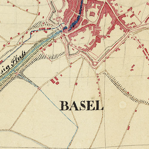
Baaderkarte 1836
Die Karte ist eine Umarbeitung und Reduktion von bestehendem Kartenmaterial in eine Kartenvorlage im Massstab 1:25'000 und wurde 1836 erstellt von Friedrich Baader. Der Auftrag dazu wurde erteilt von Guillaume-Henri Dufour. Dieser war in seiner Funktion auch zuständig für die eidgenössische Vermessungen und verwendete diese Kartenvorlage von Baader als Grundlage für die sogenannte «Dufourkarte» [Karte 1:100'000 der Schweiz, 1845-1864].
Simple
- Date (Creation)
- 1836-01-01
- Status
- Completed
Owner
- Spatial representation type
- Grid
Spatial resolution
Equivalent scale
- Denominator
- 5000
Spatial resolution
- Spatial resolution
- 1 m
- Topic category
-
- A Imagery base maps earth cover
Extent
Extent
- Description
-
Basel
))

- Maintenance and update frequency
- Not planned
- geocat.ch
-
-
historic map
-
- geocat.ch
-
-
opendata.swiss
-
Resource constraints
- Other constraints
-
Die Geodaten sind öffentlich zugänglich. (Zugangsberechtigungsstufe [A] = öffentlich)
- Other constraints
-
Es gelten die Nutzungsbedingungen für Geodaten des Kantons Basel-Stadt. ( http://www.geo.bs.ch/agb)
Associated resource
- Association Type
- Resource is a description of associated resource
- Metadata Reference
Associated resource
- Title
-
Historische Landeskarten
- Association Type
- Reference to a master resource of which this one is a part
- Language
- Deutsch
- Character encoding
- UTF8
- Supplemental Information
-
Originalpläne: STABS, Planarchiv, G5,17 + G5,24
- Subtopic Category
- A1 Base Maps, Landscape Models
- Basic Geodata
- false
- Basic Geodata Type
- openData
- Distribution format
-
-
INTERLIS 1 (ITF)
-
Digital transfer options
- OnLine resource
-
MapBS
Öffentliches Auskunftssystem des Kantons Basel-Stadt
Digital transfer options
- OnLine resource
-
WMS BS
Die derzeit im WMS BS verfügbaren Datenebenen entsprechen, bis auf wenige Ausnahmen, den Geodaten, welche auch in MapBS dargestellt sind. Der WMS BS ist kostenlos nutzbar und bietet Zugriff auf öffentliche sowie beschränkt öffentliche Geodaten, wobei gegebenenfalls Benutzername und Passwort benötigt werden (Zugangsdaten von MapBS).
Digital transfer options
- OnLine resource
-
Permalink opendata.swiss
Permalink opendata.swiss
- Reference system identifier
- CH1903+ / LV95/EPSG: 2056
Metadata
- Metadata identifier
- 5b8c3804-3ac6-4bee-93bc-1fe7aea24441
- Language
- Deutsch
- Character encoding
- UTF8
- Language
- Français
- Character encoding
- UTF8
- Language
- Italiano
- Character encoding
- UTF8
- Language
- English
- Character encoding
- UTF8
Custodian
Type of resource
- Resource scope
- Dataset
- Metadata linkage
-
https://www.geocat.ch/geonetwork/srv/api/records/5b8c3804-3ac6-4bee-93bc-1fe7aea24441
- Date info (Creation)
- 2024-09-11T06:38:16.693Z
- Date info (Revision)
- 2026-04-13T09:15:05.430073Z
Metadata standard
- Title
-
eCH-0271