geocat.ch
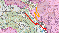
Routes cantonales - carte de chasse
Réseau routier (colorié en rouge) issu des routes cantonales permettant au chasseur de se déplacer sans restriction d'horaire. Les accès autorisés dans les zones de tranquillité de faune (colorié en jaune).
Simple
- Alternate title
-
Routes cantonales - carte de chasse
- Date (Creation)
- 2017-08-30
- Date (Revision)
- 2023-06-12
- Identifier
- 446
- Purpose
-
Informer le public sur le réseau routier sur la carte de chasse
- Status
- Completed
Custodian
- Spatial representation type
- Vector
Spatial resolution
Equivalent scale
- Denominator
- 25000
- Topic category
-
- L Environment
Extent
Extent
- Description
-
Canton of Valais (VS)
))

- Maintenance and update frequency
- Irregular
Resource format
- Title
-
ESRI Enterprise Geodatabase
- Date
- GEMET themes
-
-
natural dynamics
-
- GEMET
-
-
resources
-
- GEMET - INSPIRE themes, version 1.0
-
-
Habitats and biotopes
-
- GEMET - INSPIRE themes, version 1.0
-
-
Species distribution
-
- GEMET
-
-
hunting
-
- geocat.ch
-
-
opendata.swiss
-
Resource constraints
- Use limitation
-
aucunes
Resource constraints
- Access constraints
- Other restrictions
- Other constraints
-
Géodonnées accessibles au public (niveau A selon l'OGéo)
- Other constraints
-
Les conditions générales d'utilisation des géodonnées du Canton du Valais font foi ( https://www.vs.ch/fr/web/guest/information-legale).
- Language
- Français
- Character encoding
- UTF8
- Environment description
-
S:\Géodonnées VS\L2 Protection de la nature\Réseau routier (chasse).lyr
- Subtopic Category
- L2 Nature and Landscape Protection
- Distribution format
-
-
ESRI Shapefile (SHP)
-
OGC Web Map Service (WMS)
-
ArcGIS REST Feature Service
-
Distributor
Digital transfer options
- OnLine resource
-
Géoportail du Canton du Valais
Géoportail du Canton du Valais
Digital transfer options
- OnLine resource
-
OpenData Valais
OpenData Valais - Site de téléchargement de géodonnées à l'Etat du Valais : multiformat et WebMercator
Digital transfer options
- OnLine resource
-
Landing Page
Landing Page pour opendata
Digital transfer options
- OnLine resource
-
Permalink opendata.swiss
Permalink opendata.swiss
Digital transfer options
- OnLine resource
-
11
Réseau routier (chasse)
Digital transfer options
- OnLine resource
-
Rt_cant_carte_chasse
Rt_cant_carte_chasse
Digital transfer options
- OnLine resource
-
Routes forestières autorisées Rarogne oriental-Conches
Routes forestières autorisées Rarogne oriental-Conches
- Statement
-
Extraction du réseau routier du SDM
- Hierarchy level
- Dataset
- Description
-
Extraction, retravail sur la géométrie et ajouts de segments pour les connexions
- Geometric object type
- Curve
- Geometric object count
- 709
- Reference system identifier
- EPSG:2056/CH1903+_MN95
Metadata
- Metadata identifier
- 5a81aeb0-4e20-4217-98b4-d2b14fdd5c51
- Language
- Français
- Character encoding
- UTF8
- Language
- Deutsch
- Character encoding
- UTF8
- Language
- Italiano
- Character encoding
- UTF8
- Language
- English
- Character encoding
- UTF8
- Language
- Rumantsch
- Character encoding
- UTF8
Distributor
Type of resource
- Resource scope
- Dataset
- Metadata linkage
-
https://www.geocat.ch/geonetwork/srv/api/records/5a81aeb0-4e20-4217-98b4-d2b14fdd5c51
- Date info (Creation)
- 2018-03-09T13:59:18Z
- Date info (Revision)
- 2026-04-13T09:36:10.483303Z
Metadata standard
- Title
-
eCH-0271