geocat.ch
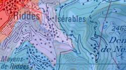
Carte des aptitudes climatiques pour l’agriculture en Suisse (VS)
La carte établie à l'échelle 1:200 000 reflète, une appréciation générale des conditions climatiques et des restrictions à l'égard de l'agriculture, subdivisées en vingt catégories d'aptitudes. Son but est de souligner les différences sensibles relatives aux possibilités de culture propres aux diverses régions.
Simple
- Alternate title
-
Carte d'aptitude climatique (VS)
- Date (Creation)
- 2008-10-23
- Identifier
- 58
- Purpose
-
On entend ainsi éveiller la compréhension à l'égard de la nécessité de prêter attention sous le rapport non seulement quantitatif, mais également qualitatif, au maintien d'une surface agricole suffisante.
- Status
- Completed
Custodian
- Hours of service
-
8h00-17h00
- Spatial representation type
- Vector
Spatial resolution
Equivalent scale
- Denominator
- 200000
- Topic category
-
- K Climatology, meteorology, atmosphere
Extent
Extent
- Description
-
Canton of Valais (VS)
))

- Maintenance and update frequency
- Not planned
Resource format
- Title
-
ESRI Enterprise Geodatabase
- Date
- GEMET themes
-
-
agriculture
-
- GEMET
-
-
climatic effect
-
- geocat.ch
-
-
cultivation suitability
-
official geodata
-
Resource constraints
- Use limitation
-
Aucune
Resource constraints
- Access constraints
- Other restrictions
- Other constraints
-
Géodonnées accessibles au public (niveau A selon l'OGéo)
- Other constraints
-
Les conditions générales d'utilisation des géodonnées du Canton du Valais font foi ( https://www.vs.ch/fr/web/guest/information-legale).
- Language
- Deutsch
- Character encoding
- UTF8
- Environment description
-
S:\Géodonnées VS\K Atmosphère, climatologie\Carte d_aptitude climatique.lyr
- Basic Geodata
- true
- Basic Geodata ID
-
77.1
- Basic Geodata Legal Level
- Federal
- Basic Geodata Type
- basicGeodata
- Distribution format
-
-
ESRI Shapefile (SHP)
-
autres formats sur demande / andere Formate auf Anfrage
-
Distributor
- Statement
-
Zusammen mit der Meteorologischen Zentralanstalt und anderen interessierten Kreisen wurden das Geographisches Institut der Universität Bern und die Eidg. landwirtschaftliche Forschungsanstalt Changins mit der Ausarbeitung der Karte beauftragt. Massstab 1:200'000, 4 Blätter, 1977 Erhebungszeitpunkt der Grundlagendaten: 1973-1976.
- Hierarchy level
- Dataset
- Description
-
La carte reflète une appréciation générale des conditions climatiques et des restrictions à l'égard de l'agriculture, subdivisées en vingt catégories d'aptitudes. Les zones d'aptitudes constituent les unités de la carte et sont basées sur une comparaison des seuils méteorologiques. Les lignes ont été digitalisés d'après des transparents A0 de la L+T.
- Geometric object type
- Surface
- Geometric object count
- 22
- Reference system identifier
- EPSG:2056/CH1903+_MN95
Metadata
- Metadata identifier
- 594696bf-82c7-4ef2-8550-f611e8de3f06
- Language
- Français
- Character encoding
- UTF8
- Language
- Deutsch
- Character encoding
- UTF8
- Language
- Italiano
- Character encoding
- UTF8
- Language
- English
- Character encoding
- UTF8
- Language
- Rumantsch
- Character encoding
- UTF8
Distributor
Type of resource
- Resource scope
- Dataset
- Metadata linkage
-
https://www.geocat.ch/geonetwork/srv/api/records/594696bf-82c7-4ef2-8550-f611e8de3f06
- Date info (Creation)
- 2014-12-12T16:26:33Z
- Date info (Revision)
- 2026-04-13T09:46:22.560636Z
Metadata standard
- Title
-
eCH-0271