geocat.ch
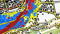
Carte des zones de danger d'inondation du Rhône en mai 2011
Carte des zones de danger d'inondation du Rhône, mise à l'enquête publique en mai 2011
Simple
- Alternate title
-
Carte de danger du Rhône en 2011
- Date (Creation)
- 2008-05-01
- Date (Publication)
- 2011-05-01
- Identifier
- 537
- Purpose
-
Plan d'Aménagement de la troisième correction du Rhône
- Status
- Completed
Custodian
- Spatial representation type
- Vector
Spatial resolution
Equivalent scale
- Denominator
- 10000
- Topic category
-
- F Geoscientific information
- I Inland waters
Extent
Extent
- Description
-
Canton of Valais (VS)
))

- Maintenance and update frequency
- Not planned
Resource format
- Title
-
ESRI Enterprise Geodatabase
- Date
- GEMET themes
-
-
water
-
- GEMET themes
-
-
disasters, accidents, risk
-
- GEMET - INSPIRE themes, version 1.0
-
-
Hydrography
-
- GEMET - INSPIRE themes, version 1.0
-
-
Natural risk zones
-
Resource constraints
- Use limitation
-
Aucunes
Resource constraints
- Access constraints
- Other restrictions
- Other constraints
-
Géodonnées partiellement accessibles aux public (niveau B selon l'OGéo).
- Other constraints
-
Les conditions générales d'utilisation des géodonnées du Canton du Valais font foi ( https://www.vs.ch/fr/web/guest/information-legale).
- Language
- Français
- Character encoding
- UTF8
- Environment description
-
S:\Géodonnées VS\Z Projets\Rhône 3\Carte des zones de danger d'inondation du Rhône2011.lyr
- Subtopic Category
- F3 Natural Hazards
- Distribution format
-
-
ESRI Shapefile (SHP)
-
autres formats sur demande / andere Formate auf Anfrage
-
Distributor
- Statement
-
Carte élaborée par un bureau spécialisé
- Hierarchy level
- Dataset
- Description
-
Modélisation hydraulique 2D
- Geometric object type
- Surface
- Geometric object count
- 8425
- Reference system identifier
- EPSG:2056/CH1903+_MN95
Metadata
- Metadata identifier
- 580a121c-6623-499e-9dc4-5644bb3cb104
- Language
- Français
- Character encoding
- UTF8
- Language
- Deutsch
- Character encoding
- UTF8
- Language
- Italiano
- Character encoding
- UTF8
- Language
- English
- Character encoding
- UTF8
- Language
- Rumantsch
- Character encoding
- UTF8
Distributor
Type of resource
- Resource scope
- Dataset
- Metadata linkage
-
https://www.geocat.ch/geonetwork/srv/api/records/580a121c-6623-499e-9dc4-5644bb3cb104
- Date info (Creation)
- 2020-07-06T12:11:10Z
- Date info (Revision)
- 2026-04-13T09:41:22.091803Z
Metadata standard
- Title
-
eCH-0271