geocat.ch
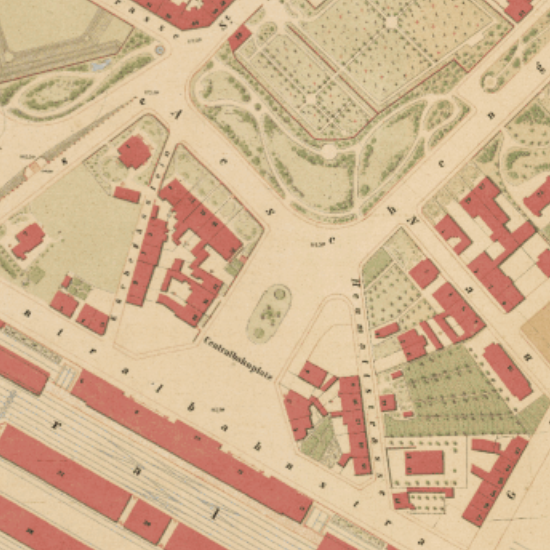
Situationsplan 1862 (Löffelplan)
Aufgenommen in den Jahren 1857-59 durch Geometer L.H. Loeffel mit Benützung der Aufnahmen der äusseren Stadtteile von Geometer R. Falkner. Der Plan wurde im Jahre 1862 gedruckt.
Semplice
- Data (Creazione)
- 1862-01-01
- Stato
- Completato
Proprietario
- Tipo di rappresentazione spaziale
- Raster
Risoluzione spaziale
- Distanza di risoluzione
- 0.25 m
Risoluzione spaziale
Frazione rappresentativa
- Denominatore
- 2000
- Categoria ISO
-
- A Mappe di base con immagini della copertura terrestre
Estensione
Estensione
- Descrizione
-
Situationsplan Loeffel, 1862
- Identificatore geografico
- BS
))

- Frequenza di aggiornamento
- Non pianificato
- geocat.ch
-
-
carta storica
-
- geocat.ch
-
-
opendata.swiss
-
Vincoli sulle risorse
- Altri vincoli
-
Die Geodaten sind öffentlich zugänglich. (Zugangsberechtigungsstufe [A] = öffentlich)
- Altri vincoli
-
Es gelten die Nutzungsbedingungen für Geodaten des Kantons Basel-Stadt. ( http://www.geo.bs.ch/agb)
Risorsa associata
- Tipo di associazione
- È una descrizione di
- Riferimento metadati
Risorsa associata
- Titolo
-
Historische Pläne
- Tipo di associazione
- Citazione di un'opera più ampia
- Lingua
- Deutsch
- Codifica dei caratteri
- UTF8
- Categoria di sottotema
- A1 Mappe di base, modelli paesaggistici
- Geodati di base
- false
- Tipo di geodati di base
- openData
- Formato (codifica)
-
-
GeoTIFF (GEOTIFF)
-
Tagged Image File Format (TIFF)
-
JPEG (JPG)
-
Distributore
- Orario di servizio
-
Mo - Do: 8:00 bis 12:00, 13:30 bis 16:30, Fr: 8:00 bis 12:00, 13:30 bis 16:00
Opzioni di trasferimento digitale
- Risorsa online
-
MapBS
Öffentliches Auskunftssystem des Kantons Basel-Stadt
Opzioni di trasferimento digitale
- Risorsa online
-
Geodaten-Shop
Öffentlich zugänglicher Geodaten-Downloaddienst des Kantons Basel-Stadt
Opzioni di trasferimento digitale
- Risorsa online
-
WMS BS
Die derzeit im WMS BS verfügbaren Datenebenen entsprechen, bis auf wenige Ausnahmen, den Geodaten, welche auch in MapBS dargestellt sind. Der WMS BS ist kostenlos nutzbar und bietet Zugriff auf öffentliche sowie beschränkt öffentliche Geodaten, wobei gegebenenfalls Benutzername und Passwort benötigt werden (Zugangsdaten von MapBS).
Opzioni di trasferimento digitale
- Risorsa online
-
Permalink opendata.swiss
Permalink opendata.swiss
- Nome del sistema di riferimento
- CH1903+ / LV95/EPSG: 2056
Metadati
- Identificativo della scheda
- 534bb611-2700-4b3a-bd59-f0cdf593c470
- Lingua
- Deutsch
- Codifica dei caratteri
- UTF8
- Lingua
- Français
- Codifica dei caratteri
- UTF8
- Lingua
- Italiano
- Codifica dei caratteri
- UTF8
- Lingua
- English
- Codifica dei caratteri
- UTF8
Custode
Tipo di risorsa
- Ambito di applicazione della risorsa
- Set di dati
- Collegamento ai metadati
-
https://www.geocat.ch/geonetwork/srv/api/records/534bb611-2700-4b3a-bd59-f0cdf593c470
- Informazioni sulla data (Creazione)
- 2013-02-04T10:49:54Z
- Informazioni sulla data (Revisione)
- 2026-04-13T09:26:56.263384Z
Standard dei metadati
- Titolo
-
eCH-0271