geocat.ch
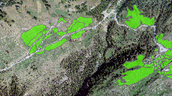
Secteurs "Vente aux étrangers"
Secteurs dans lesquels une vente d'immeuble à des personnes de l'étranger peut être autorisée.
Simple
- Alternate title
-
Secteurs "Vente aux étrangers"
- Date (Creation)
- 2014-12-31
- Date (Revision)
- 2024-09-16
- Identifier
- 475
- Purpose
-
Respecter les contingents attribués pour la vente d'immeuble à des personnes de l'étranger (lex Koller)
- Status
- Completed
Custodian
- Spatial representation type
- Vector
Spatial resolution
Equivalent scale
- Denominator
- 25000
- Topic category
-
- E Planning cadastre
Extent
Extent
- Description
-
Canton of Valais (VS)
))

- Maintenance and update frequency
- Annually
- Maintenance note
-
Adaptation périodique en fonction des modifications du PAZ
Resource format
- Title
-
ESRI Enterprise Geodatabase
- Date
- GEMET themes
-
-
economics
-
- GEMET
-
-
economic activity
-
- GEMET
-
-
regional planning
-
- GEMET
-
-
territory
-
- geocat.ch
-
-
local planning
-
- geocat.ch
-
-
land use zone
-
Resource constraints
- Use limitation
-
Aucune
Resource constraints
- Access constraints
- Other restrictions
- Other constraints
-
Géodonnées accessibles au public (niveau A selon l'OGéo)
- Other constraints
-
Les conditions générales d'utilisation des géodonnées du Canton du Valais font foi ( https://www.vs.ch/fr/web/guest/information-legale).
- Language
- Français
- Character encoding
- UTF8
- Subtopic Category
- E1 Spatial Planning, Spatial Development
- Distribution format
-
-
ESRI Shapefile (SHP)
-
autres formats sur demande / andere Formate auf Anfrage
-
Distributor
Digital transfer options
- OnLine resource
-
Géoportail du Canton du Valais
Géoportail du Canton du Valais
- Statement
-
Données numérisées sur la base des plans d'affectation des communes, complété par les périmètres définis par le canton
- Hierarchy level
- Dataset
- Description
-
Numérisation
- Geometric object type
- Surface
- Geometric object count
- 9695
- Reference system identifier
- EPSG: 21781/CH1903+_MN95
Metadata
- Metadata identifier
- 4de3948d-36b9-413d-9f7a-7075df0e094d
- Language
- Français
- Character encoding
- UTF8
- Language
- Deutsch
- Character encoding
- UTF8
- Language
- Italiano
- Character encoding
- UTF8
- Language
- English
- Character encoding
- UTF8
- Language
- Rumantsch
- Character encoding
- UTF8
Distributor
Type of resource
- Resource scope
- Dataset
- Metadata linkage
-
https://www.geocat.ch/geonetwork/srv/api/records/4de3948d-36b9-413d-9f7a-7075df0e094d
- Date info (Creation)
- 2018-08-03T13:44:43Z
- Date info (Revision)
- 2026-04-13T09:21:13.828486Z
Metadata standard
- Title
-
eCH-0271