 geocat.ch
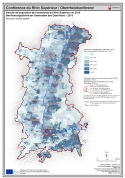
Densité de population 2015 PDF / Bevölkerungsdichte 2015 PDF
Carte PDF de la densité de population communale du Rhin Supérieur au 01/01/2015
PDF Karte der Bevölkerungsdichte Gemeinden der Oberrheinkonferenz am 01/01/2015
Simple
- Date (Creation)
- 2018-02-07
- Presentation form
- Hardcopy map
- Status
- Completed
- Topic category
-
- M Society
Extent
Extent
N
S
E
W
))
- Maintenance and update frequency
- Unknown
- Keywords
-
-
densité;population;PDF;carte;Karte;Rhin Supérieur;Rhin;Supérieur;2015;Bevölkerung;dichte;Bevölkerungsdichte;communale;Gemeinden
-
Resource constraints
- Use limitation
-
© OSM contributors - INSEE - STAL BW - STALA RP - OFS - GeoRhena
- Access constraints
- Copyright
- Use constraints
- Copyright
- Language
- Français
- Distribution format
-
-
PDF
-
PDF
-
Metadata
- Metadata identifier
- 4d88b22e-6b9f-49a0-8b33-84f8013f37a7
- Language
- Français
- Character encoding
- UTF8
Type of resource
- Resource scope
- staticMap
- Name
-
1
- Date info (Revision)
- 2025-06-18T14:46:02.907965Z
Metadata standard
- Title
-
ISO 19115-3:2018
- Edition
-
1.0
)))