geocat.ch
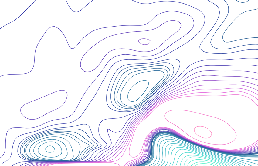
Aeromagnetic Map of Switzerland 1:500000
The overall magnetisation of a rock consists of induced magnetisation caused by the Earth's magnetic field and of remanent magnetisation acquired by the rock during its formation. Regional or local differences in the geomagnetic field on the basis of a global model, referred to as anomalies, are measured from aircraft. These anomalies can make it possible to identify the geological and tectonic structures and the presence of mineral deposits. The Aeromagnetic Map of Switzerland shows the total intensity of the magnetic field (epoch 1981.5) measured at an altitude of 5000 m a.s.l. - Paper map: total field, E. KLINGELE, 1982. - Vector map: online version, aeromagnetic residual anomalies (removal of regional trends), E. KLINGELE, 2009.
Simple
- Alternate title
-
Aeromagnetics 500
- Date (Publication)
- 1982-12-31
- Identifier
- ch.swisstopo.geologie-geophysik-aeromagnetische_karte_schweiz
- Purpose
-
Übersicht über die Magnetfeldstärke in der Schweiz
- Status
- Completed
Owner
- Spatial representation type
- Vector
Spatial resolution
Equivalent scale
- Denominator
- 500000
- Topic category
-
- F Geoscientific information
Extent
Extent
- Description
-
National Map 1:500'000
- Geographic identifier
- NM500
))

- Maintenance and update frequency
- Not planned
- Duration of Conservation
- 275
- Appraisal of Archival Value
- A
- Reason for Archiving Value
- Evidence of business practice
- geocat.ch
-
-
opendata.swiss
-
geophysical map
-
official geodata
-
e-geo.ch
-
Conservation and archiving planning AAP - Confederation
-
- GEMET
-
-
magnetism
-
geophysics
-
- geocat.ch
-
-
FSDI Federal Spatial Data Infrastructure
-
Associated resource
- Title
-
Geophysical maps
- Association Type
- Reference to a master resource of which this one is a part
- Language
- Deutsch
- Character encoding
- UTF8
- Language
- Français
- Character encoding
- UTF8
- Subtopic Category
- F1 Geology
- Basic Geodata
- true
- Basic Geodata ID
-
47.9
- Basic Geodata Legal Level
- Federal
- Distribution format
-
-
ESRI Shapefile (SHP)
-
Digital transfer options
- OnLine resource
-
Vorschau map.geo.admin.ch
Preview map.geo.admin.ch
Digital transfer options
- OnLine resource
-
ch.swisstopo.geologie-geophysik-aeromagnetische_karte_schweiz
WMS-FSDI service, layer "Aeromagnetics 500"
Digital transfer options
- OnLine resource
-
ch.swisstopo.geologie-geophysik-aeromagnetische_karte_schweiz
WMTS-FSDI service, layer "Aeromagnetics 500"
Digital transfer options
Digital transfer options
Digital transfer options
- OnLine resource
-
RESTful API von geo.admin.ch
RESTful API from geo.admin.ch
- Statement
-
Diese Karte stellt vor dem Hintergrund der Landeskarte 1:500'000 und der Tektonischen Karte 1:500'000 die aeromagnetische Totalintensität dar.
- Hierarchy level
- Dataset
- Reference system identifier
- Referenzsystem entsprechend der zugrundeliegenden topographischen Karte (CH1903)
Metadata
- Metadata identifier
- 4cc706a2-0005-4cc6-8326-7b944a1d5b05
- Language
- Deutsch
- Character encoding
- UTF8
- Language
- Français
- Character encoding
- UTF8
- Language
- Italiano
- Character encoding
- UTF8
- Language
- English
- Character encoding
- UTF8
- Language
- Rumantsch
- Character encoding
- UTF8
Owner
Type of resource
- Resource scope
- Dataset
- Metadata linkage
-
https://www.geocat.ch/geonetwork/srv/api/records/4cc706a2-0005-4cc6-8326-7b944a1d5b05
- Date info (Creation)
- 2010-04-21T10:33:34Z
- Date info (Revision)
- 2026-04-13T09:30:33.607981Z
Metadata standard
- Title
-
eCH-0271