geocat.ch
Bevölkerungsstatistik: Einwohner
Statistique de la population : habitants
Statistica della popolazione: abitanti
Population Statistics: Inhabitants
Statistica da la populaziun: abitants
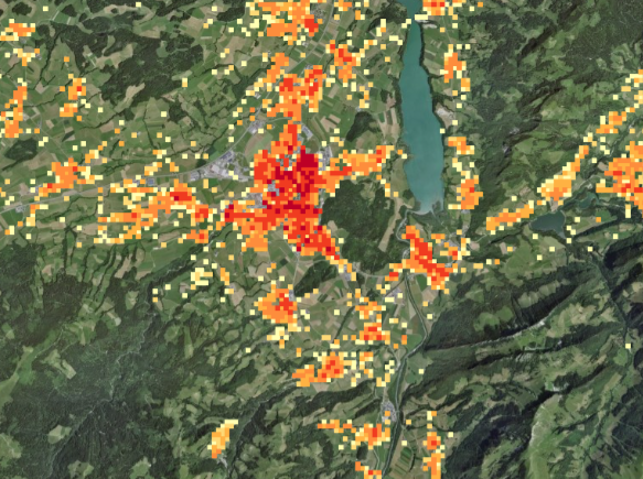
Seit 1990 werden für die im Rahmen der Eidgenössischen Volkszählungen erfassten Gebäuden mit Wohnzweck Koordinaten bestimmt. Seit 2010 wird die Volkszählung auf der Grundlage einer Auswertung der Personenregister der Gemeinden und Kantone jährlich aktualisiert und mit Stichprobenerhebungen ergänzt. Die Statistik der Bevölkerung und der Haushalte (STATPOP) liefert Kennzahlen zum Bestand, zur Struktur (Alter, Geschlecht, Zivilstand, Staatsangehörigkeit usw.), zur Entwicklung und zur räumlichen Verteilung der Bevölkerung sowie Angaben zur Zahl und Grösse der Haushalte.
Depuis 1990 on a attribué des coordonnées aux bâtiments d'habitation identifiés par les recensements fédéraux de la population. Depuis 2010, le recensement de la population est réalisé sur la base de l'exploitation des registres des personnes communaux et cantonaux, complétée par des données issues d'échantillons. La statistique de la population et des ménages (STATPOP) fournit des chiffres clés sur l'effectif, la structure (âge, sexe, état civil, nationalité, etc.), l'évolution et la répartition géographique de la population, ainsi que des données sur le nombre et la taille des ménages.
Dal 1970 nell'ambito dei censimenti federali della popolazione vengono assegnate delle coordinate agli edifici rilevati. Dal 2010, il censimento della popolazione è realizzato sfruttando i dati dei registri comunali e cantonali delle persone, dati completati con altri provenienti da campioni. La statistica della popolazione e delle economie domestiche (STATPOP) fornisce indicatori relativi all'effettivo delle persone, alla struttura della popolazione (età, sesso, stato civile, cittadinanza ecc.), all'evoluzione e alla distribuzione territoriale della popolazione nonché informazioni sul numero e sulle dimensioni delle economie domestiche.
Since 1990, the residential buildings recorded in federal national censuses have been given coordinates. Since 2010, the census is annually updated based on the exploitation of the registers of inhabitants of cantons and communes which is complemented by sample surveys. The Population and Households Statistics (STATPOP) provides key figures on the size, structure (age, sex, civil status, nationality, etc.), development and spatial distribution of the population as well as information on the number and size of households.
Dapi l'onn 1990 vegnan definidas coordinatas per ils edifizis cun intents d'abitar che vegnan registrads en il rom da las dumbraziuns federalas dal pievel. Dapi l'onn 2010 vegn la dumbraziun dal pievel actualisada mintga onn sin basa d'ina evaluaziun dals registers da persunas da las vischnancas e dals chantuns e cumplettada cun enquistas da sondagi. La Statistica da la populaziun e da las chasadas (STATPOP) furnescha indicaturs davart il dumber, la structura (vegliadetgna, schlattaina, stadi civil, naziunalitad e.u.v.), il svilup e la repartiziun geografica da la populaziun sco er indicaziuns davart il dumber e la grondezza da las chasadas.
Simple
-
Autre titreAltri nomi o acronimiAlternate titleAlternate titleAlternativtitel
-
Bevölkerung (Einwohner)
Population (habitants)
Popolazione (abitanti)
Population (residents)
Populaziun (abitants)
-
Date (Création)Data (Creazione)Date (Creation)Date (Creation)Datum (Erstellung)
- 2017-12-13
-
IdentifiantIdentificatoreIdentifierIdentifierKennung
- ch.bfs.volkszaehlung-bevoelkerungsstatistik_einwohner
-
ButScopoPurposePurposeZweck
-
Die Volkszählung zeichnet die demografische, räumliche, soziale und wirtschaftliche Entwicklung der Schweiz seit 1850 nach. Ihre Ergebnisse dienen der Planung und Entscheidung in vielen wichtigen Gebieten: Beschäftigungspolitik, Bildungswesen, Familien- und Sozialpolitik, Umweltschutz, Verkehrs- und Siedlungspolitik, Wirtschaftsförderung. Sie ist zudem unentbehrlich für die Auswertung von Stichprobenerhebungen (Gewichtung und Hochrechnung) sowie für Berechnungen im Zusammenhang mit anderen Statistiken.
Le recensement fédéral de la population décrit l'évolution démographique, spatiale, sociale et économique de la Suisse depuis 1850. Ses résultats servent à la planification et à la prise de décisions dans de nombreux domaines: politique de l'emploi, formation, politique sociale et familiale, protection de l'environnement, transports, aménagement du territoire, promotion économique. Le recensement est aussi indispensable dans l'exploitation des relevés par sondage (pondération et extrapolation) et dans le calcul d'indicateurs produits dans d'autres statistiques.
-
ÉtatStatoStatusStatusBearbeitungsstatus
-
ContinuIn corsoOn goingOn goingKontinuierliche Aktualisierung
Point de contact
Punto di contatto
Point of contact
Point of contact
Ansprechpartner
-
Type de représentation spatialeTipo di rappresentazione spazialeSpatial representation typeSpatial representation typeRäumliche Darstellungsart
-
Texte ou tableauTesto, tabellaText, tableText, tableText der Tabelle
Résolution spatiale
Risoluzione spaziale
Spatial resolution
Spatial resolution
Räumliche Auflösung
-
Distance de résolutionDistanza di risoluzioneSpatial resolutionSpatial resolutionDistanz
- 100 m
-
Catégorie de thèmeCategoria ISOTopic categoryTopic categoryThematik
-
-
M SociétéM SocietàM SocietyM SocietyM Gesellschaft
-
Étendue
Estensione
Extent
Extent
Ausdehnung
Étendue
Estensione
Extent
Extent
Ausdehnung
-
DescriptionDescrizioneDescriptionDescriptionBeschreibung
-
Switzerland
Schweiz
Suisse
Svizzera
Svizra
))

-
Fréquence de mise à jourFrequenza di aggiornamentoMaintenance and update frequencyMaintenance and update frequencyWartungsintervall
-
AnnuelleAnnualmenteAnnuallyAnnuallyJährlich
-
Remarque sur la mise à jourNota sull'aggiornamentoMaintenance noteMaintenance noteAnmerkung
-
alle 10 Jahre, ab 2010 jährliche Registererhebung
tous les 10 ans, après 2010 recensements des registres annuels
-
Durée de conservationDurata di conservazioneDuration of ConservationDuration of ConservationAufbewahrungsdauer NV in Jahren
- 100
-
Évaluation de la valeur archivistiqueValutazione del valore archivisticoAppraisal of Archival ValueAppraisal of Archival ValueBewertung Archivwürdigkeit
-
NNNNN
-
Commentaire sur la valeur d'archivageCommento sul valore di archiviazioneComment on Archival ValueComment on Archival ValueBemerkung zur Archivwürdigkeit
-
Subset eines archivwürdigen Datensatzes
- geocat.ch
-
-
géoservice de base
geoservizio di base
official geoservice
-
enquête
rilevamento
survey
-
opendata.swiss
opendata.swiss
opendata.swiss
opendata.swiss
-
- GEMET - INSPIRE themes, version 1.0
-
-
Répartition de la population — démographie
Distribuzione della popolazione — demografia
Population distribution — demography
-
- GEMET
-
-
population
popolazione umana
human population
-
statistiques
statistica
statistics
-
habitant
abitante
inhabitant
-
- geocat.ch
-
-
BGDI Bundesgeodaten-Infrastruktur
IFDG l’Infrastructure Fédérale de données géographiques
IFDG Infrastruttura federale dei dati geografici
FSDI Federal Spatial Data Infrastructure
-
Contraintes sur la ressource
Vincoli sulle risorse
Resource constraints
Resource constraints
Ressourcenbeschränkungen
-
Contraintes d'accèsVincoli di accessoAccess constraintsAccess constraintsZugriffsbeschränkungen
-
Droits de propriété intellectuelleDiritti di proprietà intellettualeIntellectual property rightsIntellectual property rightsGeistiges Eigentum
-
Contraintes d'utilisationVincoli d'usoUse constraintsUse constraintsNutzungseinschränkungen
-
Autres restrictionsAltre restrizioniOther restrictionsOther restrictionsAndere Beschränkungen
-
Autres contraintesAltri vincoliOther constraintsOther constraintsAndere Einschränkungen
- Opendata BY ASK: Freie Nutzung. Quellenangabe ist Pflicht. Kommerzielle Nutzung nur mit Bewilligung des Datenlieferanten zulässig.Opendata BY ASK: Utilisation libre. Obligation d’indiquer la source. Utilisation commerciale uniquement avec l’autorisation du fournisseur des données.Opendata BY ASK: Libero utilizzo. Indicazione della fonte obbligatoria. Utilizzo a fini commerciali ammesso soltanto previo consenso del titolare dei dati.Opendata BY ASK: Open use. Must provide the source. Use for commercial purposes requires permission of the data owner.
Ressource associée
Risorsa associata
Associated resource
Associated resource
Verlinkte Ressource
-
Type d'associationTipo di associazioneAssociation TypeAssociation TypeAssoziationstyp
-
Citation de travail plus largeCitazione di un'opera più ampiaReference to a master resource of which this one is a partReference to a master resource of which this one is a partÜbergeordneter Datenbestand
-
Metadata ReferenceRiferimento metadatiMetadata ReferenceMetadata ReferenceMetadatenreferenz
Ressource associée
Risorsa associata
Associated resource
Associated resource
Verlinkte Ressource
-
TitreTitoloTitleTitleTitel
-
Eidg. Volkszählungen
Recensements fédéraux de la population
Censimenti federali della popolazione
Federal Population Censuses
Dumbraziuns federalas dal pievel
-
Type d'associationTipo di associazioneAssociation TypeAssociation TypeAssoziationstyp
-
Citation de travail plus largeCitazione di un'opera più ampiaReference to a master resource of which this one is a partReference to a master resource of which this one is a partÜbergeordneter Datenbestand
-
LangueLinguaLanguageLanguageSprache
- Deutsch
-
Encodage de caractèresCodifica dei caratteriCharacter encodingCharacter encodingZeichenkodierung
-
Utf8UTF8UTF8UTF8Utf8
-
LangueLinguaLanguageLanguageSprache
- Français
-
Encodage de caractèresCodifica dei caratteriCharacter encodingCharacter encodingZeichenkodierung
-
Utf8UTF8UTF8UTF8Utf8
-
LangueLinguaLanguageLanguageSprache
- Italiano
-
Encodage de caractèresCodifica dei caratteriCharacter encodingCharacter encodingZeichenkodierung
-
Utf8UTF8UTF8UTF8Utf8
-
LangueLinguaLanguageLanguageSprache
- English
-
Encodage de caractèresCodifica dei caratteriCharacter encodingCharacter encodingZeichenkodierung
-
Utf8UTF8UTF8UTF8Utf8
-
Informations supplémentairesInformazioni supplementariSupplemental InformationSupplemental InformationZusätzliche Informationen
-
Hektarauswertungen der Volkszählungen werden bei GEOSTAT in relationalen Datenbanken verwaltet, in welchen jede Hektare (eines für alle Erhebungen identischen Standardrasters) einen Datenrecord darstellt. Für die Diffusion können daraus gleichermassen strukturierte Textdateien (Normalfall), bei Bedarf aber auch GIS-kompatible Vektor- (Punktdaten) oder Rasterdaten (GRID, GeoTIFF) erzeugt werden
Des exploitations hectométriques des recensements fédérals de la population sont gérés par GEOSTAT dans des banques de données relationnelles. A chaque hectare (d'un grille standardisé pour tous les relevés) correspond un enregistrement. Les résultats sont diffusés sous la forme de fichiers texte structurés (cas normal) ou, au besoin, sous la forme de données vectorielles (points) ou des données raster (GRID, GeoTIFF) compatibles SIG.
-
Géodonnées de baseGeodati di baseBasic GeodataBasic GeodataGeobasisdaten
- true
-
Identifiant Géodonnées de baseIdentificativo dei geodati di baseBasic Geodata IDBasic Geodata IDIdentifikator des Geobasisdatensatzes
-
15.2
-
Niveau des géodonnées de baseLivello legale dei geodati di baseBasic Geodata Legal LevelBasic Geodata Legal LevelGeobasisdatenebene
-
FédéralFederaleFederalFederalNational
-
Format de distributionFormato (codifica)Distribution formatDistribution formatAbgabeformat
-
-
TEXT, semicolon separated (CSV)
-
Options de transfert numérique
Opzioni di trasferimento digitale
Digital transfer options
Digital transfer options
Optionen für die digitale Übertragung
-
Ressource en ligneRisorsa onlineOnLine resourceOnLine resourceOnline
-
Vorschau map.geo.admin.ch
Vorschau map.geo.admin.chAperçu map.geo.admin.chPrevisione map.geo.admin.chPreview map.geo.admin.ch
Options de transfert numérique
Opzioni di trasferimento digitale
Digital transfer options
Digital transfer options
Optionen für die digitale Übertragung
-
Ressource en ligneRisorsa onlineOnLine resourceOnLine resourceOnline
-
Variablenliste
Options de transfert numérique
Opzioni di trasferimento digitale
Digital transfer options
Digital transfer options
Optionen für die digitale Übertragung
-
Ressource en ligneRisorsa onlineOnLine resourceOnLine resourceOnline
-
ch.bfs.volkszaehlung-bevoelkerungsstatistik_einwohner
WMS-BGDI Dienst, Layer "Bevölkerung (Einwohner)"Service WMS-IFDG, couche "Population (habitants)"Servizio WMS-IFDG, strato "Popolazione (abitanti)"WMS-FSDI service, layer "Population (residents)"WMS-BGDI Dienst, Layer "Bevölkerung (Einwohner)"
Options de transfert numérique
Opzioni di trasferimento digitale
Digital transfer options
Digital transfer options
Optionen für die digitale Übertragung
-
Ressource en ligneRisorsa onlineOnLine resourceOnLine resourceOnline
-
ch.bfs.volkszaehlung-bevoelkerungsstatistik_einwohner
WMTS-BGDI Dienst, Layer "Bevölkerung (Einwohner)"Service WMTS-IFDG, couche , Layer "Population (habitants)"Servizio WMTS-IFDG, strato "Popolazione (abitanti)"WMTS-FSDI service, layer "Population (residents)"WMTS-BGDI Dienst, Layer "Bevölkerung (Einwohner)"
Options de transfert numérique
Opzioni di trasferimento digitale
Digital transfer options
Digital transfer options
Optionen für die digitale Übertragung
-
Ressource en ligneRisorsa onlineOnLine resourceOnLine resourceOnline
-
Datenbeschreibung
Datenbeschreibung der Geodaten der Statistik der Bevölkerung und Haushalte (STATPOP)Description des géodonnées de la statistique de la population et des ménagements (STATPOP)Geodata description of the population and households statistics (STATPOP)
Options de transfert numérique
Opzioni di trasferimento digitale
Digital transfer options
Digital transfer options
Optionen für die digitale Übertragung
-
Ressource en ligneRisorsa onlineOnLine resourceOnLine resourceOnline
-
RESTful API von geo.admin.ch
RESTful API von geo.admin.chRESTful API de geo.admin.chRESTful API da geo.admin.chRESTful API from geo.admin.chRESTful API dad geo.admin.ch
Options de transfert numérique
Opzioni di trasferimento digitale
Digital transfer options
Digital transfer options
Optionen für die digitale Übertragung
-
Ressource en ligneRisorsa onlineOnLine resourceOnLine resourceOnline
-
Geodata (csv)
Options de transfert numérique
Opzioni di trasferimento digitale
Digital transfer options
Digital transfer options
Optionen für die digitale Übertragung
-
Ressource en ligneRisorsa onlineOnLine resourceOnLine resourceOnline
-
GEOSTAT
GEOSTAT ist das BFS-Kompetenzzentrum für Geoinformation und digitale Bildverarbeitung.GEOSTAT est le centre de compétence pour la géoinformation et le traitement numérique des images digitales de l'OFS.
Options de transfert numérique
Opzioni di trasferimento digitale
Digital transfer options
Digital transfer options
Optionen für die digitale Übertragung
-
Ressource en ligneRisorsa onlineOnLine resourceOnLine resourceOnline
-
Statistik der Bevölkerung und der Haushalte
-
Généralités sur la provenanceInformazioni generali sulla provenienzaStatementStatementErklärung
-
Durch die Geokodierung wird die Lage der Wohngebäude mit Hilfe ihrer Koordinaten (gemäss Landeskarte) erfasst, wodurch eine räumliche Zuordnung der Volkszählungsergebnisse ermöglicht wird. Bei der Geokodierung der Volkszählung 1990 wurden vier Hauptverfahren eingesetzt, wobei die Vorbereitungsarbeiten bei den Gemeinden und Kantonen lagen und die Digitalisierung und Weiterverarbeitung beim BFS. Die Volkszählung 2000 wurde auf der Basis des Eidgenössischen Gebäude- und Wohnungsregisters (GWR) in vier Phasen geokodiert: 1. Übernahme der Koordinaten aus der Geokodierung der früheren Volkszählungen 2. Übernahme zusätzlicher Gebäudekoordinaten aus amtlichen Vermessungsdaten oder kantonalen Registern 3. Identifizierung der in den zwei vorangehenden Phasen noch nicht lokalisierten Gebäude durch die Gemeinden oder Kantone und anschliessende Digitalisierung der Koordinaten beim BFS 4. Kontrolle und Validierung der Koordinaten beim BFS.
Le géocodage consiste à relever la situation des bâtiments d'habitation à l'aide de leurs coordonnées (conformément aux cartes nationales), ce qui permet d'établir une répartition spatiale pour les données du recensement de la population. Quatre procédés principaux ont été utilisés lors du géocodage du recensement de la population de 1990. Les travaux de préparation ont été réalisés par les communes et les cantons tandis que la numérisation et le traitement ont été du ressort de l'OFS. Le géocodage du recensement 2000 a été réalisé en quatre phases sur la base du géocodage du Registre fédéral des Bâtiments et des Logements: 1. reprise des coordonnées issues du géocodage des recensements précédents 2. reprise des coordonnées des bâtiments à partir des données de la mensuration officielle, ou à partir de fichiers cantonaux 3. localisation par les communes ou cantons des bâtiments non localisés dans les deux phases précédentes, puis saisie des coordonnées à l'OFS 4. contrôle et validation des coordonnées à l'OFS
-
NiveauLivelloHierarchy levelHierarchy levelBezugsebene
-
Jeu de donnéesSet di datiDatasetDatasetDatenbestand
-
DescriptionDescrizioneDescriptionDescriptionBeschreibung
-
Wo Kantone oder einzelne Städte bereits über Gebäudekoordinaten verfügten, wurden diese dem BFS direkt übermittelt. Für alle bereits in früheren Volkszählungen erfassten Gebäude wurden ebenfalls deren damals bestimmte Koordinaten übernommen. Für alle anderen Gebäude wurden die Koordinaten ab Plänen unterschiedlichster Art, welche von den Gemeinden vorbereitet wurden, durch das BFS oder Aussenstellen in einzelnen Kantonen bestimmt. Seit einigen Jahren werden die Koordinaten sukzessive durch die geometrisch genaueren Gebäudekoordinaten der Amtlichen Vermessung ersetzt und ergänzt.
Dans les cantons et les villes disposant déjà de coordonnées pour les bâtiments d'habitation, celles-ci ont été directement transmises à l'OFS. Pour tous les bâtiments déjà géocodés dans le cadre des recensements précédents, les coordonnées définies étaient aussi reprises. Pour tous les autres bâtiments, l'OFS, aussi bien que des services externes dans le cas de quelques cantons, ont déterminé les coordonnées à partir de plans très différants préparés par les communes. Depuis quelques années, les coordonnées sont successivement remplacées et complétées par les coordonnées plus précises issues de la mensuration officielle.
-
Nom du système de référenceNome del sistema di riferimentoReference system identifierReference system identifierName des Referenzsystems
- EPSG:2056
-
Fréquence de mise à jourFrequenza di aggiornamentoMaintenance and update frequencyMaintenance and update frequencyWartungsintervall
-
Comme nécessaireSecondo necessitàAs neededAs neededBei Bedarf
-
Remarque sur la mise à jourNota sull'aggiornamentoMaintenance noteMaintenance noteAnmerkung
-
Nachführung erfolgt für jede neue Volkszählung sowie, wenn Dokumentation fehlerhaft oder verbesserungsbedürftig.
Actualisation pour chaque recensement nouvel et en cas de fautes ou des améliorations de la documentation
Metadata
-
Identifiant des métadonnéesIdentificativo della schedaMetadata identifierMetadata identifierIdentifikator des Metadatensatzes
- 4bfbbf20-d90e-4131-8fe2-4c454ad45c16
-
LangueLinguaLanguageLanguageSprache
- Deutsch
-
Encodage de caractèresCodifica dei caratteriCharacter encodingCharacter encodingZeichenkodierung
-
Utf8UTF8UTF8UTF8Utf8
-
LangueLinguaLanguageLanguageSprache
- Français
-
Encodage de caractèresCodifica dei caratteriCharacter encodingCharacter encodingZeichenkodierung
-
Utf8UTF8UTF8UTF8Utf8
-
LangueLinguaLanguageLanguageSprache
- Italiano
-
Encodage de caractèresCodifica dei caratteriCharacter encodingCharacter encodingZeichenkodierung
-
Utf8UTF8UTF8UTF8Utf8
-
LangueLinguaLanguageLanguageSprache
- English
-
Encodage de caractèresCodifica dei caratteriCharacter encodingCharacter encodingZeichenkodierung
-
Utf8UTF8UTF8UTF8Utf8
-
LangueLinguaLanguageLanguageSprache
- Rumantsch
-
Encodage de caractèresCodifica dei caratteriCharacter encodingCharacter encodingZeichenkodierung
-
Utf8UTF8UTF8UTF8Utf8
Point de contact
Punto di contatto
Point of contact
Point of contact
Ansprechpartner
Type de ressource
Tipo di risorsa
Type of resource
Type of resource
Anwendungsbereich der Metadaten
-
Domaine d'application de la ressourceAmbito di applicazione della risorsaResource scopeResource scopeDomäne der Ressourcenanwendung
-
Jeu de donnéesSet di datiDatasetDatasetDatenbestand
-
Lien vers la métadonnéeCollegamento ai metadatiMetadata linkageMetadata linkageLink zu den Metadaten
-
Informations de date (Création)Informazioni sulla data (Creazione)Date info (Creation)Date info (Creation)Datumsangaben (Erstellung)
- 2017-12-13T08:53:35Z
-
Informations de date (Révision)Informazioni sulla data (Revisione)Date info (Revision)Date info (Revision)Datumsangaben (Aktualisierung)
- 2026-04-13T09:17:07.258931Z
Norme des métadonnées
Standard dei metadati
Metadata standard
Metadata standard
Metadatenstandard
-
TitreTitoloTitleTitleTitel
-
eCH-0271