geocat.ch
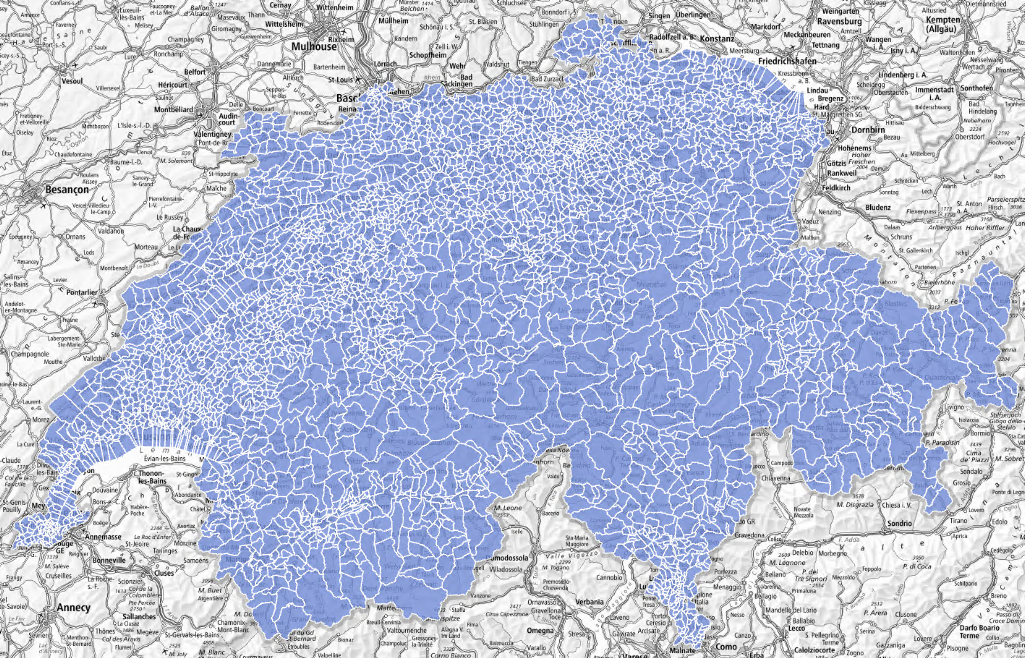
Basic spatial statistical units of the first level (USPAT1)
The first level of basic statistical spatial units (USPAT1) allows a detailed analysis of the territory. These units are stable over time, meaning that they are not affected by municipalities’ mergers. In rural areas, they make it possible to distinguish between urbanized areas which generally have more than 250 inhabitants or more than 250 jobs and 20 establishments or more than 125 dwellings belonging to the same municipality. Urban areas with more than 15 000 inhabitants are further subdivided into urban sectors which
generally have between 7 500 and 15 000 inhabitants.
Simple
- Alternate title
-
Basic statistical units level 1
- Date (Publication)
- 2024-06-28
- Identifier
- ch.bfs.statistische-grundeinheiten_stufe1
- Status
- Completed
Point of contact
- Topic category
-
- D Boundaries
Extent
Extent
- Description
-
Switzerland
))

- Maintenance and update frequency
- Irregular
- Duration of Conservation
- 100
- Appraisal of Archival Value
- N
Resource format
- Title
-
OGC Geopackage (GPKG)
- Date
Resource format
- Title
-
ESRI Shapefile (SHP)
- Date
- Keywords
-
-
Statistik; Grundeinheit
-
- geocat.ch
-
-
opendata.swiss
-
confederation
-
boundary line
-
FSDI Federal Spatial Data Infrastructure
-
Resource specific usage
- Specific usage
-
Kommerzielle Verwendung nur mit separater Vereinbarung
Resource constraints
- Use constraints
- Other restrictions
- Language
- Deutsch
- Character encoding
- UTF8
- Basic Geodata
- false
- Basic Geodata Legal Level
- Federal
- Distribution format
-
-
ESRI Shapefile (SHP)
-
OGC Geopackage (GPKG)
-
Digital transfer options
- OnLine resource
-
Geodaten (GeoPackage, Shapefile)
Digital transfer options
- OnLine resource
-
ch.bfs.statistische-grundeinheiten_stufe1
WMS-FSDI service, layer "Basic statistical units level 1"
Digital transfer options
- OnLine resource
-
ch.bfs.statistische-grundeinheiten_stufe1
WMTS-FSDI service, layer "Basic statistical units level 1"
Digital transfer options
- OnLine resource
-
RESTful API von geo.admin.ch
Digital transfer options
- OnLine resource
-
Vorschau map.geo.admin.ch
Digital transfer options
- OnLine resource
-
Variablenliste
I14Y Interoperability platform
Digital transfer options
- OnLine resource
-
GEOSTAT
GEOSTAT ist das BFS-Kompetenzzentrum für Geoinformation und digitale Bildverarbeitung.
Digital transfer options
- OnLine resource
-
Datenbeschreibung
- Geometric object type
- Surface
- Reference system identifier
- EPSG:2056
Metadata
- Metadata identifier
- 4a2a7766-8a90-45f0-ade4-113cd7e1934e
- Language
- Deutsch
- Character encoding
- UTF8
- Language
- Français
- Character encoding
- UTF8
- Language
- Italiano
- Character encoding
- UTF8
- Language
- English
- Character encoding
- UTF8
- Language
- Rumantsch
- Character encoding
- UTF8
Custodian
Type of resource
- Resource scope
- Dataset
- Metadata linkage
-
https://www.geocat.ch/geonetwork/srv/api/records/4a2a7766-8a90-45f0-ade4-113cd7e1934e
- Date info (Creation)
- 2024-07-01T12:48:19.816Z
- Date info (Revision)
- 2026-06-15T07:48:39.636227Z
Metadata standard
- Title
-
eCH-0271