geocat.ch
Raumbezogene statistische Grundeinheiten der ersten Stufe (USPAT1)
Unités spatiales statistiques de base de premier niveau (USPAT1)
Unità territoriali statistiche di base di primo livello (USPAT1)
Basic spatial statistical units of the first level (USPAT1)
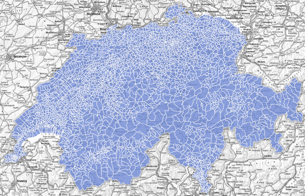
Die raumbezogenen statistischen Grundeinheiten der ersten Stufe (USPAT1) ermöglichen eine Feinanalyse des Territoriums. Sie sind zeitlich stabil, d. h. sie sind nicht von Gemeindefusionen beeinflusst. In ländlichen Regionen bieten sie die Möglichkeit, verschiedene Siedlungsgebiete zu trennen, die in der Regel mehr als 250 Einwohnerinnen und Einwohner oder mehr als 250 Beschäftigte und 20 Arbeitsstätten oder mehr als 125 Wohnungen umfassen, die zu einer einzigen Gemeinde gehören. Städtische Gebiete mit mehr als 15 000 Einwohnerinnen und Einwohner werden zusätzlich in urbane Sektoren unterteilt, die im Allgemeinen zwischen 7 500 und 15 000 Personen umfassen.
Les Unités spatiales statistiques de base de premier niveau (USPAT1) permettent une analyse fine du territoire. Elles sont stables dans le temps, c’est-à-dire qu’elles ne sont pas sensibles aux fusions de communes. Dans les régions rurales, elles donnent l’occasion de séparer différentes zones urbanisées qui comprennent généralement plus de 250 habitants ou plus de 250 emplois et 20 établissements ou plus de 125 logements appartenant à une même commune. Les zones urbaines de plus de 15 000 habitants sont de plus subdivisées en secteurs urbains qui de manière générale comprennent entre 7 500 et 15 000 habitants.
Le unità territoriali statistiche di base di primo livello (USPAT1) consentono un'analisi dettagliata del territorio. Sono stabili nel tempo, il che significa che non sono influenzate da fusioni di Comuni. Nelle aree rurali, offrono l'opportunità di distinguere le diverse aree urbanizzate, che di solito comprendono più di 250 abitanti o più di 250 posti di lavoro e 20 stabilimenti o più di 125 abitazioni appartenenti allo stesso Comune. Le aree urbane con più di 15 000 abitanti sono ulteriormente suddivise in settori urbani che generalmente comprendono tra 7 500 e 15 000 abitanti.
The first level of basic statistical spatial units (USPAT1) allows a detailed analysis of the territory. These units are stable over time, meaning that they are not affected by municipalities’ mergers. In rural areas, they make it possible to distinguish between urbanized areas which generally have more than 250 inhabitants or more than 250 jobs and 20 establishments or more than 125 dwellings belonging to the same municipality. Urban areas with more than 15 000 inhabitants are further subdivided into urban sectors which
generally have between 7 500 and 15 000 inhabitants.
Simple
-
Autre titreAltri nomi o acronimiAlternate titleAlternate titleAlternativtitel
-
Statistische Grundeinheiten Stufe 1
Unités statistiques de base niveau 1
Unità statistiche di base livello 1
Basic statistical units level 1
-
Date (Publication)Data (Pubblicazione)Date (Publication)Date (Publication)Datum (Publikation)
- 2024-06-28
-
IdentifiantIdentificatoreIdentifierIdentifierKennung
- ch.bfs.statistische-grundeinheiten_stufe1
-
ÉtatStatoStatusStatusBearbeitungsstatus
-
TerminéCompletatoCompletedCompletedAbgeschlossen
Point de contact
Punto di contatto
Point of contact
Point of contact
Ansprechpartner
-
Catégorie de thèmeCategoria ISOTopic categoryTopic categoryThematik
-
-
D LimitesD ConfiniD BoundariesD BoundariesD Grenzen
-
Étendue
Estensione
Extent
Extent
Ausdehnung
Étendue
Estensione
Extent
Extent
Ausdehnung
-
DescriptionDescrizioneDescriptionDescriptionBeschreibung
-
Switzerland
Schweiz
Suisse
Svizzera
Svizra
))

-
Fréquence de mise à jourFrequenza di aggiornamentoMaintenance and update frequencyMaintenance and update frequencyWartungsintervall
-
IrrégulièreIrregolareIrregularIrregularUnregelmässig
-
Durée de conservationDurata di conservazioneDuration of ConservationDuration of ConservationAufbewahrungsdauer NV in Jahren
- 100
-
Évaluation de la valeur archivistiqueValutazione del valore archivisticoAppraisal of Archival ValueAppraisal of Archival ValueBewertung Archivwürdigkeit
-
NNNNN
Format de la ressource
Formato della risorsa
Resource format
Resource format
Format der Ressource
-
TitreTitoloTitleTitleTitel
-
OGC Geopackage (GPKG)
-
DateDataDateDateDatum
Format de la ressource
Formato della risorsa
Resource format
Resource format
Format der Ressource
-
TitreTitoloTitleTitleTitel
-
ESRI Shapefile (SHP)
-
DateDataDateDateDatum
- Keywords
-
-
Statistik; Grundeinheit
statistique; unités de base
-
- geocat.ch
-
-
opendata.swiss
opendata.swiss
opendata.swiss
opendata.swiss
-
confédération
confederazione
confederation
-
ligne de frontières
linea di confine
boundary line
-
IFDG l’Infrastructure Fédérale de données géographiques
IFDG Infrastruttura federale dei dati geografici
FSDI Federal Spatial Data Infrastructure
-
Utilisation spécifique de la ressource
Utilizzo specifico della risorsa
Resource specific usage
Resource specific usage
Spezifische Verwendung der Ressource
-
UtilisationUtilizzoSpecific usageSpecific usageVerwendung
-
Kommerzielle Verwendung nur mit separater Vereinbarung
Utilisation commerciale uniquement avec un accord distinct.
Contraintes sur la ressource
Vincoli sulle risorse
Resource constraints
Resource constraints
Ressourcenbeschränkungen
-
Contraintes d'utilisationVincoli d'usoUse constraintsUse constraintsNutzungseinschränkungen
-
Autres restrictionsAltre restrizioniOther restrictionsOther restrictionsAndere Beschränkungen
-
Autres contraintesAltri vincoliOther constraintsOther constraintsAndere Einschränkungen
- Opendata BY ASK: Freie Nutzung. Quellenangabe ist Pflicht. Kommerzielle Nutzung nur mit Bewilligung des Datenlieferanten zulässig.Opendata BY ASK: Utilisation libre. Obligation d’indiquer la source. Utilisation commerciale uniquement avec l’autorisation du fournisseur des données.Opendata BY ASK: Libero utilizzo. Indicazione della fonte obbligatoria. Utilizzo a fini commerciali ammesso soltanto previo consenso del titolare dei dati.Opendata BY ASK: Open use. Must provide the source. Use for commercial purposes requires permission of the data owner.
-
LangueLinguaLanguageLanguageSprache
- Deutsch
-
Encodage de caractèresCodifica dei caratteriCharacter encodingCharacter encodingZeichenkodierung
-
Utf8UTF8UTF8UTF8Utf8
-
Géodonnées de baseGeodati di baseBasic GeodataBasic GeodataGeobasisdaten
- false
-
Niveau des géodonnées de baseLivello legale dei geodati di baseBasic Geodata Legal LevelBasic Geodata Legal LevelGeobasisdatenebene
-
FédéralFederaleFederalFederalNational
-
Format de distributionFormato (codifica)Distribution formatDistribution formatAbgabeformat
-
-
ESRI Shapefile (SHP)
-
OGC Geopackage (GPKG)
-
Options de transfert numérique
Opzioni di trasferimento digitale
Digital transfer options
Digital transfer options
Optionen für die digitale Übertragung
-
Ressource en ligneRisorsa onlineOnLine resourceOnLine resourceOnline
-
Geodaten (GeoPackage, Shapefile)
Options de transfert numérique
Opzioni di trasferimento digitale
Digital transfer options
Digital transfer options
Optionen für die digitale Übertragung
-
Ressource en ligneRisorsa onlineOnLine resourceOnLine resourceOnline
-
ch.bfs.statistische-grundeinheiten_stufe1
WMS-BGDI Dienst, Layer "Statistische Grundeinheiten Stufe 1"Service WMS-IFDG, couche "Unités statistiques de base niveau 1"Servizio WMS-IFDG, strato "Unità statistiche di base livello 1"WMS-FSDI service, layer "Basic statistical units level 1"WMS-BGDI Dienst, Layer "Statistische Grundeinheiten Stufe 1"
Options de transfert numérique
Opzioni di trasferimento digitale
Digital transfer options
Digital transfer options
Optionen für die digitale Übertragung
-
Ressource en ligneRisorsa onlineOnLine resourceOnLine resourceOnline
-
ch.bfs.statistische-grundeinheiten_stufe1
WMTS-BGDI Dienst, Layer "Statistische Grundeinheiten Stufe 1"Service WMTS-IFDG, couche "Unités statistiques de base niveau 1"Servizio WMTS-IFDG, strato "Unità statistiche di base livello 1"WMTS-FSDI service, layer "Basic statistical units level 1"WMTS-BGDI Dienst, Layer "Statistische Grundeinheiten Stufe 1"
Options de transfert numérique
Opzioni di trasferimento digitale
Digital transfer options
Digital transfer options
Optionen für die digitale Übertragung
-
Ressource en ligneRisorsa onlineOnLine resourceOnLine resourceOnline
-
RESTful API von geo.admin.ch
Options de transfert numérique
Opzioni di trasferimento digitale
Digital transfer options
Digital transfer options
Optionen für die digitale Übertragung
-
Ressource en ligneRisorsa onlineOnLine resourceOnLine resourceOnline
-
Vorschau map.geo.admin.ch
Options de transfert numérique
Opzioni di trasferimento digitale
Digital transfer options
Digital transfer options
Optionen für die digitale Übertragung
-
Ressource en ligneRisorsa onlineOnLine resourceOnLine resourceOnline
-
Variablenliste
I14Y-InteroperabilitätsplattformI14Y Plateforme d’interopérabilitéI14Y Piattaforma di interoperabilitàI14Y Interoperability platform
Options de transfert numérique
Opzioni di trasferimento digitale
Digital transfer options
Digital transfer options
Optionen für die digitale Übertragung
-
Ressource en ligneRisorsa onlineOnLine resourceOnLine resourceOnline
-
GEOSTAT
GEOSTAT ist das BFS-Kompetenzzentrum für Geoinformation und digitale Bildverarbeitung.GEOSTAT est le centre de compétence pour la géoinformation et le traitement numérique des images digitales de l'OFS.
Options de transfert numérique
Opzioni di trasferimento digitale
Digital transfer options
Digital transfer options
Optionen für die digitale Übertragung
-
Ressource en ligneRisorsa onlineOnLine resourceOnLine resourceOnline
-
Datenbeschreibung
-
Type d’objet géométriqueTipo di oggetto geometricoGeometric object typeGeometric object typeTyp des geometrischen Objekts
-
PolygoneSuperficieSurfaceSurfacesurface
-
Nom du système de référenceNome del sistema di riferimentoReference system identifierReference system identifierName des Referenzsystems
- EPSG:2056
Metadata
-
Identifiant des métadonnéesIdentificativo della schedaMetadata identifierMetadata identifierIdentifikator des Metadatensatzes
- 4a2a7766-8a90-45f0-ade4-113cd7e1934e
-
LangueLinguaLanguageLanguageSprache
- Deutsch
-
Encodage de caractèresCodifica dei caratteriCharacter encodingCharacter encodingZeichenkodierung
-
Utf8UTF8UTF8UTF8Utf8
-
LangueLinguaLanguageLanguageSprache
- Français
-
Encodage de caractèresCodifica dei caratteriCharacter encodingCharacter encodingZeichenkodierung
-
Utf8UTF8UTF8UTF8Utf8
-
LangueLinguaLanguageLanguageSprache
- Italiano
-
Encodage de caractèresCodifica dei caratteriCharacter encodingCharacter encodingZeichenkodierung
-
Utf8UTF8UTF8UTF8Utf8
-
LangueLinguaLanguageLanguageSprache
- English
-
Encodage de caractèresCodifica dei caratteriCharacter encodingCharacter encodingZeichenkodierung
-
Utf8UTF8UTF8UTF8Utf8
-
LangueLinguaLanguageLanguageSprache
- Rumantsch
-
Encodage de caractèresCodifica dei caratteriCharacter encodingCharacter encodingZeichenkodierung
-
Utf8UTF8UTF8UTF8Utf8
Dépositaire
Custode
Custodian
Custodian
Verwalter
Type de ressource
Tipo di risorsa
Type of resource
Type of resource
Anwendungsbereich der Metadaten
-
Domaine d'application de la ressourceAmbito di applicazione della risorsaResource scopeResource scopeDomäne der Ressourcenanwendung
-
Jeu de donnéesSet di datiDatasetDatasetDatenbestand
-
Lien vers la métadonnéeCollegamento ai metadatiMetadata linkageMetadata linkageLink zu den Metadaten
-
Informations de date (Création)Informazioni sulla data (Creazione)Date info (Creation)Date info (Creation)Datumsangaben (Erstellung)
- 2024-07-01T12:48:19.816Z
-
Informations de date (Révision)Informazioni sulla data (Revisione)Date info (Revision)Date info (Revision)Datumsangaben (Aktualisierung)
- 2026-06-15T07:48:39.636227Z
Norme des métadonnées
Standard dei metadati
Metadata standard
Metadata standard
Metadatenstandard
-
TitreTitoloTitleTitleTitel
-
eCH-0271