geocat.ch
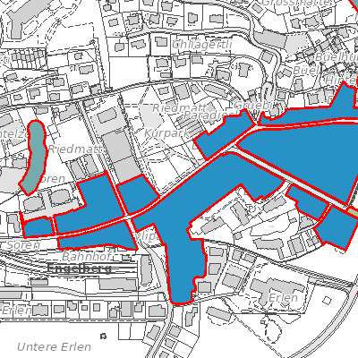
Planungszonen kommunal (Engelberg, OW)
Der Geobasisdatensatz enthält die kommunalen Planungszonen. Die Planungszone bezeichnet ein Gebiet, in dem Nutzungspläne erlassen oder geändert werden müssen.
Simple
- Date (Creation)
- 2020-01-01
- Date (Revision)
- 2025-09-07
- Identifier
- en_planungszone
- Status
- On going
Owner
Folgende Aufgaben gehören in den Zuständigkeitsbereich des Bereichs Bauamt:RaumordnungStrassenKanalisationGewässerEnergiewesenNaturschutzUmwelt- und NaturgefahrenWasserversorgungVerkehrswesenDenkmalpflege
- Hours of service
-
Montag bis Donnerstag 08.30 Uhr bis 11.30 Uhr 13.30 Uhr bis 17.00 Uhr Freitag 08.30 Uhr bis 11.30 Uhr 13.30 Uhr bis 16.30 Uhr
- Spatial representation type
- Vector
- Topic category
-
- E Planning cadastre
Extent
Extent
- Description
-
Engelberg
))

- Maintenance and update frequency
- As needed
- GEMET
-
-
federal law
-
planning
-
land management and planning
-
physical planning
-
zoning
-
- geocat.ch
-
-
planning project
-
zoning plan
-
Resource constraints
- Access constraints
- Other restrictions
- Use constraints
- Other restrictions
- Other constraints
- Die Geodaten sind öffentlich zugänglich (Zugangsberechtigungsstufe A gemäss GeoIV Art. 21).
- Language
- Deutsch
- Character encoding
- UTF8
- Environment description
-
QGIS
- Subtopic Category
- E1 Spatial Planning, Spatial Development
- Basic Geodata
- true
- Basic Geodata ID
-
76>B.1
- Basic Geodata Legal Level
- Bund
- Distribution format
-
-
INTERLIS
-
andere Formate auf Anfrage
-
Distributor
Digital transfer options
- OnLine resource
-
Geoshop OW
Datenbezug
Digital transfer options
- OnLine resource
-
planungszonen
WMS-Dienst geodienste.ch
Digital transfer options
- OnLine resource
-
Geodienste.ch
Datenbezug
Digital transfer options
- OnLine resource
-
ch.ow.planungszonen
WMS-Dienst Kanton Obwalden
Digital transfer options
- OnLine resource
-
Geobasisdatenkatalog
Identifier
- Code
- 2056
Metadata
- Metadata identifier
- 453C4AE1-B1CA-49A0-9A6F-CC4BA86EA835
- Language
- Deutsch
- Character encoding
- UTF8
- Language
- Français
- Character encoding
- UTF8
- Language
- English
- Character encoding
- UTF8
- Language
- Italiano
- Character encoding
- UTF8
Custodian
Type of resource
- Resource scope
- Dataset
- Date info (Revision)
- 2026-05-12T13:10:54.000Z
Metadata standard
- Title
-
GM03_2