geocat.ch
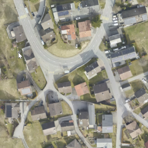
Orthophoto Triesenberg 2024
Orthophoto (RGB, 8-bit per channel, TIFF/TFW and ECW with a pixel size of 6 cm). The aerial survey was carried out in the municipality of Triesenberg for the Office for Civil Protection FL (Digital Terrain Model and Orthophoto for Triesenberg). The specifications of the digital terrain model are as follows: LAZ point cloud in 2 classes (ground points and non-ground points) and interpolated elevation model DTM/DSM with 0.1 m and 1 m grid.
Simple
- Date (Publication)
- 2024-02-21
- Edition
-
2024
- Identifier
- https://metadata.geo.llv.li/41cc6589-accb-4766-a8e8-7a58039c9f8d
- Purpose
-
For the landslide area of Triesenberg / Principality of Liechtenstein, a highly accurate digital terrain model (DTM) and surface model (DSM), as well as a digital orthophoto (DOP), are to be created. The initial survey was carried out in 2024.
- Status
- Completed
Point of contact
- Hours of service
-
8:00-11:30 und 13:30-17:00
Publisher
- Hours of service
-
8:00-11:30 und 13:30-17:00
- Spatial representation type
- Grid
Spatial resolution
- Spatial resolution
- 0.06 m
- Topic category
-
- A Imagery base maps earth cover
Extent
Extent
- Description
-
Triesenberg
))

- Maintenance and update frequency
- As needed
Resource format
- Title
-
GeoTIFF (GEOTIFF)
- Date
- geocat.ch
-
-
digital color orthophoto mosaic
-
orthophoto
-
- GEMET - INSPIRE themes, version 1.0
-
-
Orthoimagery
-
- GEMET themes
-
-
research
-
Resource constraints
- Access constraints
- Other restrictions
- Other constraints
- No limitations to public access
- Language
- Deutsch
- Character encoding
- UTF8
- Subtopic Category
- A1 Base Maps, Landscape Models
- Subtopic Category
- A3 Aerial and Satellite Imagery
- Attribute description
- RGB-Farbwert
- Distribution format
-
-
GeoTIFF (GEOTIFF)
-
Distributor
- Hours of service
-
8:00-11:30 und 13:30-17:00
Digital transfer options
- Units of distribution
-
1 Kachel oder indiv. Ausschnitte
- OnLine resource
-
Homepage ATG, Datenausgabe
data distribution office of the Liechtenstein National Administration
Digital transfer options
- Units of distribution
-
1 Kachel oder indiv. Ausschnitte
- OnLine resource
-
Geodatenportal der Liechtensteinischen Landesverwaltung
Public online maps of the Liechtenstein National Administration
- Hierarchy level
- Dataset
- Statement
-
Aerial survey from an altitude of approx. 2,200m? above ground level
- Hierarchy level
- Dataset
- Description
-
Digitales Geländemodell und Orthophoto für Triesen-berg
- Number of dimensions
- 2
- Cell geometry
- Area
- Transformation parameter availability
- 1
- Reference system identifier
- http://www.opengis.net/def/crs/EPSG/0/2056
- Reference system identifier
- http://www.opengis.net/def/crs/EPSG/0/4936
- Maintenance and update frequency
- As needed
Metadata
- Metadata identifier
- 41cc6589-accb-4766-a8e8-7a58039c9f8d
- Language
- Deutsch
- Character encoding
- UTF8
- Language
- Français
- Character encoding
- UTF8
- Language
- Italiano
- Character encoding
- UTF8
- Language
- English
- Character encoding
- UTF8
Point of contact
- Hours of service
-
8:00-11:30 und 13:30-17:00
Type of resource
- Resource scope
- Dataset
- Metadata linkage
-
https://www.geocat.ch/geonetwork/srv/api/records/41cc6589-accb-4766-a8e8-7a58039c9f8d
- Date info (Creation)
- 2025-10-24T06:07:23.249Z
- Date info (Revision)
- 2026-04-13T09:16:08.292154Z
Metadata standard
- Title
-
eCH-0271