geocat.ch
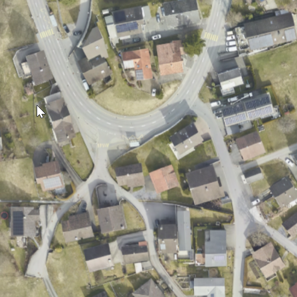
Orthophoto Triesenberg 2024
Orthophoto Triesenberg 2024
Orthophoto (RGB, 8bit pro Kanal, TIFF/TFW und ECW mit einer Pixelgrösse von 6 cm). Die Befliegung wurde im Gemeindegebiet Triesenberg für das Amt für Bevölkerungsschutz FL durchgeführt (Digitales Geländemodell und Orthophoto für Triesenberg). Die spezifikation des digitalen Geländemodelles sind wie folgt: LAZ Punktwolke in 2 Klassen (Bodenpunkte und nicht Bodenpunkte) und interpoliertes Höhenmodell DGM/DOM mit 0.1m und 1m Raster.
Orthophoto (RGB, 8-bit per channel, TIFF/TFW and ECW with a pixel size of 6 cm). The aerial survey was carried out in the municipality of Triesenberg for the Office for Civil Protection FL (Digital Terrain Model and Orthophoto for Triesenberg). The specifications of the digital terrain model are as follows: LAZ point cloud in 2 classes (ground points and non-ground points) and interpolated elevation model DTM/DSM with 0.1 m and 1 m grid.
Simple
-
Date (Publication)Data (Pubblicazione)Date (Publication)Datum (Publikation)
- 2024-02-21
-
ÉditionEdizioneEditionAusgabe
-
2024
-
IdentifiantIdentificatoreIdentifierKennung
- https://metadata.geo.llv.li/41cc6589-accb-4766-a8e8-7a58039c9f8d
-
ButScopoPurposeZweck
-
Für das Rutschgebiet von Triesenberg/Fürstentum Lichtenstein soll ein hochgenaues, digitales Geländemodell (DTM) und Oberflächenmodell (DOM) sowie ein digitales Orthophoto (DOP) er-stellt werden. Die erstmalige Erfassung erfolgte im Jahr 2024.
For the landslide area of Triesenberg / Principality of Liechtenstein, a highly accurate digital terrain model (DTM) and surface model (DSM), as well as a digital orthophoto (DOP), are to be created. The initial survey was carried out in 2024.
-
ÉtatStatoStatusBearbeitungsstatus
-
TerminéCompletatoCompletedAbgeschlossen
Point de contact
Punto di contatto
Point of contact
Ansprechpartner
-
Heures de serviceOrario di servizioHours of serviceBetriebszeiten
-
8:00-11:30 und 13:30-17:00
responsable de la publication
Editore
Publisher
Herausgeber
-
Heures de serviceOrario di servizioHours of serviceBetriebszeiten
-
8:00-11:30 und 13:30-17:00
-
Type de représentation spatialeTipo di rappresentazione spazialeSpatial representation typeRäumliche Darstellungsart
-
grilleRasterGridRaster, Gitter
Résolution spatiale
Risoluzione spaziale
Spatial resolution
Räumliche Auflösung
-
Distance de résolutionDistanza di risoluzioneSpatial resolutionDistanz
- 0.06 m
-
Catégorie de thèmeCategoria ISOTopic categoryThematik
-
-
A Imagerie, cartes de base et occupation du solA Mappe di base con immagini della copertura terrestreA Imagery base maps earth coverA Oberflächenbeschreibung
-
Étendue
Estensione
Extent
Ausdehnung
Étendue
Estensione
Extent
Ausdehnung
-
DescriptionDescrizioneDescriptionBeschreibung
-
Triesenberg
Triesenberg
Triesenberg
Triesenberg
))

-
Fréquence de mise à jourFrequenza di aggiornamentoMaintenance and update frequencyWartungsintervall
-
Comme nécessaireSecondo necessitàAs neededBei Bedarf
Format de la ressource
Formato della risorsa
Resource format
Format der Ressource
-
TitreTitoloTitleTitel
-
GeoTIFF (GEOTIFF)
-
DateDataDateDatum
- geocat.ch
-
-
mosaïque d'orthophotos numériques en couleur
mosaico di ortofoto digitali a colori
digital color orthophoto mosaic
-
orthophoto
ortofoto
orthophoto
-
- GEMET - INSPIRE themes, version 1.0
-
-
Ortho-imagerie
Orto immagini
Orthoimagery
-
- GEMET themes
-
-
recherche
ricerca
research
-
- Räumlicher Anwendungsbereich
-
-
Local
Locali
Local
-
Contraintes sur la ressource
Vincoli sulle risorse
Resource constraints
Ressourcenbeschränkungen
-
Contraintes d'accèsVincoli di accessoAccess constraintsZugriffsbeschränkungen
-
Autres restrictionsAltre restrizioniOther restrictionsAndere Beschränkungen
-
Autres contraintesAltri vincoliOther constraintsAndere Einschränkungen
- No limitations to public accessNo limitations to public accessNo limitations to public accessNo limitations to public access
-
LangueLinguaLanguageSprache
- Deutsch
-
Encodage de caractèresCodifica dei caratteriCharacter encodingZeichenkodierung
-
Utf8UTF8UTF8Utf8
-
Catégorie de sous-thèmeCategoria di sottotemaSubtopic CategoryThematische Unterkategorien
-
A1 Cartes de base, modèles de paysageA1 Mappe di base, modelli paesaggisticiA1 Base Maps, Landscape ModelsA1 Basiskarten, Landschaftsmodelle
-
Catégorie de sous-thèmeCategoria di sottotemaSubtopic CategoryThematische Unterkategorien
-
A3 Images aériennes, satellitesA3 Immagini aeree e satellitariA3 Aerial and Satellite ImageryA3 Luft-, Satellitenbilder
-
Description de l'attributDescrizione dell'attributoAttribute descriptionBeschreibung des Attributs
- RGB-Farbwert
-
Format de distributionFormato (codifica)Distribution formatAbgabeformat
-
-
GeoTIFF (GEOTIFF)
-
Distributeur
Distributore
Distributor
Verteiler
-
Heures de serviceOrario di servizioHours of serviceBetriebszeiten
-
8:00-11:30 und 13:30-17:00
Options de transfert numérique
Opzioni di trasferimento digitale
Digital transfer options
Optionen für die digitale Übertragung
-
Unités de distributionUnità di distribuzioneUnits of distributionVerteilungseinheiten
-
1 Kachel oder indiv. Ausschnitte
-
Ressource en ligneRisorsa onlineOnLine resourceOnline
-
Homepage ATG, Datenausgabe
Datenausgabestelle der Liechtensteinischen Landesverwaltungdata distribution office of the Liechtenstein National Administration
Options de transfert numérique
Opzioni di trasferimento digitale
Digital transfer options
Optionen für die digitale Übertragung
-
Unités de distributionUnità di distribuzioneUnits of distributionVerteilungseinheiten
-
1 Kachel oder indiv. Ausschnitte
-
Ressource en ligneRisorsa onlineOnLine resourceOnline
-
Geodatenportal der Liechtensteinischen Landesverwaltung
Öfftentliche Online-Karten der Liechtensteinischen LandesverwaltungPublic online maps of the Liechtenstein National Administration
-
NiveauLivelloHierarchy levelBezugsebene
-
Jeu de donnéesSet di datiDatasetDatenbestand
-
Généralités sur la provenanceInformazioni generali sulla provenienzaStatementErklärung
-
Luftbildbefliegung aus einer Flughöhe von 460- 760m über Grund
Aerial survey from an altitude of approx. 2,200m? above ground level
-
NiveauLivelloHierarchy levelBezugsebene
-
Jeu de donnéesSet di datiDatasetDatenbestand
-
DescriptionDescrizioneDescriptionBeschreibung
-
Digitales Geländemodell und Orthophoto für Triesen-berg
-
Nombre de dimensionsNumero di dimensioniNumber of dimensionsAnzahl der Dimensionen
- 2
-
Géométrie de la celluleGeometria della cellaCell geometryZellgeometrie
-
SurfaceAreaAreaFläche
-
Disponibilité des paramètres de transformationDisponibilità dei parametri di trasformazioneTransformation parameter availabilityVerfügbarkeit der Transformationsparameter
- 1
-
Nom du système de référenceNome del sistema di riferimentoReference system identifierName des Referenzsystems
- http://www.opengis.net/def/crs/EPSG/0/2056
-
Nom du système de référenceNome del sistema di riferimentoReference system identifierName des Referenzsystems
- http://www.opengis.net/def/crs/EPSG/0/4936
-
Fréquence de mise à jourFrequenza di aggiornamentoMaintenance and update frequencyWartungsintervall
-
Comme nécessaireSecondo necessitàAs neededBei Bedarf
Metadata
-
Identifiant des métadonnéesIdentificativo della schedaMetadata identifierIdentifikator des Metadatensatzes
- 41cc6589-accb-4766-a8e8-7a58039c9f8d
-
LangueLinguaLanguageSprache
- Deutsch
-
Encodage de caractèresCodifica dei caratteriCharacter encodingZeichenkodierung
-
Utf8UTF8UTF8Utf8
-
LangueLinguaLanguageSprache
- Français
-
Encodage de caractèresCodifica dei caratteriCharacter encodingZeichenkodierung
-
Utf8UTF8UTF8Utf8
-
LangueLinguaLanguageSprache
- Italiano
-
Encodage de caractèresCodifica dei caratteriCharacter encodingZeichenkodierung
-
Utf8UTF8UTF8Utf8
-
LangueLinguaLanguageSprache
- English
-
Encodage de caractèresCodifica dei caratteriCharacter encodingZeichenkodierung
-
Utf8UTF8UTF8Utf8
Point de contact
Punto di contatto
Point of contact
Ansprechpartner
-
Heures de serviceOrario di servizioHours of serviceBetriebszeiten
-
8:00-11:30 und 13:30-17:00
Type de ressource
Tipo di risorsa
Type of resource
Anwendungsbereich der Metadaten
-
Domaine d'application de la ressourceAmbito di applicazione della risorsaResource scopeDomäne der Ressourcenanwendung
-
Jeu de donnéesSet di datiDatasetDatenbestand
-
Informations de date (Création)Informazioni sulla data (Creazione)Date info (Creation)Datumsangaben (Erstellung)
- 2025-10-24T06:07:23.249Z
-
Informations de date (Révision)Informazioni sulla data (Revisione)Date info (Revision)Datumsangaben (Aktualisierung)
- 2026-04-13T09:16:08.292154Z
Norme des métadonnées
Standard dei metadati
Metadata standard
Metadatenstandard
-
TitreTitoloTitleTitel
-
eCH-0271