 geocat.ch
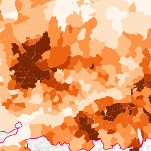
Population communale du Rhin Supérieur (2020)
Gemeindebevölkerung am Oberrhein (2020)
Municipal population in the Upper Rhine (2020)
Cette donnée représente le nombre d'habitants par commune sur le territoire du Rhin Supérieur. Les données allemandes et suisses datent de 2020 et les données françaises de 2019.
Diese Daten stellen die Anzahl der Einwohner pro Kommune auf dem Gebiet des Oberrheins dar. Die deutschen und schweizerischen Daten stammen aus dem Jahr 2020, die französischen Daten aus dem Jahr 2019.
This data represents the number of inhabitants per municipality in the Upper Rhine area. The German and Swiss data are from 2020 and the French data from 2019.
Simple
-
Datum (Erstellung)Date (Creation)Date (Création)
- 2022-09-02
-
Datum (Publikation)Date (Publication)Date (Publication)
- 2023-02-20
-
KennungIdentifierIdentifiant
- population_communale_2020
-
BearbeitungsstatusStatusÉtat
-
AbgeschlossenCompletedTerminé
Kontakt für die Ressource
Point of contact
Contact pour la ressource
-
mri:deliveryPointmri:deliveryPointmri:deliveryPoint
-
100, avenue d'Alsace
100, avenue d'Alsace
-
mri:citymri:citymri:city
-
COLMAR
-
mri:postalCodemri:postalCodemri:postalCode
-
68000
-
mri:countryCountrymri:country
-
FRANCE
FRANCE
-
Räumliche DarstellungsartSpatial representation typeType de représentation spatiale
-
VektorVectorvecteur
Räumliche Auflösung
Spatial resolution
Résolution spatiale
Vergleichsmassstab
Equivalent scale
Fraction représentative
-
MassstabszahlDenominatorDénominateur
- 50000
-
ThematikTopic categoryCatégorie de thème
-
-
D GrenzenD BoundariesD Limites
-
Ausdehnung
Extent
Étendue
Ausdehnung
Extent
Étendue
Zeitlicher Umfang
Temporal extent
Étendue temporelle
-
ZeitraumTime periodPériode
- 2019-01-01 2020-12-31
Ausdehnung
Extent
Étendue
Ausdehnung
Extent
Étendue
))
-
WartungsintervallMaintenance and update frequencyFréquence de mise à jour
-
Bei BedarfAs neededComme nécessaire
- Keywords
-
-
Données ouvertes
Open-Data
Open-Data
-
-
OrtPlacePosition
-
-
Rhin Supérieur
Oberrhein
Upper Rhine
-
- GEMET - INSPIRE themes, version 1.0
-
-
Unités statistiques
Statistische Einheiten
Statistical units
-
Dénominations géographiques
Geografische Bezeichnungen
Geographical names
-
Unités administratives
Verwaltungseinheiten
Administrative units
-
- GEMET - Concepts, version 2.4
-
-
limite administrative
Verwaltungsgrenze
administrative boundary
-
commune
Gemeinde
municipality
-
données statistiques
Statistische Daten
statistical data
-
démographie
Demographie
demography
-
Ressourcenbeschränkungen
Resource constraints
Contraintes sur la ressource
-
NutzungsbeschränkungUse limitationLimitation d'utilisation
-
Licence CC-BY ©GeoRhena ; ©GT Statistiques de la Conférence du Rhin Supérieur ; ©INSEE ; ©OFS ; ©STALA BW ; ©STALA RP
CC-BY Lizenz ©GeoRhena ; ©AG Statistik der Oberrheinkonferenz ; ©INSEE ; ©OFS ; ©STALA BW ; ©STALA RP
License CC-BY ©GeoRhena ; ©WG Statistics of the Upper Rhine Conference ; ©INSEE ; ©OFS ; ©STALA BW ; ©STALA R
-
SpracheLanguageLangue
- Français
-
ZeichenkodierungCharacter encodingEncodage de caractères
-
Utf8UTF8Utf8
-
AbgabeformatDistribution formatFormat de distribution
-
-
Géodonnée au format SHP
GeoDatei im SHP Format
SHP GeoData
-
Optionen für die digitale Übertragung
Digital transfer options
Options de transfert numérique
-
OnlineOnLine resourceRessource en ligne
-
population_communale_2020
Population communale (2020)Gemeindebevölkerung (2020)
Optionen für die digitale Übertragung
Digital transfer options
Options de transfert numérique
-
OnlineOnLine resourceRessource en ligne
-
society:population_communale_2020
Population communale (2020)Gemeindebevölkerung (2020)
Optionen für die digitale Übertragung
Digital transfer options
Options de transfert numérique
-
OnlineOnLine resourceRessource en ligne
-
Téléchargement du Shapefile
Téléchargement du Shapefile
Téléchargement du Shapefile
-
ErklärungStatementGénéralités sur la provenance
-
Données provenant des différents instituts statistiques des trois pays : Statistisches Landesamt Baden-Württemberg (STALA BW) et Statistische Landesamt Rheinland-Pfalz (STALA RP) pour l'Allemagne, Office fédéral de la statistique (OFS) pour la Suisse et l'Institut national de la statistique et des études économiques (INSEE) pour la France.
Daten von den verschiedenen statistischen Ämtern der drei Länder: Statistisches Landesamt Baden-Württemberg (STALA BW) und Statistisches Landesamt Rheinland-Pfalz (STALA RP) für Deutschland, Bundesamt für Statistik (BFS) für die Schweiz und das Institut national de la statistique et des études économiques (INSEE) für Frankreich.
Data from the different statistical institutes of the three countries: Statistisches Landesamt Baden-Württemberg (STALA BW) and Statistische Landesamt Rheinland-Pfalz (STALA RP) for Germany, the Federal Statistical Office (FSO) for Switzerland and the Institut national de la statistique et des études économiques (INSEE) for France
-
BezugsebeneHierarchy levelNiveau
-
DatenbestandDatasetJeu de données
Metadata
-
Identifikator des MetadatensatzesMetadata identifierIdentifiant des métadonnées
- 3ea1f7f7-e08b-4f09-bab7-2b86c96b6cf1
-
SpracheLanguageLangue
- Français
-
ZeichenkodierungCharacter encodingEncodage de caractères
-
Utf8UTF8Utf8
-
SpracheLanguageLangue
- Deutsch
-
ZeichenkodierungCharacter encodingEncodage de caractères
-
Utf8UTF8Utf8
-
SpracheLanguageLangue
- English
-
ZeichenkodierungCharacter encodingEncodage de caractères
-
Utf8UTF8Utf8
Kontaktstelle für Metadaten
Contact
Point de contact des métadonnées
Anwendungsbereich der Metadaten
Type of resource
Type de ressource
-
Domäne der RessourcenanwendungResource scopeDomaine d'application de la ressource
-
DatenbestandDatasetJeu de données
-
Datumsangaben (Aktualisierung)Date info (Revision)Informations de date (Révision)
- 2025-03-14T16:04:11.458057Z
Metadatenstandard
Metadata standard
Norme des métadonnées
-
TitelTitleTitre
-
ISO 19115-3:2018
-
AusgabeEditionÉdition
-
1.0
Overviews
Spatial extent
)))