geocat.ch
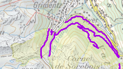
Bewilligte Routen (Wildruhezonen)
Bewilligte Zufahrten in den Wildruhezonen
Simple
- Alternate title
-
Bewilligte Routen
- Date (Creation)
- 2014-10-13
- Date (Revision)
- 2024-10-23
- Identifier
- 358
- Purpose
-
Information über die bewilligten Zufahrten
- Status
- Completed
Custodian
- Spatial representation type
- Vector
Spatial resolution
Equivalent scale
- Denominator
- 25000
- Topic category
-
- L Environment
Extent
Extent
- Description
-
Canton of Valais (VS)
))

- Maintenance and update frequency
- userDefined
- Maintenance note
-
Alle 5 Jahre
Resource format
- Title
-
ESRI Enterprise Geodatabase
- Date
- GEMET themes
-
-
natural dynamics
-
- GEMET - INSPIRE themes, version 1.0
-
-
Habitats and biotopes
-
- GEMET
-
-
wild animal
-
- GEMET
-
-
fauna
-
- geocat.ch
-
-
opendata.swiss
-
official geodata
-
Resource constraints
- Use limitation
-
keine
Resource constraints
- Access constraints
- Other restrictions
- Other constraints
-
Die Geodaten sind öffentlich zugänglich. (Zugangsberechtigungsstufe A nach KGeoIG)
- Other constraints
-
Es gelten die Nutzungsbedingungen für Geodaten des Kantons Wallis ( https://www.vs.ch/de/web/guest/rechtliches).
Associated resource
- Association Type
- Reference from one resource to another
- Metadata Reference
- Language
- Français
- Character encoding
- UTF8
- Environment description
-
S:\Geodaten VS\L2 Natur- und Landschaftsschutz\Bewilligte Routen (Wildruhezonen).lyr
- Subtopic Category
- L2 Nature and Landscape Protection
- Basic Geodata
- true
- Basic Geodata ID
-
195>A
- Basic Geodata Legal Level
- Cantonal
- Basic Geodata Type
- basicGeodata
- Distribution format
-
-
ESRI Shapefile (SHP)
-
OGC Web Map Service (WMS)
-
ArcGIS REST Feature Service
-
Distributor
Digital transfer options
- OnLine resource
-
Geoportal Kanton Wallis
Digital transfer options
- OnLine resource
-
OpenData Wallis
OpenData Wallis - Portal zum herunterladen von Geodaten des Kantons Wallis : Mutiformat und WebMercator
Digital transfer options
- OnLine resource
-
Landing Page
Landing Page für opendata
Digital transfer options
- OnLine resource
-
geodienste.ch das interkantonale Portal
Download von modellkonforme Geodaten (verschiedene Formate)
Digital transfer options
- OnLine resource
-
Permalink opendata.swiss
Permalink opendata.swiss
Digital transfer options
- OnLine resource
-
3
Wildtierschutz_Bewilligte Routen Wildruhezonen
Digital transfer options
- OnLine resource
-
acces_autorisé
Bewilligte Zufahrten in den Wildruhezonen
- Statement
-
Digitalisierung auf der Grundlage von Swiss Map Raster 25
- Hierarchy level
- Dataset
- Description
-
Digitalisierung
Equivalent scale
- Denominator
- 25000
- Geometric object type
- Curve
- Geometric object count
- 20
- Reference system identifier
- EPSG:2056/CH1903+_LV95
Metadata
- Metadata identifier
- 3dbc8db5-a492-48d5-b634-9a7b8cef524f
- Language
- Deutsch
- Character encoding
- UTF8
- Language
- Français
- Character encoding
- UTF8
- Language
- Italiano
- Character encoding
- UTF8
- Language
- English
- Character encoding
- UTF8
- Language
- Rumantsch
- Character encoding
- UTF8
Distributor
Type of resource
- Resource scope
- Dataset
- Metadata linkage
-
https://www.geocat.ch/geonetwork/srv/api/records/3dbc8db5-a492-48d5-b634-9a7b8cef524f
- Date info (Creation)
- 2020-01-10T09:35:45Z
- Date info (Revision)
- 2026-04-13T09:34:35.818462Z
Metadata standard
- Title
-
eCH-0271