geocat.ch
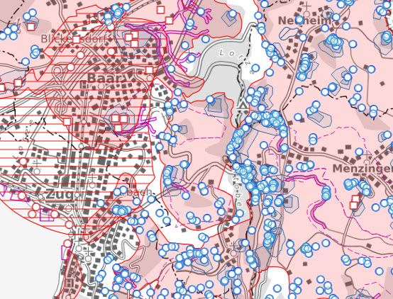
Gewässerschutzkarte - planerischer Gewässerschutz (ZG)
Die Gewässerschutzkarte mit den darin aufgeführten besonders gefährdeten Gewässerschutzbereichen, Grundwasserschutzzonen und -arealen dient der nachhaltigen Bewirtschaftung der natürlichen Wasserressourcen. Sie ist damit das entscheidende planerische Instrument für den planerischen Gewässerschutz und wird von den Kantonen erstellt.
Simple
- Date (Revision)
- 2025-12-19
- Date (Creation)
- 2025-12-19
- Status
- On going
Owner
- Spatial representation type
- Vector
- Topic category
-
- I Inland waters
Extent
Extent
- Description
-
Canton of Zug (ZG)
))

- Maintenance and update frequency
- As needed
Resource format
- Title
-
INTERLIS 1 (ITF)
- Date
- GEMET
-
-
groundwater protection
-
human population
-
groundwater
-
water (geographic)
-
water conservation
-
resource utilisation
-
- geocat.ch
-
-
OpenData
-
construction zone
-
structural planning
-
groundwater protection area
-
land use planning
-
water protection sector
-
opendata.swiss
-
- geocat.ch
-
-
protection zone
-
Associated resource
- Association Type
- Reference to a master resource of which this one is a part
- Metadata Reference
- Language
- Deutsch
- Character encoding
- UTF8
- Distribution format
-
-
OGC Web Feature Service (WFS)
-
AutoCAD DXF (DXF)
-
OGC Geopackage (GPKG)
-
INTERLIS
-
ESRI Shapefile (SHP)
-
Digital transfer options
- OnLine resource
-
Gewässerschutzkarte (ZugMap)
ZugMap, der öffentliche Geodaten-Viewer des GIS Kanton Zug
- OnLine resource
-
KGDM ZG Gewässerschutzkarte (Shapefile)
KGDM ZG Gewässerschutzkarte (Shapefile)
- OnLine resource
-
KGDM ZG Gewässerschutzkarte (INTERLIS)
KGDM ZG Gewässerschutzkarte (INTERLIS)
- OnLine resource
-
KGDM ZG Gewässerschutzkarte (DXF)
KGDM ZG Gewässerschutzkarte (DXF)
- OnLine resource
-
KGDM ZG Gewässerschutzkarte (GeoPackage)
KGDM ZG Gewässerschutzkarte (GeoPackage)
- OnLine resource
-
MGDM Gewässerschutzkarte (INTERLIS)
- OnLine resource
-
MGDM Gewässerschutzkarte (Geopackage)
- OnLine resource
-
MGDM Gewässerschutzkarte (Shapefile)
- OnLine resource
-
MGDM Gewässerschutzkarte (OGC API Features)
OGC API Features
Digital transfer options
- OnLine resource
-
MGDM Gewässerschutzkarte (WMS)
MGDM Gewässerschutzkarte (WMS)
Digital transfer options
- OnLine resource
-
MGDM Gewässerschutzkarte (WFS)
MGDM Gewässerschutzkarte (WFS)
Digital transfer options
- OnLine resource
-
KGDM ZG Gewässerschutzkarte (WMS)
KGDM ZG Gewässerschutzkarte (WMS)
Digital transfer options
- OnLine resource
-
KGDM ZG Gewässerschutzkarte (WFS)
KGDM ZG Gewässerschutzkarte (WFS)
Digital transfer options
- OnLine resource
-
Hydrogeologische Objekte Gewässerschutzkarte (WMS)
Hydrogeologische Objekte Gewässerschutzkarte (WMS)
Digital transfer options
- OnLine resource
-
Hydrogeologische Objekte Gewässerschutzkarte (WFS)
Hydrogeologische Objekte Gewässerschutzkarte (WFS)
Metadata
- Metadata identifier
- 3d2981af-d5db-4122-8db6-1ea41ed44b3f
- Language
- Deutsch
- Character encoding
- UTF8
- Language
- Français
- Character encoding
- UTF8
- Language
- Italiano
- Character encoding
- UTF8
- Language
- English
- Character encoding
- UTF8
Distributor
Type of resource
- Resource scope
- Dataset
- Metadata linkage
-
https://www.geocat.ch/geonetwork/srv/api/records/3d2981af-d5db-4122-8db6-1ea41ed44b3f
- Date info (Creation)
- 2009-05-28T12:00:00Z
- Date info (Revision)
- 2026-06-12T12:10:44.78321Z
Metadata standard
- Title
-
eCH-0271