geocat.ch
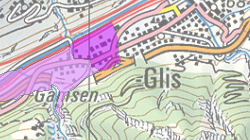
Zones avérées de pollution des sols
Régions dans lesquelles les sols sont pollués et doivent être analysés avant décapage.
Simple
- Alternate title
-
Zones avérées de pollution des sols
- Date (Creation)
- 2016-01-01
- Identifier
- 564
- Purpose
-
Planification des projets de construction
- Status
- On going
Custodian
- Spatial representation type
- Vector
Spatial resolution
Equivalent scale
- Denominator
- 10000
- Topic category
-
- L Environment
- F Geoscientific information
Extent
Extent
- Description
-
Canton of Valais (VS)
))

- Maintenance and update frequency
- As needed
Resource format
- Title
-
ESRI Enterprise Geodatabase
- Date
- GEMET - INSPIRE themes, version 1.0
-
-
Area management/restriction/regulation zones and reporting units
-
- GEMET - INSPIRE themes, version 1.0
-
-
Human health and safety
-
- GEMET
-
-
pollutant
-
soil pollutant
-
degradation of the environment
-
Resource constraints
- Use limitation
-
Aucunes
- Language
- Français
- Character encoding
- UTF8
- Language
- Deutsch
- Character encoding
- UTF8
- Environment description
-
S:\Géodonnées VS\Q2 Systèmes eaux et déchets\Zones avérées de pollution des sols.lyr
- Subtopic Category
- L1 Environmental Protection, Noise
- Subtopic Category
- F2 Soils
- Included with dataset
- true
- Title
-
Zones avérées de pollution des sols - Catalogue d'objets
- Date (Creation)
- 2023-02-22
- Distribution format
-
-
ESRI Shapefile (SHP)
-
OGC Web Map Service (WMS)
-
ArcGIS REST Feature Service
-
Distributor
Digital transfer options
- OnLine resource
-
Géoportail du Canton du Valais
Géoportail du Canton du Valais
Digital transfer options
- OnLine resource
-
26
SP_Zones avérées de pollution des sols
Digital transfer options
- OnLine resource
-
sites_pollues_ZonesAvereesPollsSol
Zones avérées de pollution des sols
- Statement
-
Générée par le SEN sur la base de pollutions identifiées, d'analyses des sols et du mode de dispersion des polluants
- Hierarchy level
- Dataset
- Description
-
Digitalisation
- Geometric object type
- Surface
- Geometric object count
- 3
- Reference system identifier
- EPSG:2056/CH1903+_MN95
- Title
-
Zones avérées de pollution des sols - Modèle de représentation
- Date (Publication)
- 2023-02-22
Metadata
- Metadata identifier
- 3be3f7c3-bfc5-492c-860e-b0127420957c
- Language
- Français
- Character encoding
- UTF8
- Language
- Deutsch
- Character encoding
- UTF8
- Language
- Italiano
- Character encoding
- UTF8
- Language
- English
- Character encoding
- UTF8
- Language
- Rumantsch
- Character encoding
- UTF8
Distributor
Type of resource
- Resource scope
- Dataset
- Metadata linkage
-
https://www.geocat.ch/geonetwork/srv/api/records/3be3f7c3-bfc5-492c-860e-b0127420957c
- Date info (Creation)
- 2023-04-11T11:37:24.334Z
- Date info (Revision)
- 2026-05-11T14:36:22.848766Z
Metadata standard
- Title
-
eCH-0271