geocat.ch
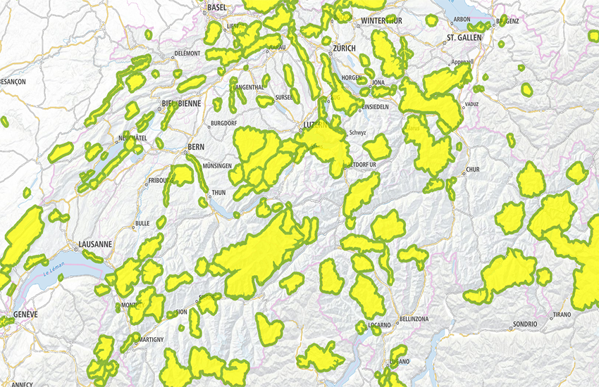
swissTLMRegio Protected Areas
Territorial boundaries: Boundaries of protected areas in Switzerland and in neighbouring countries.
Simple
- Alternate title
-
Protected Areas swissTLMRegio
- Date (Publication)
- 2012-02-24
- Date (Revision)
- 2025-12-02
- Identifier
- ch.swisstopo.vec200-adminboundaries-protectedarea
- Other citation details
-
Part of the swissTLMRegio dataset
- Status
- Completed
Point of contact
- Spatial representation type
- Vector
Spatial resolution
Equivalent scale
- Denominator
- 200000
- Topic category
-
- D Boundaries
Extent
Extent
- Description
-
swissTLMRegio
Identifier
- Code
))

- Maintenance and update frequency
- Annually
- Hierarchy level
- Dataset
- GEMET
-
-
national park
-
protected area
-
geographic information system
-
border
-
- geocat.ch
-
-
GIS (Geographic Information System)
-
landscape model
-
opendata.swiss
-
- GEMET - INSPIRE themes, version 1.0
-
-
Protected sites
-
- geocat.ch
-
-
FSDI Federal Spatial Data Infrastructure
-
Associated resource
- Association Type
- Reference to a master resource of which this one is a part
- Metadata Reference
Associated resource
- Title
-
Topografisches Landschaftsmodell (Landesvermessung)
- Association Type
- Reference to a master resource of which this one is a part
- Language
- English
- Character encoding
- UTF8
- Language
- Deutsch
- Character encoding
- UTF8
- Supplemental Information
-
Die Topics Transportation, Hydrography, Landcover, Buildings, Points of interest und Administrative boundaries bilden zusammen den Datensatz swissTLMRegio.
- Basic Geodata
- true
- Basic Geodata ID
-
38.11
- Basic Geodata Legal Level
- Federal
- Distribution format
-
-
AutoCAD DXF (DXF)
-
ESRI Shapefile (SHP)
-
INTERLIS 2 (XTF)
-
ESRI File Geodatabase FileGDB (GDB)
-
OGC Geopackage (GPKG)
-
Digital transfer options
- OnLine resource
-
Vorschau map.geo.admin.ch
Preview map.geo.admin.ch
Digital transfer options
- OnLine resource
-
ch.swisstopo.vec200-adminboundaries-protectedarea
WMS-FSDI service, layer "Protected Areas swissTLMRegio"
Digital transfer options
- OnLine resource
-
ch.swisstopo.vec200-adminboundaries-protectedarea
WMTS-FSDI service, layer "Protected Areas swissTLMRegio"
Digital transfer options
Digital transfer options
Digital transfer options
Digital transfer options
- OnLine resource
-
RESTful API von geo.admin.ch
RESTful API from geo.admin.ch
- Statement
-
Based on a 1:200 000 scale. Geometric precision: 20-60 m.
- Hierarchy level
- Dataset
- Topology level
- Full planar graph
- Geometric object type
- Surface
- Geometric object count
- 219
- Reference system identifier
- EPSG:21781
- Reference system identifier
- EPSG:2056
- Maintenance and update frequency
- Annually
- Date
- 2026-10-15
- Date type
- nextUpdate
Metadata
- Metadata identifier
- 37c78660-531a-404c-86f8-8cdde0c3d985
- Language
- Deutsch
- Character encoding
- UTF8
- Language
- Français
- Character encoding
- UTF8
- Language
- Italiano
- Character encoding
- UTF8
- Language
- English
- Character encoding
- UTF8
- Language
- Rumantsch
- Character encoding
- UTF8
Point of contact
Type of resource
- Resource scope
- Tile
- Name
-
Topic
- Metadata linkage
-
https://www.geocat.ch/geonetwork/srv/api/records/37c78660-531a-404c-86f8-8cdde0c3d985
- Date info (Creation)
- 2012-04-12T08:27:42Z
- Date info (Revision)
- 2026-04-13T09:13:04.061169Z
Metadata standard
- Title
-
eCH-0271