geocat.ch
swissALTI3D Reliefschattierung monodirektional
swissALTI3D estompage du relief monodirectionnel
swissALTI3D ombreggiatura del rilievo monodirezionale
swissALTI3D monodirectional Hillshade
swissALTI3D sumbriva dal reliev monodirecziunal
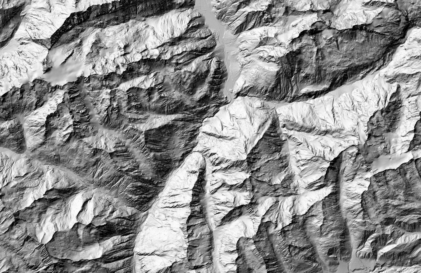
Die Reliefschattierung ist ein Derivat aus dem digitalen Höhenmodell swissALTI3D. Es erlaubt die Visualisierung des Reliefs der Schweiz und des Fürstentums Liechtenstein. Die Reliefschattierung ist ein digitales Schummerungsbild bei einem oder mehreren berechneten Lichteinfällen. Die Darstellung der monodirektionalen Reliefschattierung aus swissALTI3D wurde mit einem nordwestlichen Sonnenstand berechnet.
Représentation dérivée du modèle altimétrique numérique swissALTI3D qui permet de visualiser le relief de la Suisse et de la Principauté de Liechtenstein. L'estompage du relief représente l'illumination d'une surface par une ou plusieurs positions données du soleil. L'estompage de relief monodirectionnel de swissALTI3D a été calculé avec une position solaire au nord-ouest.
Rappresentazione derivata dal modello altimetrico digitale swissALTI3D che permette di visualizzare il rilievo della Svizzera e del Principato del Liechtenstein. L'ombreggiatura del rilievo rappresenta l'illuminazione di una superficie da parte di una o più posizioni date del sole. L'ombreggiatura del rilievo monodirezionale di swissALTI3D è stata calcolata con la posizione solare a nord-ovest.
The hillshade is derived from the digital elevation model swissALTI3D. It illustrates the surface relief of Switzerland and the Principality of Liechtenstein. A hillshade is derived from the elevation model by calculating the exposure of the surface to sunlight at a certain or several angles. The monodirectional swissALTI3D hillshade is generated using a northwestern sun position as light source.
La sumbriva dal reliev deriva dal model digital da l'autezza swissALTI3D. Ella permetta da visualisar il reliev da la Svizra e dal Principadi da Liechtenstein. La sumbriva dal reliev è in maletg digital sumbrivà cun ina u cun pliras incidenzas da la glisch calculadas. Per represchentar la sumbriva dal reliev monodirecziunala da swissALTI3D èsi vegnì calculà cun ina posiziun dal sulegl da nordvest.
Simple
-
Autre titreAltri nomi o acronimiAlternate titleAlternate titleAlternativtitel
-
swissALTI3D monodirektionales Relief
swissALTI3D relief monodirectionnel
swissALTI3D rilievo monodirezionale
swissALTI3D monodirectional hillshade
swissALTI3D reliev monodirecziunal
-
Date (Publication)Data (Pubblicazione)Date (Publication)Date (Publication)Datum (Publikation)
- 2011-03-28
-
Date (Révision)Data (Revisione)Date (Revision)Date (Revision)Datum (Aktualisierung)
- 2017-03-15
-
Date (Révision)Data (Revisione)Date (Revision)Date (Revision)Datum (Aktualisierung)
- 2020-05-12
-
IdentifiantIdentificatoreIdentifierIdentifierKennung
- ch.swisstopo.swissalti3d-reliefschattierung_monodirektional
Point de contact
Punto di contatto
Point of contact
Point of contact
Ansprechpartner
-
Type de représentation spatialeTipo di rappresentazione spazialeSpatial representation typeSpatial representation typeRäumliche Darstellungsart
-
grilleRasterGridGridRaster, Gitter
Résolution spatiale
Risoluzione spaziale
Spatial resolution
Spatial resolution
Räumliche Auflösung
-
Distance de résolutionDistanza di risoluzioneSpatial resolutionSpatial resolutionDistanz
- 0.5 m
-
Catégorie de thèmeCategoria ISOTopic categoryTopic categoryThematik
-
-
C ÉlévationC AltitudineC ElevationC ElevationC Höhenangaben
-
Étendue
Estensione
Extent
Extent
Ausdehnung
Étendue
Estensione
Extent
Extent
Ausdehnung
-
DescriptionDescrizioneDescriptionDescriptionBeschreibung
-
Switzerland
Schweiz
Suisse
Svizzera
Svizra
))

Étendue
Estensione
Extent
Extent
Ausdehnung
Étendue
Estensione
Extent
Extent
Ausdehnung
-
DescriptionDescrizioneDescriptionDescriptionBeschreibung
-
Liechtenstein
Liechtenstein
Liechtenstein
Liechtenstein
Liechtenstein
))

-
Fréquence de mise à jourFrequenza di aggiornamentoMaintenance and update frequencyMaintenance and update frequencyWartungsintervall
-
AnnuelleAnnualmenteAnnuallyAnnuallyJährlich
-
Remarque sur la mise à jourNota sull'aggiornamentoMaintenance noteMaintenance noteAnmerkung
-
Aus den aktualisierten Daten vom Elterndatensatz swissALTI3D wird ein Hillshade berechnet.
Après la mise à jour du jeu de données parent, une estompage de relief est calculé.
A hillshade calculation is carried through on the updated parent data set.
- GEMET
-
-
système d'information géographique
sistema informativo geografico
geographic information system
-
laser
laser (radiazione)
laser
-
modèle terrestre numérique
modello digitale del territorio
digital land model
-
relief
rilievo
relief (land)
-
- geocat.ch
-
-
simulation 3D
simulazione 3D
3D simulation
-
MNA (modèle numérique d'altitude)
DEM (modello digitale di elevazione)
DEM (digital elevation model)
-
opendata.swiss
opendata.swiss
opendata.swiss
opendata.swiss
-
LIDAR (Light Detection And Ranging)
LIDAR (Light Detection And Ranging)
LIDAR (Light Detection And Ranging)
-
SIG (Système d'Information Géographique)
SIG (Sistema Informativo Geografico)
GIS (Geographic Information System)
-
visualisation 3D
visualizzazione 3D
3D visualisation
-
laserscanning
laserscanning
laserscanning
-
- geocat.ch
-
-
BGDI Bundesgeodaten-Infrastruktur
IFDG l’Infrastructure Fédérale de données géographiques
IFDG Infrastruttura federale dei dati geografici
FSDI Federal Spatial Data Infrastructure
-
Contraintes sur la ressource
Vincoli sulle risorse
Resource constraints
Resource constraints
Ressourcenbeschränkungen
-
Contraintes d'utilisationVincoli d'usoUse constraintsUse constraintsNutzungseinschränkungen
-
Autres restrictionsAltre restrizioniOther restrictionsOther restrictionsAndere Beschränkungen
Contraintes sur la ressource
Vincoli sulle risorse
Resource constraints
Resource constraints
Ressourcenbeschränkungen
-
Autres contraintesAltri vincoliOther constraintsOther constraintsAndere Einschränkungen
-
Freie Nutzung. Quellenangabe ist Pflicht.
Utilisation libre. Obligation d’indiquer la source.
Libero utilizzo. Indicazione della fonte obbligatoria.
NonCommercialAllowed-CommercialAllowed-ReferenceRequired
Ressource associée
Risorsa associata
Associated resource
Associated resource
Verlinkte Ressource
-
Type d'associationTipo di associazioneAssociation TypeAssociation TypeAssoziationstyp
-
Citation de travail plus largeCitazione di un'opera più ampiaReference to a master resource of which this one is a partReference to a master resource of which this one is a partÜbergeordneter Datenbestand
-
Metadata ReferenceRiferimento metadatiMetadata ReferenceMetadata ReferenceMetadatenreferenz
Ressource associée
Risorsa associata
Associated resource
Associated resource
Verlinkte Ressource
-
TitreTitoloTitleTitleTitel
-
Höhendaten (Landesvermessung)
Données altimétriques (mensuration nationale)
Dati altimetrici (misurazione nazionale)
-
Type d'associationTipo di associazioneAssociation TypeAssociation TypeAssoziationstyp
-
Citation de travail plus largeCitazione di un'opera più ampiaReference to a master resource of which this one is a partReference to a master resource of which this one is a partÜbergeordneter Datenbestand
-
LangueLinguaLanguageLanguageSprache
- Deutsch
-
Encodage de caractèresCodifica dei caratteriCharacter encodingCharacter encodingZeichenkodierung
-
Utf8UTF8UTF8UTF8Utf8
-
LangueLinguaLanguageLanguageSprache
- English
-
Encodage de caractèresCodifica dei caratteriCharacter encodingCharacter encodingZeichenkodierung
-
Utf8UTF8UTF8UTF8Utf8
-
Géodonnées de baseGeodati di baseBasic GeodataBasic GeodataGeobasisdaten
- true
-
Identifiant Géodonnées de baseIdentificativo dei geodati di baseBasic Geodata IDBasic Geodata IDIdentifikator des Geobasisdatensatzes
-
41.6
-
Niveau des géodonnées de baseLivello legale dei geodati di baseBasic Geodata Legal LevelBasic Geodata Legal LevelGeobasisdatenebene
-
FédéralFederaleFederalFederalNational
-
Format de distributionFormato (codifica)Distribution formatDistribution formatAbgabeformat
-
-
GRID ASCII (XYZ)
-
Options de transfert numérique
Opzioni di trasferimento digitale
Digital transfer options
Digital transfer options
Optionen für die digitale Übertragung
-
Ressource en ligneRisorsa onlineOnLine resourceOnLine resourceOnline
-
Vorschau map.geo.admin.ch
Vorschau map.geo.admin.chAperçu map.geo.admin.chPrevisione map.geo.admin.chPreview map.geo.admin.ch
Options de transfert numérique
Opzioni di trasferimento digitale
Digital transfer options
Digital transfer options
Optionen für die digitale Übertragung
-
Ressource en ligneRisorsa onlineOnLine resourceOnLine resourceOnline
-
ch.swisstopo.swissalti3d-reliefschattierung_monodirektional
WMS-BGDI Dienst, Layer "swissALTI3D monodirektionales Relief"Service WMS-IFDG, couche "swissALTI3D relief monodirectionnel"Servizio WMS-IFDG, strato "swissALTI3D rilievo monodirezionale"WMS-FSDI service, layer "swissALTI3D monodirectional hillshade"WMS-BGDI Dienst, Layer "swissALTI3D monodirektionales Relief"
Options de transfert numérique
Opzioni di trasferimento digitale
Digital transfer options
Digital transfer options
Optionen für die digitale Übertragung
-
Ressource en ligneRisorsa onlineOnLine resourceOnLine resourceOnline
-
ch.swisstopo.swissalti3d-reliefschattierung_monodirektional
WMTS-BGDI Dienst, Layer "swissALTI3D monodirektionales Relief"Service WMTS-IFDG, couche , Layer "swissALTI3D relief monodirectionnel"Servizio WMTS-IFDG, strato "swissALTI3D rilievo monodirezionale"WMTS-FSDI service, layer "swissALTI3D monodirectional hillshade"WMTS-BGDI Dienst, Layer "swissALTI3D monodirektionales Relief"
Options de transfert numérique
Opzioni di trasferimento digitale
Digital transfer options
Digital transfer options
Optionen für die digitale Übertragung
Options de transfert numérique
Opzioni di trasferimento digitale
Digital transfer options
Digital transfer options
Optionen für die digitale Übertragung
-
Nombre de dimensionsNumero di dimensioniNumber of dimensionsNumber of dimensionsAnzahl der Dimensionen
- 2
-
Géométrie de la celluleGeometria della cellaCell geometryCell geometryZellgeometrie
-
PointPuntoPointPointpoint
-
Disponibilité des paramètres de transformationDisponibilità dei parametri di trasformazioneTransformation parameter availabilityTransformation parameter availabilityVerfügbarkeit der Transformationsparameter
- 1
-
Nom du système de référenceNome del sistema di riferimentoReference system identifierReference system identifierName des Referenzsystems
- EPSG:21781
-
Nom du système de référenceNome del sistema di riferimentoReference system identifierReference system identifierName des Referenzsystems
- EPSG:21781
-
Nom du système de référenceNome del sistema di riferimentoReference system identifierReference system identifierName des Referenzsystems
- EPSG:5728
Metadata
-
Identifiant des métadonnéesIdentificativo della schedaMetadata identifierMetadata identifierIdentifikator des Metadatensatzes
- 376f86bd-c46c-4b89-8f36-717641706226
-
LangueLinguaLanguageLanguageSprache
- Deutsch
-
Encodage de caractèresCodifica dei caratteriCharacter encodingCharacter encodingZeichenkodierung
-
Utf8UTF8UTF8UTF8Utf8
-
LangueLinguaLanguageLanguageSprache
- Français
-
Encodage de caractèresCodifica dei caratteriCharacter encodingCharacter encodingZeichenkodierung
-
Utf8UTF8UTF8UTF8Utf8
-
LangueLinguaLanguageLanguageSprache
- Italiano
-
Encodage de caractèresCodifica dei caratteriCharacter encodingCharacter encodingZeichenkodierung
-
Utf8UTF8UTF8UTF8Utf8
-
LangueLinguaLanguageLanguageSprache
- English
-
Encodage de caractèresCodifica dei caratteriCharacter encodingCharacter encodingZeichenkodierung
-
Utf8UTF8UTF8UTF8Utf8
-
LangueLinguaLanguageLanguageSprache
- Rumantsch
-
Encodage de caractèresCodifica dei caratteriCharacter encodingCharacter encodingZeichenkodierung
-
Utf8UTF8UTF8UTF8Utf8
Point de contact
Punto di contatto
Point of contact
Point of contact
Ansprechpartner
-
Heures de serviceOrario di servizioHours of serviceHours of serviceBetriebszeiten
-
08h30 - 11h00 / 14h00 - 16h00 GMT+1
Type de ressource
Tipo di risorsa
Type of resource
Type of resource
Anwendungsbereich der Metadaten
-
Domaine d'application de la ressourceAmbito di applicazione della risorsaResource scopeResource scopeDomäne der Ressourcenanwendung
-
Jeu de donnéesSet di datiDatasetDatasetDatenbestand
-
Lien vers la métadonnéeCollegamento ai metadatiMetadata linkageMetadata linkageLink zu den Metadaten
-
https://www.geocat.ch/geonetwork/srv/api/records/376f86bd-c46c-4b89-8f36-717641706226
-
Informations de date (Création)Informazioni sulla data (Creazione)Date info (Creation)Date info (Creation)Datumsangaben (Erstellung)
- 2020-05-12T07:19:57Z
-
Informations de date (Révision)Informazioni sulla data (Revisione)Date info (Revision)Date info (Revision)Datumsangaben (Aktualisierung)
- 2026-04-13T09:14:09.131287Z
Norme des métadonnées
Standard dei metadati
Metadata standard
Metadata standard
Metadatenstandard
-
TitreTitoloTitleTitleTitel
-
GM03 2+