geocat.ch
Luftbilder swisstopo farbig
Images aériennes swisstopo couleur
Immagini aeree swisstopo a colori
Aerial Images swisstopo color
Fotografias ord l'aria colur
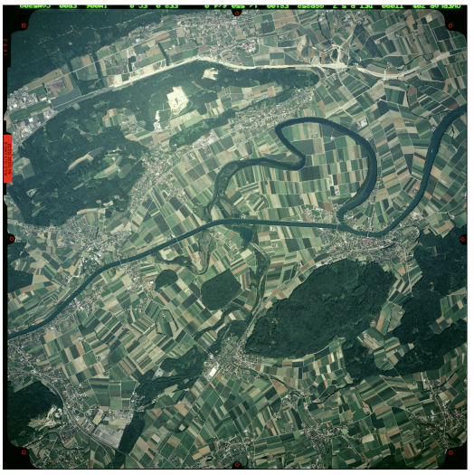
Die Bildsammlung von swisstopo umfasst mehrere hunderttausend analoge Luftbilder (Farb-, Farb-Infrarot- oder SW-Bilder). Diese sind in Form der Bildzentrumskoordinaten, des jeweiligen abgedeckten Bodensegments (Footprint) sowie mit Metainformationen (mit den entsprechenden Orientierungsparametern, falls verfügbar) dargestellt. Bereits digitalisierte Aufnahmen können in voller Auflösung heruntergeladen und angezeigt werden. Fehlende Scans der Bilder werden nach und nach ergänzt und direkt zugänglich gemacht.
La collection photographique de swisstopo comprend plusieurs centaines de milliers de photographies aériennes analogiques (en couleur, en infrarouge ou en noir et blanc). Elles sont représentées sous forme de coordonnées du centre de l’image, des zones qu’elles couvrent (footprint), ainsi que par leurs métadonnées (avec les éléments d’orientation correspondants lorsqu’ils sont disponibles). Les images déjà numérisées peuvent être téléchargées et visualisées en pleine résolution. Les scans manquants des images sont progressivement intégrés et rendus directement disponibles.
La collezione fotografica di swisstopo comprende diverse centinaia di migliaia di foto aeree analogiche (a colori, all’infrarosso o in bianco e nero). Esse sono rappresentate sotto forma di coordinate del centro dell’immagine, delle zone da esse ricoperte (footprint), come pure dai loro metadati (con i relativi elementi d'orientazione se disponibili) e, se già digitalizzate, possono essere scaricate e visualizzate in piena risoluzione. Le scansioni mancanti delle immagini vengono progressivamente integrate e rese direttamente disponibili.
The aerial imagery catalogue of swisstopo includes several hundred thousand analogue aerial photographs (in colour, infrared, or black and white). They are represented by the centre-image coordinates, the image footprint, as well as by their metadata (including orientation elements, if available). If already digitised, the images can be downloaded and viewed in full resolution. Missing scans of the images are gradually being added and made directly available.
La collecziun da fotografias da swisstopo cumpiglia pliras tschientmill fotos aviaticas analogas (en colur, infrarot u alv e nair). Quellas vegnan represchentadas sco coordinatas dal center da la maletg, da las zonas ch’ellas cuvran (footprint), sco er cun lur metadatas (cun ils elements d’orientaziun correspundents sche disponibels). Sche ellas èn gia digitalisadas, pon las maletgs vegnir telechargiadas e visualisadas en resoluziun totala. Las scans ch’anc mancan vegnan successivamain integradas ed alura messas a disposiziun directamain.
Simple
-
Autre titreAltri nomi o acronimiAlternate titleAlternate titleAlternativtitel
-
Luftbilder swisstopo farbig
Images aér. swisstopo couleur
Immagini aer. swisstopo colori
Aerial Images swisstopo color
Fotografias ord l'aria colur
-
Date (Création)Data (Creazione)Date (Creation)Date (Creation)Datum (Erstellung)
- 1961-01-01
-
IdentifiantIdentificatoreIdentifierIdentifierKennung
- ch.swisstopo.lubis-luftbilder_farbe
Propriétaire
Proprietario
Owner
Owner
Eigentümer
-
Catégorie de thèmeCategoria ISOTopic categoryTopic categoryThematik
-
-
A Imagerie, cartes de base et occupation du solA Mappe di base con immagini della copertura terrestreA Imagery base maps earth coverA Imagery base maps earth coverA Oberflächenbeschreibung
-
Étendue
Estensione
Extent
Extent
Ausdehnung
Étendue
Estensione
Extent
Extent
Ausdehnung
-
DescriptionDescrizioneDescriptionDescriptionBeschreibung
-
Switzerland
Schweiz
Suisse
Svizzera
Svizra
))

Étendue
Estensione
Extent
Extent
Ausdehnung
Étendue
Estensione
Extent
Extent
Ausdehnung
-
DescriptionDescrizioneDescriptionDescriptionBeschreibung
-
Liechtenstein
Liechtenstein
Liechtenstein
Liechtenstein
Liechtenstein
))

-
Fréquence de mise à jourFrequenza di aggiornamentoMaintenance and update frequencyMaintenance and update frequencyWartungsintervall
-
InconnueSconosciutoUnknownUnknownUnbekannt
-
Durée de conservationDurata di conservazioneDuration of ConservationDuration of ConservationAufbewahrungsdauer NV in Jahren
- 275
-
Évaluation de la valeur archivistiqueValutazione del valore archivisticoAppraisal of Archival ValueAppraisal of Archival ValueBewertung Archivwürdigkeit
-
AAAAA
-
Raison de la valeur d'archivageMotivo del valore archivisticoReason for Archiving ValueReason for Archiving ValueBegründung Archivwürdigkeit
-
Preuve de la pratique couranteProva della pratica commercialeEvidence of business practiceEvidence of business practiceNachweis der Geschäftspraxis
- geocat.ch
-
-
Planification de la conservation et de l'archivage AAP - Conféderation
Pianificazione della conservazione e dell’archiviazione AAP - Confederazione
Conservation and archiving planning AAP - Confederation
-
opendata.swiss
opendata.swiss
opendata.swiss
opendata.swiss
-
- GEMET - INSPIRE themes, version 1.0
-
-
Ortho-imagerie
Orto immagini
Orthoimagery
-
- geocat.ch
-
-
BGDI Bundesgeodaten-Infrastruktur
IFDG l’Infrastructure Fédérale de données géographiques
IFDG Infrastruttura federale dei dati geografici
FSDI Federal Spatial Data Infrastructure
-
Contraintes sur la ressource
Vincoli sulle risorse
Resource constraints
Resource constraints
Ressourcenbeschränkungen
-
Autres contraintesAltri vincoliOther constraintsOther constraintsAndere Einschränkungen
- Opendata BY: Freie Nutzung. Quellenangabe ist Pflicht.Opendata BY: Utilisation libre. Obligation d’indiquer la source.Opendata BY: Libero utilizzo. Indicazione della fonte obbligatoria.Opendata BY: Open use. Must provide the source.
Ressource associée
Risorsa associata
Associated resource
Associated resource
Verlinkte Ressource
-
Type d'associationTipo di associazioneAssociation TypeAssociation TypeAssoziationstyp
-
Citation de travail plus largeCitazione di un'opera più ampiaReference to a master resource of which this one is a partReference to a master resource of which this one is a partÜbergeordneter Datenbestand
-
Metadata ReferenceRiferimento metadatiMetadata ReferenceMetadata ReferenceMetadatenreferenz
Ressource associée
Risorsa associata
Associated resource
Associated resource
Verlinkte Ressource
-
TitreTitoloTitleTitleTitel
-
Digitale Luftbilder / Flugaufnahmen
Photographies aériennes numériques
Fotografie aeree digitali
Digital aerial photographs
-
Type d'associationTipo di associazioneAssociation TypeAssociation TypeAssoziationstyp
-
Citation de travail plus largeCitazione di un'opera più ampiaReference to a master resource of which this one is a partReference to a master resource of which this one is a partÜbergeordneter Datenbestand
-
LangueLinguaLanguageLanguageSprache
- Deutsch
-
Encodage de caractèresCodifica dei caratteriCharacter encodingCharacter encodingZeichenkodierung
-
Utf8UTF8UTF8UTF8Utf8
-
Catégorie de sous-thèmeCategoria di sottotemaSubtopic CategorySubtopic CategoryThematische Unterkategorien
-
A3 Images aériennes, satellitesA3 Immagini aeree e satellitariA3 Aerial and Satellite ImageryA3 Aerial and Satellite ImageryA3 Luft-, Satellitenbilder
-
Géodonnées de baseGeodati di baseBasic GeodataBasic GeodataGeobasisdaten
- true
-
Identifiant Géodonnées de baseIdentificativo dei geodati di baseBasic Geodata IDBasic Geodata IDIdentifikator des Geobasisdatensatzes
-
36.1
-
Niveau des géodonnées de baseLivello legale dei geodati di baseBasic Geodata Legal LevelBasic Geodata Legal LevelGeobasisdatenebene
-
FédéralFederaleFederalFederalNational
-
Format de distributionFormato (codifica)Distribution formatDistribution formatAbgabeformat
-
-
Cloud Optimized GeoTIFF (TIFF / TIF)
-
Options de transfert numérique
Opzioni di trasferimento digitale
Digital transfer options
Digital transfer options
Optionen für die digitale Übertragung
-
Ressource en ligneRisorsa onlineOnLine resourceOnLine resourceOnline
-
ch.swisstopo.lubis-luftbilder_farbe
WMS-BGDI Dienst, Layer "Luftbilder swisstopo farbig"Service WMS-IFDG, couche "Images aér. swisstopo couleur"Servizio WMS-IFDG, strato "Immagini aer. swisstopo colori"WMS-FSDI service, layer "Aerial Images swisstopo color"WMS-BGDI Dienst, Layer "Luftbilder swisstopo farbig"
Options de transfert numérique
Opzioni di trasferimento digitale
Digital transfer options
Digital transfer options
Optionen für die digitale Übertragung
-
Ressource en ligneRisorsa onlineOnLine resourceOnLine resourceOnline
-
Vorschau map.geo.admin.ch
Vorschau map.geo.admin.chAperçu map.geo.admin.chPrevisione map.geo.admin.chPreview map.geo.admin.ch
Options de transfert numérique
Opzioni di trasferimento digitale
Digital transfer options
Digital transfer options
Optionen für die digitale Übertragung
-
Ressource en ligneRisorsa onlineOnLine resourceOnLine resourceOnline
-
ch.swisstopo.lubis-luftbilder_farbe
WMTS-BGDI Dienst, Layer "Luftbilder swisstopo farbig"Service WMTS-IFDG, couche , Layer "Images aér. swisstopo couleur"Servizio WMTS-IFDG, strato "Immagini aer. swisstopo colori"WMTS-FSDI service, layer "Aerial Images swisstopo color"WMTS-BGDI Dienst, Layer "Luftbilder swisstopo farbig"
Options de transfert numérique
Opzioni di trasferimento digitale
Digital transfer options
Digital transfer options
Optionen für die digitale Übertragung
Options de transfert numérique
Opzioni di trasferimento digitale
Digital transfer options
Digital transfer options
Optionen für die digitale Übertragung
-
Ressource en ligneRisorsa onlineOnLine resourceOnLine resourceOnline
-
Webseite Luftbilder
Options de transfert numérique
Opzioni di trasferimento digitale
Digital transfer options
Digital transfer options
Optionen für die digitale Übertragung
-
Ressource en ligneRisorsa onlineOnLine resourceOnLine resourceOnline
-
Link für Datenbezug
Options de transfert numérique
Opzioni di trasferimento digitale
Digital transfer options
Digital transfer options
Optionen für die digitale Übertragung
-
Ressource en ligneRisorsa onlineOnLine resourceOnLine resourceOnline
-
LUBIS-Viewer
Options de transfert numérique
Opzioni di trasferimento digitale
Digital transfer options
Digital transfer options
Optionen für die digitale Übertragung
-
Ressource en ligneRisorsa onlineOnLine resourceOnLine resourceOnline
-
RESTful API von geo.admin.ch
RESTful API von geo.admin.chRESTful API de geo.admin.chRESTful API da geo.admin.chRESTful API from geo.admin.chRESTful API dad geo.admin.ch
Metadata
-
Identifiant des métadonnéesIdentificativo della schedaMetadata identifierMetadata identifierIdentifikator des Metadatensatzes
- 352c0302-fac6-455b-bd81-092850a7ad4e
-
LangueLinguaLanguageLanguageSprache
- Deutsch
-
Encodage de caractèresCodifica dei caratteriCharacter encodingCharacter encodingZeichenkodierung
-
Utf8UTF8UTF8UTF8Utf8
-
LangueLinguaLanguageLanguageSprache
- Français
-
Encodage de caractèresCodifica dei caratteriCharacter encodingCharacter encodingZeichenkodierung
-
Utf8UTF8UTF8UTF8Utf8
-
LangueLinguaLanguageLanguageSprache
- Italiano
-
Encodage de caractèresCodifica dei caratteriCharacter encodingCharacter encodingZeichenkodierung
-
Utf8UTF8UTF8UTF8Utf8
-
LangueLinguaLanguageLanguageSprache
- English
-
Encodage de caractèresCodifica dei caratteriCharacter encodingCharacter encodingZeichenkodierung
-
Utf8UTF8UTF8UTF8Utf8
-
LangueLinguaLanguageLanguageSprache
- Rumantsch
-
Encodage de caractèresCodifica dei caratteriCharacter encodingCharacter encodingZeichenkodierung
-
Utf8UTF8UTF8UTF8Utf8
Point de contact
Punto di contatto
Point of contact
Point of contact
Ansprechpartner
-
Heures de serviceOrario di servizioHours of serviceHours of serviceBetriebszeiten
-
08h30 - 11h00 / 14h00 - 16h00 GMT+1
Type de ressource
Tipo di risorsa
Type of resource
Type of resource
Anwendungsbereich der Metadaten
-
Domaine d'application de la ressourceAmbito di applicazione della risorsaResource scopeResource scopeDomäne der Ressourcenanwendung
-
Jeu de donnéesSet di datiDatasetDatasetDatenbestand
-
Lien vers la métadonnéeCollegamento ai metadatiMetadata linkageMetadata linkageLink zu den Metadaten
-
Informations de date (Création)Informazioni sulla data (Creazione)Date info (Creation)Date info (Creation)Datumsangaben (Erstellung)
- 2013-12-18T08:53:44Z
-
Informations de date (Révision)Informazioni sulla data (Revisione)Date info (Revision)Date info (Revision)Datumsangaben (Aktualisierung)
- 2026-04-13T09:28:08.487052Z
Norme des métadonnées
Standard dei metadati
Metadata standard
Metadata standard
Metadatenstandard
-
TitreTitoloTitleTitleTitel
-
eCH-0271