geocat.ch
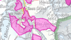
Districts francs fédéraux, cantonaux et mixtes
Périmètres dans lesquels des restrictions de chasse liées à toutes les espèces ou à des espèces en particuliers sont définies au sens de l'Art. 35 LcChP.
Simple
- Alternate title
-
Districts francs
- Date (Creation)
- 2010-01-01
- Date (Revision)
- 2025-07-28
- Identifier
- 51
- Purpose
-
informer le public sur les périmètres des districts francs.
- Status
- Completed
Custodian
- Spatial representation type
- Vector
Spatial resolution
Equivalent scale
- Denominator
- 25000
- Topic category
-
- L Environment
Extent
Extent
- Description
-
Canton of Valais (VS)
))

- Maintenance and update frequency
- userDefined
- Maintenance note
-
tous les 5 ans
Resource format
- Title
-
ESRI Enterprise Geodatabase
- Date
- GEMET - INSPIRE themes, version 1.0
-
-
Habitats and biotopes
-
- GEMET
-
-
hunting
-
wild animal
-
- geocat.ch
-
-
official geodata
-
opendata.swiss
-
Resource constraints
- Use limitation
-
Aucunes
Resource constraints
- Access constraints
- Other restrictions
- Other constraints
-
Géodonnées accessibles au public (niveau A selon l'OGéo)
- Other constraints
-
Les conditions générales d'utilisation des géodonnées du Canton du Valais font foi ( https://www.vs.ch/fr/web/guest/information-legale).
- Language
- Français
- Character encoding
- UTF8
- Environment description
-
S:\Géodonnées VS\L2 Protection de la nature\Districts francs.lyr
- Subtopic Category
- L2 Nature and Landscape Protection
- Basic Geodata
- true
- Basic Geodata ID
-
168>A.1
- Basic Geodata Legal Level
- Cantonal
- Basic Geodata Type
- basicGeodata basicGeodata openGovernmentData
- Distribution format
-
-
ESRI Shapefile (SHP)
-
OGC Web Map Service (WMS)
-
ArcGIS REST Feature Service
-
Distributor
Digital transfer options
- OnLine resource
-
Géoportail du Canton du Valais
Digital transfer options
- OnLine resource
-
OpenData Valais
OpenData Valais - Site de téléchargement de géodonnées à l'Etat du Valais : multiformat et WebMercator
Digital transfer options
- OnLine resource
-
Landing Page
Landing Page pour opendata
Digital transfer options
- OnLine resource
-
Permalink opendata.swiss
Permalink opendata.swiss
Digital transfer options
- OnLine resource
-
12
Districts francs
Digital transfer options
- OnLine resource
-
district_franc
Districts francs fédéraux, cantonaux et mixtes
- Statement
-
Digitalisation sur la base du SwissMapRaster
- Hierarchy level
- Dataset
- Description
-
Digitalisation
Equivalent scale
- Denominator
- 25000
- Geometric object type
- Surface
- Geometric object count
- 267
- Reference system identifier
- EPSG:2056/CH1903+_MN95
Metadata
- Metadata identifier
- 33bfc323-263b-4de6-98d9-e962a0b80247
- Language
- Français
- Character encoding
- UTF8
- Language
- Deutsch
- Character encoding
- UTF8
- Language
- Italiano
- Character encoding
- UTF8
- Language
- English
- Character encoding
- UTF8
- Language
- Rumantsch
- Character encoding
- UTF8
Distributor
Type of resource
- Resource scope
- Dataset
- Metadata linkage
-
https://www.geocat.ch/geonetwork/srv/api/records/33bfc323-263b-4de6-98d9-e962a0b80247
- Date info (Creation)
- 2016-08-26T13:57:53Z
- Date info (Revision)
- 2026-05-29T06:19:04.635429Z
Metadata standard
- Title
-
eCH-0271