geocat.ch
Bahnlärmkataster
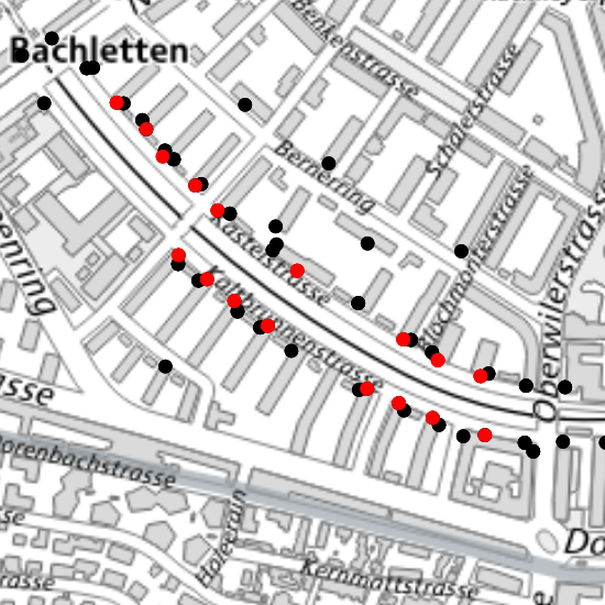
Der Bahnlärmkataster zeigt die berechneten Lärmimmissionen durch den Bahnverkehr. Die Grafik stellt die Grenzwertsituation aufgrund des Emissionsplans 2015 dar. Schwarzes Symbol: keine Grenzwertüberschreitungen; rotes Symbol: Grenzwertüberschreitungen in der Nacht.
Simple
-
Date (Création)Data (Creazione)Date (Creation)Datum (Erstellung)
- 2003-01-02
-
ÉtatStatoStatusBearbeitungsstatus
-
TerminéCompletatoCompletedAbgeschlossen
Propriétaire
Proprietario
Owner
Eigentümer
-
Heures de serviceOrario di servizioHours of serviceBetriebszeiten
-
Mo - Fr: 8.00 - 12.00 und 14.00 - 17.00 Uhr
-
Catégorie de thèmeCategoria ISOTopic categoryThematik
-
-
L EnvironnementL AmbienteL EnvironmentL Umwelt
-
Étendue
Estensione
Extent
Ausdehnung
Étendue
Estensione
Extent
Ausdehnung
-
DescriptionDescrizioneDescriptionBeschreibung
-
Canton of Basel-Stadt (BS)
Kanton Basel-Stadt (BS)
Canton de Bâle-Ville (BS)
Cantone di Basilea Città (BS)
))

-
Fréquence de mise à jourFrequenza di aggiornamentoMaintenance and update frequencyWartungsintervall
-
Comme nécessaireSecondo necessitàAs neededBei Bedarf
- GEMET
-
-
bruit routier
rumore del traffico stradale
road traffic noise
-
- GEMET
-
-
bruit routier
rumore del traffico
traffic noise
-
- GEMET
-
-
polluant sonore
inquinante acustico
noise pollutant
-
- GEMET
-
-
niveau sonore
livello del rumore
noise level
-
- GEMET
-
-
nuisance sonore
disturbo da rumore
noise disturbance
-
- GEMET
-
-
nuisance sonore
disturbo da rumore
noise disturbance
-
- GEMET
-
-
bruit
rumore
noise
-
- geocat.ch
-
-
opendata.swiss
opendata.swiss
opendata.swiss
-
Contraintes sur la ressource
Vincoli sulle risorse
Resource constraints
Ressourcenbeschränkungen
-
Autres contraintesAltri vincoliOther constraintsAndere Einschränkungen
-
Die Geodaten sind öffentlich zugänglich. (Zugangsberechtigungsstufe [A] = öffentlich)
-
Autres contraintesAltri vincoliOther constraintsAndere Einschränkungen
-
Es gelten die Nutzungsbedingungen für Geodaten des Kantons Basel-Stadt. ( http://www.geo.bs.ch/agb)
Ressource associée
Risorsa associata
Associated resource
Verlinkte Ressource
-
Type d'associationTipo di associazioneAssociation TypeAssoziationstyp
-
Description deÈ una descrizione diResource is a description of associated resourceIst Beschreibung von
-
Metadata ReferenceRiferimento metadatiMetadata ReferenceMetadatenreferenz
Ressource associée
Risorsa associata
Associated resource
Verlinkte Ressource
-
TitreTitoloTitleTitel
-
Lärmkataster
-
Type d'associationTipo di associazioneAssociation TypeAssoziationstyp
-
Citation de travail plus largeCitazione di un'opera più ampiaReference to a master resource of which this one is a partÜbergeordneter Datenbestand
-
LangueLinguaLanguageSprache
- Deutsch
-
Encodage de caractèresCodifica dei caratteriCharacter encodingZeichenkodierung
-
Utf8UTF8UTF8Utf8
-
Informations supplémentairesInformazioni supplementariSupplemental InformationZusätzliche Informationen
-
Bezeichnung: Gebäudeadresse, Stockwerk: Höhe des Empfangspunktes, IGW: Immissionsgrenzwert, Tag: 06:00 - 22:00 Uhr, Nacht: 22:00 - 06:00 Uhr, Lr: Beurteilungspegel in Dezibel nach Anhang 4 der Lärmschutz-Verordnung (LSV), 2000: Beurteilung aufgrund der Emission im Jahre 2000, 2015: Beurteilung aufgrund des Emissionsplans für das Jahr 2015, > IGW: Immissionsgrenzwertüberschreitung in Dezibel (dB), Attribute
-
Catégorie de sous-thèmeCategoria di sottotemaSubtopic CategoryThematische Unterkategorien
-
L1 Protection de l’environnement, bruitL1 Protezione ambientale, RumoreL1 Environmental Protection, NoiseL1 Umweltschutz, Lärm
-
Géodonnées de baseGeodati di baseBasic GeodataGeobasisdaten
- true
-
Identifiant Géodonnées de baseIdentificativo dei geodati di baseBasic Geodata IDIdentifikator des Geobasisdatensatzes
-
144
-
Niveau des géodonnées de baseLivello legale dei geodati di baseBasic Geodata Legal LevelGeobasisdatenebene
-
FédéralFederaleFederalNational
-
Type de géodonnées de baseTipo di geodati di baseBasic Geodata TypeGeobasisdatentyp
-
openDataopenDataopenDataopenData
-
Format de distributionFormato (codifica)Distribution formatAbgabeformat
-
-
ESRI Shapefile (SHP)
-
INTERLIS 1 (ITF)
-
Text (TXT)
-
Distributeur
Distributore
Distributor
Verteiler
-
Heures de serviceOrario di servizioHours of serviceBetriebszeiten
-
Mo - Do: 8:00 bis 12:00, 13:30 bis 16:30, Fr: 8:00 bis 12:00, 13:30 bis 16:00
Options de transfert numérique
Opzioni di trasferimento digitale
Digital transfer options
Optionen für die digitale Übertragung
-
Ressource en ligneRisorsa onlineOnLine resourceOnline
-
MapBS
Öffentliches Auskunftssystem des Kantons Basel-Stadt
Options de transfert numérique
Opzioni di trasferimento digitale
Digital transfer options
Optionen für die digitale Übertragung
-
Ressource en ligneRisorsa onlineOnLine resourceOnline
-
Geodaten-Shop
Öffentlich zugänglicher Geodaten-Downloaddienst des Kantons Basel-Stadt
Options de transfert numérique
Opzioni di trasferimento digitale
Digital transfer options
Optionen für die digitale Übertragung
-
Ressource en ligneRisorsa onlineOnLine resourceOnline
-
WMS BS
Die derzeit im WMS BS verfügbaren Datenebenen entsprechen, bis auf wenige Ausnahmen, den Geodaten, welche auch in MapBS dargestellt sind. Der WMS BS ist kostenlos nutzbar und bietet Zugriff auf öffentliche sowie beschränkt öffentliche Geodaten, wobei gegebenenfalls Benutzername und Passwort benötigt werden (Zugangsdaten von MapBS).
Options de transfert numérique
Opzioni di trasferimento digitale
Digital transfer options
Optionen für die digitale Übertragung
-
Ressource en ligneRisorsa onlineOnLine resourceOnline
-
WFS BS
Die derzeit im WFS BS verfügbaren Datenebenen entsprechen, bis auf wenige Ausnahmen, den Geodaten, welche auch in MapBS dargestellt sind. Der WFS BS ist kostenlos nutzbar und bietet Zugriff auf öffentliche sowie beschränkt öffentliche Geodaten, wobei gegebenenfalls Benutzername und Passwort benötigt werden (Zugangsdaten von MapBS).
Options de transfert numérique
Opzioni di trasferimento digitale
Digital transfer options
Optionen für die digitale Übertragung
-
Ressource en ligneRisorsa onlineOnLine resourceOnline
-
Permalink opendata.swiss
Permalink opendata.swissPermalink opendata.swissPermalink opendata.swissPermalink opendata.swiss
-
Nom du système de référenceNome del sistema di riferimentoReference system identifierName des Referenzsystems
- CH1903+ / LV95/EPSG: 2056
Metadata
-
Identifiant des métadonnéesIdentificativo della schedaMetadata identifierIdentifikator des Metadatensatzes
- 2d1ffab9-decf-4d55-8102-d9c9d94f37c5
-
LangueLinguaLanguageSprache
- Deutsch
-
Encodage de caractèresCodifica dei caratteriCharacter encodingZeichenkodierung
-
Utf8UTF8UTF8Utf8
-
LangueLinguaLanguageSprache
- Français
-
Encodage de caractèresCodifica dei caratteriCharacter encodingZeichenkodierung
-
Utf8UTF8UTF8Utf8
-
LangueLinguaLanguageSprache
- Italiano
-
Encodage de caractèresCodifica dei caratteriCharacter encodingZeichenkodierung
-
Utf8UTF8UTF8Utf8
-
LangueLinguaLanguageSprache
- English
-
Encodage de caractèresCodifica dei caratteriCharacter encodingZeichenkodierung
-
Utf8UTF8UTF8Utf8
Dépositaire
Custode
Custodian
Verwalter
Type de ressource
Tipo di risorsa
Type of resource
Anwendungsbereich der Metadaten
-
Domaine d'application de la ressourceAmbito di applicazione della risorsaResource scopeDomäne der Ressourcenanwendung
-
Jeu de donnéesSet di datiDatasetDatenbestand
-
Informations de date (Création)Informazioni sulla data (Creazione)Date info (Creation)Datumsangaben (Erstellung)
- 2011-09-01T11:37:27Z
-
Informations de date (Révision)Informazioni sulla data (Revisione)Date info (Revision)Datumsangaben (Aktualisierung)
- 2026-04-13T09:21:23.606219Z
Norme des métadonnées
Standard dei metadati
Metadata standard
Metadatenstandard
-
TitreTitoloTitleTitel
-
eCH-0271