 geocat.ch
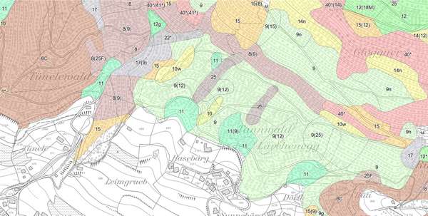
Standortskarte
Die vegetationskundliche Standortskarte des Kantons St.Gallen gibt die natürlichen Waldgesellschaften wieder, die ohne menschliche Eingriffe zu erwarten wären. Die (Oberklassen) NaiS-Typenkarten sind Derivate der Standortskarte. Dabei werden Waldgesellschaften, Übergänge bzw. Mosaike zu grösseren Einheiten zusammengefasst. Sie dienen als Grundlage für die Bewirtschaftung des Schutzwaldes. Das Datenderivat Wertvolle Waldlebensräume zeigt die Waldflächen mit hohem ökologischen Potenzial, die einen besonderen Umgang erfordern.
Simple
- Date (Creation)
- 2014-02-25
- Date (Revision)
- 2026-06-21
- Other citation details
-
Wald, Flora, Fauna
- Purpose
-
Planungsgrundlage
- Status
- On going
partner
- Hours of service
-
Mo. - Fr. von 8:00 - 17:00 Uhr
- Spatial representation type
- Vector
Spatial resolution
Equivalent scale
- Denominator
- 5000
Spatial resolution
- Spatial resolution
- 5 m
- Topic category
-
- G Biota
Extent
Extent
- Description
-
Kanton St.Gallen
))
- Maintenance and update frequency
- As needed
- geocat.ch
-
-
Standortskarte
-
opendata.swiss
-
Resource constraints
- Access constraints
- Other restrictions
- Other constraints
-
A = öffentlich
Resource constraints
- Classification
- Unclassified
- Language
- Deutsch
- Distribution format
-
-
ESRI Shapefile
-
andere Formate auf Anfrage
-
Distributor
- Hours of service
-
Mo. - Fr. von 8:00 - 17:00 Uhr
- Statement
-
von 1990 bis 2008, durch Spezialisten im Auftrag des Kantonsforstamtes
- Hierarchy level
- Dataset
- Reference system identifier
- CH1903+_LV95 / EPSG 2056
Metadata
- Metadata identifier
- 2c3a47ce-5df2-4c8a-a2db-619e65913222-8371
- Language
- Deutsch
- Character encoding
- UTF8
Resource provider
- Hours of service
-
Mo. - Fr. von 8:00 - 17:00 Uhr
Type of resource
- Resource scope
- Dataset
- Date info (Revision)
- 2026-06-21T01:15:40+02:00
Metadata standard
- Title
-
GM03 Core
)))
