geocat.ch
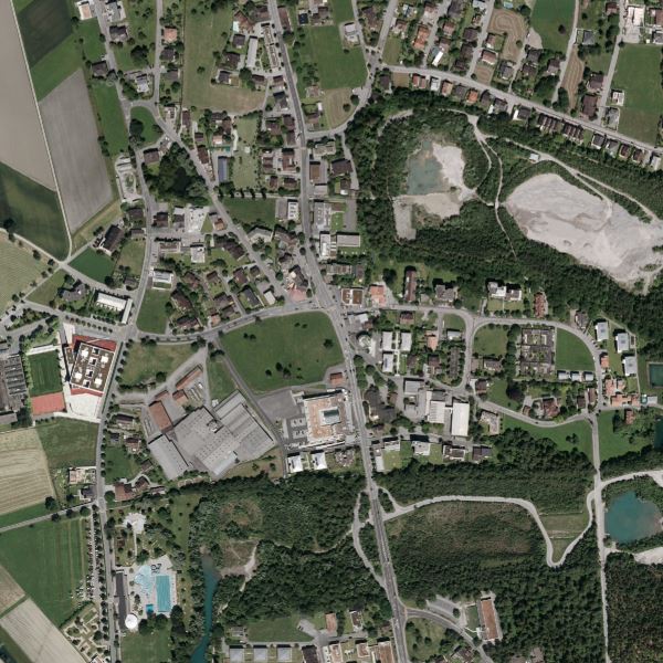
Orthophoto Liechtenstein 2012
Orthophoto with a resolution of 12.5 cm ground pixels. The orthophoto was flown from 16 June to 18 August 2012 with a Vexcel Ultracam XP RGBI digital area scan camera. The flight altitude above ground was approx. 2200m. It is available in true colour (RGB) as well as in infrared (CIR).
Simple
- Date (Creation)
- 2012-08-28
- Identifier
- https://metadata.geo.llv.li/2b02c693-1d51-4e67-b823-7a37eaefd1ee
- Purpose
-
Basic data of the GDI-Liechtenstein
- Status
- Completed
Publisher
- Hours of service
-
8:00-11:30 und 13:30-17:00
- Spatial representation type
- Grid
Spatial resolution
- Spatial resolution
- 0.125 m
- Topic category
-
- A Imagery base maps earth cover
Extent
Extent
- Description
-
Liechtenstein
))

- Maintenance and update frequency
- Not planned
Resource format
- Title
-
GeoTIFF (GEOTIFF)
- Date
- geocat.ch
-
-
orthophoto
-
INSPIRE
-
digital color orthophoto mosaic
-
OpenData
-
- GEMET - INSPIRE themes, version 1.0
-
-
Orthoimagery
-
- Räumlicher Anwendungsbereich
-
-
National
-
Resource constraints
- Use limitation
-
no Conditions apply
- Access constraints
- Other restrictions
- Use constraints
- Other restrictions
- Other constraints
- No limitations to public access
Resource constraints
- Access constraints
- Other restrictions
- Use constraints
- Other restrictions
- Other constraints
- No conditions to access and use
- Other constraints
- Opendata BY: Open use. Must provide the source.
- Language
- Deutsch
- Character encoding
- UTF8
- Environment description
-
Ultracam XP - Digitale Flächenkamera
- Supplemental Information
-
Der Datensatz liegt in einzelnen Kacheln mit einer Grösse von 1.25 km2 vor
- Subtopic Category
- A1 Base Maps, Landscape Models
- Subtopic Category
- A3 Aerial and Satellite Imagery
- Attribute description
- RGB-Farbwert
- Distribution format
-
-
GeoTIFF (GEOTIFF)
-
Point of contact
- Hours of service
-
8:00-11:30 und 13:30-17:00
Digital transfer options
- Units of distribution
-
1 Kachel
- OnLine resource
-
Geodatenportal der Liechtensteinischen Landesverwaltung
Geodata Portal of the National Administration
Digital transfer options
- Units of distribution
-
1 Kachel
- OnLine resource
-
li.abi.orthophoto2012
OGC-WMS Service of the National Administration
Digital transfer options
- Units of distribution
-
1 Kachel
- OnLine resource
-
Download-Link des Geodatenportals
Download as GeoTiff via the geodata portal
- Hierarchy level
- Dataset
Report
Result
- Title
-
VERORDNUNG (EG) Nr. 1089/2010 DER KOMMISSION vom 23. November 2010 zur Durchführung der Richtlinie 2007/2/EG des Europäischen Parlaments und des Rates hinsichtlich der Interoperabilität von Geodatensätzen und -diensten
- Date (Publication)
- 2010-12-08
- Explanation
-
Gemäss INSPIRE Bestandteil des Themas Orthofotografie
- Pass
- false
- Statement
-
Luftbildbefliegung aus einer Flughöhe von ca. 2200m über Grund
- Hierarchy level
- Dataset
- Description
-
digitale Luftbilder
- Number of dimensions
- 2
- Cell geometry
- Area
- Transformation parameter availability
- 1
- Reference system identifier
- http://www.opengis.net/def/crs/EPSG/0/21782
- Reference system identifier
- http://www.opengis.net/def/crs/EPSG/0/4936
- Maintenance and update frequency
- As needed
Metadata
- Metadata identifier
- 2b02c693-1d51-4e67-b823-7a37eaefd1ee
- Language
- Deutsch
- Character encoding
- UTF8
- Language
- Français
- Character encoding
- UTF8
- Language
- Italiano
- Character encoding
- UTF8
- Language
- English
- Character encoding
- UTF8
Point of contact
- Hours of service
-
8:00-11:30 und 13:30-17:00
Type of resource
- Resource scope
- Dataset
- Metadata linkage
-
https://www.geocat.ch/geonetwork/srv/api/records/2b02c693-1d51-4e67-b823-7a37eaefd1ee
- Date info (Creation)
- 2013-08-30T14:42:18Z
- Date info (Revision)
- 2026-04-13T09:09:48.753515Z
Metadata standard
- Title
-
eCH-0271