geocat.ch
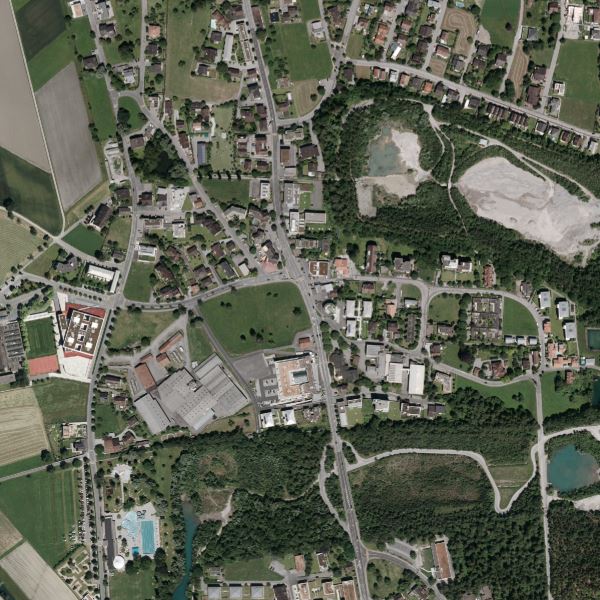
Orthophoto Liechtenstein 2012
Orthophoto Liechtenstein 2012
Orthophoto mit einer Auflösung von 12.5 cm Bodenpixel. Das Orthophoto wurde vom 16. Juni bis 18. August 2012 mit einer Vexcel Ultracam XP RGBI - Digitale Flächenkamera geflogen. Die Flughöhe über Grund betrug ca. 2200m. Es liegt in Echtfarben (RGB) als auch in Infrarot (CIR) vor.
Orthophoto with a resolution of 12.5 cm ground pixels. The orthophoto was flown from 16 June to 18 August 2012 with a Vexcel Ultracam XP RGBI digital area scan camera. The flight altitude above ground was approx. 2200m. It is available in true colour (RGB) as well as in infrared (CIR).
Simple
-
Date (Création)Data (Creazione)Date (Creation)Datum (Erstellung)
- 2012-08-28
-
IdentifiantIdentificatoreIdentifierKennung
- https://metadata.geo.llv.li/2b02c693-1d51-4e67-b823-7a37eaefd1ee
-
ButScopoPurposeZweck
-
Grundlagedaten der GDI-Liechtenstein
Basic data of the GDI-Liechtenstein
-
ÉtatStatoStatusBearbeitungsstatus
-
TerminéCompletatoCompletedAbgeschlossen
responsable de la publication
Editore
Publisher
Herausgeber
-
Heures de serviceOrario di servizioHours of serviceBetriebszeiten
-
8:00-11:30 und 13:30-17:00
-
Type de représentation spatialeTipo di rappresentazione spazialeSpatial representation typeRäumliche Darstellungsart
-
grilleRasterGridRaster, Gitter
Résolution spatiale
Risoluzione spaziale
Spatial resolution
Räumliche Auflösung
-
Distance de résolutionDistanza di risoluzioneSpatial resolutionDistanz
- 0.125 m
-
Catégorie de thèmeCategoria ISOTopic categoryThematik
-
-
A Imagerie, cartes de base et occupation du solA Mappe di base con immagini della copertura terrestreA Imagery base maps earth coverA Oberflächenbeschreibung
-
Étendue
Estensione
Extent
Ausdehnung
Étendue
Estensione
Extent
Ausdehnung
-
DescriptionDescrizioneDescriptionBeschreibung
-
Liechtenstein
Liechtenstein
Liechtenstein
Liechtenstein
))

-
Fréquence de mise à jourFrequenza di aggiornamentoMaintenance and update frequencyWartungsintervall
-
Non planifiéeNon pianificatoNot plannedNicht geplant
Format de la ressource
Formato della risorsa
Resource format
Format der Ressource
-
TitreTitoloTitleTitel
-
GeoTIFF (GEOTIFF)
-
DateDataDateDatum
- geocat.ch
-
-
orthophoto
ortofoto
orthophoto
-
INSPIRE
INSPIRE
INSPIRE
-
mosaïque d'orthophotos numériques en couleur
mosaico di ortofoto digitali a colori
digital color orthophoto mosaic
-
OpenData
OpenData
OpenData
-
- GEMET - INSPIRE themes, version 1.0
-
-
Ortho-imagerie
Orto immagini
Orthoimagery
-
- Räumlicher Anwendungsbereich
-
-
Nationales
Nazionali
National
-
Contraintes sur la ressource
Vincoli sulle risorse
Resource constraints
Ressourcenbeschränkungen
-
Limitation d'utilisationLimitazione d'usoUse limitationNutzungsbeschränkung
-
no Conditions apply
-
Contraintes d'accèsVincoli di accessoAccess constraintsZugriffsbeschränkungen
-
Autres restrictionsAltre restrizioniOther restrictionsAndere Beschränkungen
-
Contraintes d'utilisationVincoli d'usoUse constraintsNutzungseinschränkungen
-
Autres restrictionsAltre restrizioniOther restrictionsAndere Beschränkungen
-
Autres contraintesAltri vincoliOther constraintsAndere Einschränkungen
- No limitations to public accessNo limitations to public accessNo limitations to public accessNo limitations to public access
Contraintes sur la ressource
Vincoli sulle risorse
Resource constraints
Ressourcenbeschränkungen
-
Contraintes d'accèsVincoli di accessoAccess constraintsZugriffsbeschränkungen
-
Autres restrictionsAltre restrizioniOther restrictionsAndere Beschränkungen
-
Contraintes d'utilisationVincoli d'usoUse constraintsNutzungseinschränkungen
-
Autres restrictionsAltre restrizioniOther restrictionsAndere Beschränkungen
-
Autres contraintesAltri vincoliOther constraintsAndere Einschränkungen
- No conditions to access and useNo conditions to access and useNo conditions to access and useNo conditions to access and use
-
Autres contraintesAltri vincoliOther constraintsAndere Einschränkungen
- Opendata BY: Freie Nutzung. Quellenangabe ist Pflicht.Opendata BY: Utilisation libre. Obligation d’indiquer la source.Opendata BY: Libero utilizzo. Indicazione della fonte obbligatoria.Opendata BY: Open use. Must provide the source.
-
LangueLinguaLanguageSprache
- Deutsch
-
Encodage de caractèresCodifica dei caratteriCharacter encodingZeichenkodierung
-
Utf8UTF8UTF8Utf8
-
Description de l'environnement de travailDescrizione dell'ambiente di lavoroEnvironment descriptionBeschreibung der Arbeitsumgebung
-
Ultracam XP - Digitale Flächenkamera
-
Informations supplémentairesInformazioni supplementariSupplemental InformationZusätzliche Informationen
-
Der Datensatz liegt in einzelnen Kacheln mit einer Grösse von 1.25 km2 vor
-
Catégorie de sous-thèmeCategoria di sottotemaSubtopic CategoryThematische Unterkategorien
-
A1 Cartes de base, modèles de paysageA1 Mappe di base, modelli paesaggisticiA1 Base Maps, Landscape ModelsA1 Basiskarten, Landschaftsmodelle
-
Catégorie de sous-thèmeCategoria di sottotemaSubtopic CategoryThematische Unterkategorien
-
A3 Images aériennes, satellitesA3 Immagini aeree e satellitariA3 Aerial and Satellite ImageryA3 Luft-, Satellitenbilder
-
Description de l'attributDescrizione dell'attributoAttribute descriptionBeschreibung des Attributs
- RGB-Farbwert
-
Format de distributionFormato (codifica)Distribution formatAbgabeformat
-
-
GeoTIFF (GEOTIFF)
-
Point de contact
Punto di contatto
Point of contact
Ansprechpartner
-
Heures de serviceOrario di servizioHours of serviceBetriebszeiten
-
8:00-11:30 und 13:30-17:00
Options de transfert numérique
Opzioni di trasferimento digitale
Digital transfer options
Optionen für die digitale Übertragung
-
Unités de distributionUnità di distribuzioneUnits of distributionVerteilungseinheiten
-
1 Kachel
-
Ressource en ligneRisorsa onlineOnLine resourceOnline
-
Geodatenportal der Liechtensteinischen Landesverwaltung
Geodatenportal der Liechtensteinischen LandesverwaltungGeodata Portal of the National Administration
Options de transfert numérique
Opzioni di trasferimento digitale
Digital transfer options
Optionen für die digitale Übertragung
-
Unités de distributionUnità di distribuzioneUnits of distributionVerteilungseinheiten
-
1 Kachel
-
Ressource en ligneRisorsa onlineOnLine resourceOnline
-
li.abi.orthophoto2012
OGC WMS Service der Liechtensteinen LandesverwaltungOGC-WMS Service of the National Administration
Options de transfert numérique
Opzioni di trasferimento digitale
Digital transfer options
Optionen für die digitale Übertragung
-
Unités de distributionUnità di distribuzioneUnits of distributionVerteilungseinheiten
-
1 Kachel
-
Ressource en ligneRisorsa onlineOnLine resourceOnline
-
Download-Link des Geodatenportals
Download als GeoTiff über das GeodatenportalsDownload as GeoTiff via the geodata portal
-
NiveauLivelloHierarchy levelBezugsebene
-
Jeu de donnéesSet di datiDatasetDatenbestand
Rapport sur la qualité
Rapporto sulla qualità
Report
Qualitätsbericht
Result
Risultato
Result
Ergebnis
-
TitreTitoloTitleTitel
-
VERORDNUNG (EG) Nr. 1089/2010 DER KOMMISSION vom 23. November 2010 zur Durchführung der Richtlinie 2007/2/EG des Europäischen Parlaments und des Rates hinsichtlich der Interoperabilität von Geodatensätzen und -diensten
-
Date (Publication)Data (Pubblicazione)Date (Publication)Datum (Publikation)
- 2010-12-08
-
ExplicationSpiegazioneExplanationErläuterung
-
Gemäss INSPIRE Bestandteil des Themas Orthofotografie
-
Degré de conformitéGrado di conformitàPassKonformitätsgrad
- false
-
Généralités sur la provenanceInformazioni generali sulla provenienzaStatementErklärung
-
Luftbildbefliegung aus einer Flughöhe von ca. 2200m über Grund
-
NiveauLivelloHierarchy levelBezugsebene
-
Jeu de donnéesSet di datiDatasetDatenbestand
-
DescriptionDescrizioneDescriptionBeschreibung
-
digitale Luftbilder
-
Nombre de dimensionsNumero di dimensioniNumber of dimensionsAnzahl der Dimensionen
- 2
-
Géométrie de la celluleGeometria della cellaCell geometryZellgeometrie
-
SurfaceAreaAreaFläche
-
Disponibilité des paramètres de transformationDisponibilità dei parametri di trasformazioneTransformation parameter availabilityVerfügbarkeit der Transformationsparameter
- 1
-
Nom du système de référenceNome del sistema di riferimentoReference system identifierName des Referenzsystems
- http://www.opengis.net/def/crs/EPSG/0/21782
-
Nom du système de référenceNome del sistema di riferimentoReference system identifierName des Referenzsystems
- http://www.opengis.net/def/crs/EPSG/0/4936
-
Fréquence de mise à jourFrequenza di aggiornamentoMaintenance and update frequencyWartungsintervall
-
Comme nécessaireSecondo necessitàAs neededBei Bedarf
Metadata
-
Identifiant des métadonnéesIdentificativo della schedaMetadata identifierIdentifikator des Metadatensatzes
- 2b02c693-1d51-4e67-b823-7a37eaefd1ee
-
LangueLinguaLanguageSprache
- Deutsch
-
Encodage de caractèresCodifica dei caratteriCharacter encodingZeichenkodierung
-
Utf8UTF8UTF8Utf8
-
LangueLinguaLanguageSprache
- Français
-
Encodage de caractèresCodifica dei caratteriCharacter encodingZeichenkodierung
-
Utf8UTF8UTF8Utf8
-
LangueLinguaLanguageSprache
- Italiano
-
Encodage de caractèresCodifica dei caratteriCharacter encodingZeichenkodierung
-
Utf8UTF8UTF8Utf8
-
LangueLinguaLanguageSprache
- English
-
Encodage de caractèresCodifica dei caratteriCharacter encodingZeichenkodierung
-
Utf8UTF8UTF8Utf8
Point de contact
Punto di contatto
Point of contact
Ansprechpartner
-
Heures de serviceOrario di servizioHours of serviceBetriebszeiten
-
8:00-11:30 und 13:30-17:00
Type de ressource
Tipo di risorsa
Type of resource
Anwendungsbereich der Metadaten
-
Domaine d'application de la ressourceAmbito di applicazione della risorsaResource scopeDomäne der Ressourcenanwendung
-
Jeu de donnéesSet di datiDatasetDatenbestand
-
Informations de date (Création)Informazioni sulla data (Creazione)Date info (Creation)Datumsangaben (Erstellung)
- 2013-08-30T14:42:18Z
-
Informations de date (Révision)Informazioni sulla data (Revisione)Date info (Revision)Datumsangaben (Aktualisierung)
- 2026-04-13T09:09:48.753515Z
Norme des métadonnées
Standard dei metadati
Metadata standard
Metadatenstandard
-
TitreTitoloTitleTitel
-
eCH-0271