 geocat.ch
Atlas des chaînons manquants transfrontaliers dans les infrastructures cyclables du Rhin Supérieur - 2023
Atlas der grenzüberschreitenden Netzlücken der Fahrradinfrastruktur am Oberrhein - 2023
Atlas of cross-border missing links in the Upper Rhine cycling infrastructure - 2023
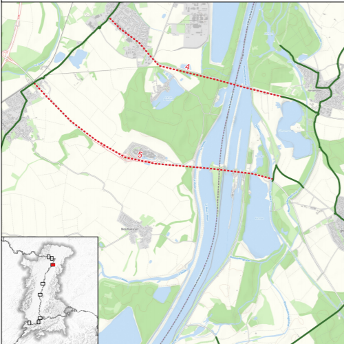
L'atlas cartographique des chaînons manquants cyclables transfrontaliers a été réalisé dans le cadre d'une étude commanditée par le groupe de travail Transports de la Conférence du Rhin Supérieur. L'objectif était d'établir un premier diagnostic sur les ruptures potentielles d'infrastructures cyclables au niveau des frontières qui peuvent représenter un frein à la mobilité cyclable entre les pays. L'approche est basée sur une vue globale du réseau cyclable supra-local dans le
Rhin supérieur, les données utilisées ne sont donc pas exhaustives sur l'ensemble du territoire. L’utilité de raccorder les chaînons manquants respectifs doit être vérifiée au cas par cas (p. ex. sur la base d’une évaluation du potentiel d’utilisateurs).
Der kartografische Atlas der grenzüberschreitenden fehlenden Lücken im Radverkehr wurde im Rahmen einer Studie erstellt, die von der Arbeitsgruppe Verkehr der Oberrheinkonferenz in Auftrag gegeben wurde. Ziel war es, eine erste Diagnose über die potenziellen Lücken in der Fahrradinfrastruktur an den Grenzen, die ein Hindernis für die Fahrradmobilität zwischen den Ländern darstellen können zu erstellen. Der Ansatz basiert auf einer Gesamtansicht des überörtlichen Radwegenetzes im Oberrhein. Die verwendeten Daten sind also nicht erschöpfend für das gesamte Oberrheingebiet. Der Nutzen der Schließung der jeweiligen fehlenden Lücken muss im Einzelfall überprüft werden (z.B. auf der Grundlage einer Bewertung des Nutzerpotenzials).
The map atlas of cross-border missing links for cycling was produced as part of a study commissioned by the Upper Rhine Conference Transport Working Group. The objective was to make an initial diagnosis of potential gaps in cycling infrastructure at the borders that can be an obstacle to cycle mobility between countries. The approach is based on an overview of the supra-local cycle network in the Upper Rhine. The data used are not exhaustive for the whole area. The usefulness of filling in the respective missing links has to be verified on a case-by-case basis (e.g. on the basis of an assessment of the user potential).
Simple
-
Datum (Erstellung)Date (Creation)Date (Création)
- 2023-03-29
-
Datum (Publikation)Date (Publication)Date (Publication)
- 2023-04-05
-
KennungIdentifierIdentifiant
- 19_2022_310
-
BearbeitungsstatusStatusÉtat
-
AbgeschlossenCompletedTerminé
Kontakt für die Ressource
Point of contact
Contact pour la ressource
-
mri:deliveryPointmri:deliveryPointmri:deliveryPoint
-
100, avenue d'Alsace
100, avenue d'Alsace
-
mri:citymri:citymri:city
-
COLMAR
-
mri:postalCodemri:postalCodemri:postalCode
-
68000
-
mri:countryCountrymri:country
-
FRANCE
FRANCE
-
mri:electronicMailAddressmri:electronicMailAddressmri:electronicMailAddress
-
GeoRhena
Räumliche Auflösung
Spatial resolution
Résolution spatiale
Vergleichsmassstab
Equivalent scale
Fraction représentative
-
MassstabszahlDenominatorDénominateur
- 10000
-
ThematikTopic categoryCatégorie de thème
-
-
P VerkehrswesenP TransportationP Transport
-
Ausdehnung
Extent
Étendue
Ausdehnung
Extent
Étendue
Zeitlicher Umfang
Temporal extent
Étendue temporelle
-
ZeitraumTime periodPériode
- 2022-01-01 2022-12-31
Ausdehnung
Extent
Étendue
Ausdehnung
Extent
Étendue
))
-
WartungsintervallMaintenance and update frequencyFréquence de mise à jour
-
Nicht geplantNot plannedNon planifiée
- Keywords
-
-
Carte
Karte
Map
-
-
OrtPlacePosition
-
-
Rhin Supérieur
Oberrhein
Upper Rhine
-
- GEMET - Concepts, version 2.4
-
-
transport
Transport
transportation
-
piste cyclable
Radweg
cycle path
-
Ressourcenbeschränkungen
Resource constraints
Contraintes sur la ressource
-
NutzungsbeschränkungUse limitationLimitation d'utilisation
-
Licence CC BY
Licence CC BY
Licence CC BY
Ressourcenbeschränkungen
Resource constraints
Contraintes sur la ressource
-
ZugriffsbeschränkungenAccess constraintsContraintes d'accès
-
Andere BeschränkungenOther restrictionsAutres restrictions
-
NutzungseinschränkungenUse constraintsContraintes d'utilisation
-
Andere BeschränkungenOther restrictionsAutres restrictions
-
Andere EinschränkungenOther constraintsAutres contraintes
-
Pas d'autre limitation
Keine andere Einschränkung
No other limitation
-
SpracheLanguageLangue
- Français
-
ZeichenkodierungCharacter encodingEncodage de caractères
-
Utf8UTF8Utf8
-
SpracheLanguageLangue
- Deutsch
-
ZeichenkodierungCharacter encodingEncodage de caractères
-
Utf8UTF8Utf8
-
AbgabeformatDistribution formatFormat de distribution
-
-
Carte au format PDF
Karte in PDF
PDF Map
-
Optionen für die digitale Übertragung
Digital transfer options
Options de transfert numérique
-
OnlineOnLine resourceRessource en ligne
-
Téléchargement du Pdf
Pdf herunterladen
Pdf Download
-
ErklärungStatementGénéralités sur la provenance
-
Les données ont été collectées auprès des différents gestionnaires de l'information sur le territoire (Collectivité européenne d'Alsace, Cantons suisses, Länder du Bade-Wurtemberg et de Rhénanie-Palatinat ainsi que Landkreise). Ces données ont ensuite été traitées par un algorithme permettant d'identifier des premiers potentiels chaînons manquants. Au final les experts de la thématique cyclable ont validé ou invalidé ce premier résultat obtenu de manière automatique.
Die Daten wurden von den verschiedenen Informationsmanagern des Gebiets gesammelt (Collectivité Européenne d'Alsace, Schweizer Kantone, die Länder Baden-Württemberg und Rheinland-Pfalz sowie die Landkreise) erhoben. Anschließend wurden diese Daten mit einem Algorithmus verarbeitet, der es ermöglichte, erste potenzielle Missing Links zu identifizieren. Am Ende haben die Experten für das Thema Radfahren dieses erste, automatisch ermittelte Ergebnis bestätigt oder für ungültig erklärt.
The data was collected from the various information managers in the area (Collectivité européenne d'Alsace, Swiss Cantons, Länder of Baden-Württemberg and Rhineland-Palatinate and Landkreise). These data were then processed by an algorithm to identify potential first missing links. In the end, the experts in the field of cycling validated or invalidated this first automatic result.
Metadata
-
Identifikator des MetadatensatzesMetadata identifierIdentifiant des métadonnées
- 2ac1a0e2-d642-4bb7-bf38-77dd97748e14
-
SpracheLanguageLangue
- Français
-
ZeichenkodierungCharacter encodingEncodage de caractères
-
Utf8UTF8Utf8
-
SpracheLanguageLangue
- Deutsch
-
ZeichenkodierungCharacter encodingEncodage de caractères
-
Utf8UTF8Utf8
-
SpracheLanguageLangue
- English
-
ZeichenkodierungCharacter encodingEncodage de caractères
-
Utf8UTF8Utf8
Kontaktstelle für Metadaten
Contact
Point de contact des métadonnées
Anwendungsbereich der Metadaten
Type of resource
Type de ressource
-
Domäne der RessourcenanwendungResource scopeDomaine d'application de la ressource
-
staticMapstaticMapstaticMap
-
NameNameNom
-
Dataset
-
Datumsangaben (Aktualisierung)Date info (Revision)Informations de date (Révision)
- 2023-04-05T12:21:13.773098Z
Metadatenstandard
Metadata standard
Norme des métadonnées
-
TitelTitleTitre
-
ISO 19115-3:2018
-
AusgabeEditionÉdition
-
1.0
Overviews
Spatial extent
)))