geocat.ch
Geologischer Atlas der Schweiz 1:25000
Atlas géologique de la Suisse au 1:25000
Atlante geologico della Svizzera 1:25000
Geological Atlas of Switzerland 1:25000
Atlas geologic da la Svizra 1:25000
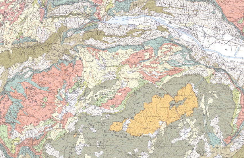
Die Blätter des Geologischen Atlas der Schweiz (GA25) geben detailliert Auskunft über die obersten Schichten des Untergrundes. Die geologischen Formationen werden mittels Farben, Signaturen und Symbolen nach ihrem Alter, ihrer stofflichen Beschaffenheit und ihrer Lagerung (Tektonik) dargestellt. Zu jedem Kartenblatt wird ein Erläuterungsheft publiziert, in welchem die Formationen sowie die geologischen Besonderheiten des betreffenden Gebietes beschrieben sind. Von den ca. 220 geplanten Kartenblättern sind etwas mehr als zwei Drittel bereits erschienen.
Les feuilles de l'Atlas géologique de la Suisse (GA25) fournissent des renseignements détaillés sur les couches superficielles du sous-sol. Les formations géologiques sont représentées au moyen de couleurs, et de figurés en fonction de leur âge, de la nature de leurs substances et de leurs relations stratigraphiques (tectonique). Chaque feuille de l'atlas est publiée avec une notice explicative décrivant les formations et les particularités géologiques du secteur concernée. Des 220 cartes géologiques prévues, deux gros tiers sont déjà publiés.
I fogli dell'Atlante geologico della Svizzera (GA25) forniscono informazioni dettagliate sugli strati superiori del sottosuolo. Le formazioni geologiche vengono rappresentate a colori e corredate da simboli e sigle in funzione della loro età, della natura della loro composizione e della loro stratificazione (tettonica). Per ogni foglio della carta viene pubblicato un quaderno esplicativo in cui sono descritte le formazioni e le particolarità geologiche della rispettiva zona. Dei circa 220 fogli della carta ne è già stata pubblicata due terzi.
The sheets of the Geological Atlas of Switzerland (GA25) give detailed information about the uppermost layers of the subsurface structure. Geological formations are represented by colours, conventional signs and symbols, which correspond to their age, composition and tectonic structure. For each sheet, an explanatory booklet is also published, in which the geological formations and special features of the study area are described. Over two thirds of the 220 map sheets that are planned have already been published.
Ils fegls da l'Atlas geologic da la Svizra (GA25) infurmeschan detagliadamain davart las stresas superiuras dal sutterren. Las furmaziuns geologicas vegnan preschentadas cun agid da colurs, signaturas e simbols tenor lur vegliadetgna, lur cumposiziun materiala e lur giaschament (tectonica). Tar mintga fegl vegn publitgà in carnet cun explicaziuns che descrivan las furmaziuns sco er las particularitads geologicas dal territori pertutgà. Dals ca. 220 fegls previs èn gia cumparids bundant 2/3.
Simple
-
Autre titreAltri nomi o acronimiAlternate titleAlternate titleAlternativtitel
-
Geologischer Atlas GA25
Atlas géologique GA25
Atlante geologico GA25
Geological Atlas GA25
Atlas geologic GA25
-
Date (Dernière révision)Data (Ultima revisione)Date (Last Revision)Date (Last Revision)Datum (Letzte Überprüfung)
- 2022-04-01
-
Date (Création)Data (Creazione)Date (Creation)Date (Creation)Datum (Erstellung)
- 1930-01-01T00:00:00
-
IdentifiantIdentificatoreIdentifierIdentifierKennung
- ch.swisstopo.geologie-geologischer_atlas
-
Forme de la présentationForma della presentazionePresentation formPresentation formPräsentationsform
-
Carte papierMappa cartaceaHardcopy mapHardcopy mapPapierkarte
-
Forme de la présentationForma della presentazionePresentation formPresentation formPräsentationsform
-
Carte numériqueMappa digitaleDigital mapDigital mapDigitale Karte
-
ButScopoPurposePurposeZweck
-
Detailliert Auskunft über den obersten Bereich des Untergrundes der Schweiz
Renseignements détaillés sur les couches supérieures du sous-sol de la Suisse
-
ÉtatStatoStatusStatusBearbeitungsstatus
-
En développementIn fase di sviluppoUnder developmentUnder developmentIn Entwicklung
Distributeur
Distributore
Distributor
Distributor
Verteiler
Point de contact
Punto di contatto
Point of contact
Point of contact
Ansprechpartner
Propriétaire
Proprietario
Owner
Owner
Eigentümer
-
Type de représentation spatialeTipo di rappresentazione spazialeSpatial representation typeSpatial representation typeRäumliche Darstellungsart
-
grilleRasterGridGridRaster, Gitter
-
Type de représentation spatialeTipo di rappresentazione spazialeSpatial representation typeSpatial representation typeRäumliche Darstellungsart
-
paperMappaperMappaperMappaperMappaperMap
Résolution spatiale
Risoluzione spaziale
Spatial resolution
Spatial resolution
Räumliche Auflösung
Fraction représentative
Frazione rappresentativa
Equivalent scale
Equivalent scale
Vergleichsmassstab
-
DénominateurDenominatoreDenominatorDenominatorMassstabszahl
- 25000
-
Catégorie de thèmeCategoria ISOTopic categoryTopic categoryThematik
-
-
F Informations géoscientifiquesF Informazioni geoscientificheF Geoscientific informationF Geoscientific informationF Erdwissenschaften
-
Étendue
Estensione
Extent
Extent
Ausdehnung
Étendue
Estensione
Extent
Extent
Ausdehnung
-
DescriptionDescrizioneDescriptionDescriptionBeschreibung
-
National Map 1:25'000
Landeskarte 1:25'000
Carte nationale 1:25'000
Carta nazionale 1:25'000
-
Identifiant géographiqueIdentificatore geograficoGeographic identifierGeographic identifierGeografische Kennung
- NM25LK25CN25CN25CN25
))

-
Fréquence de mise à jourFrequenza di aggiornamentoMaintenance and update frequencyMaintenance and update frequencyWartungsintervall
-
IrrégulièreIrregolareIrregularIrregularUnregelmässig
-
Durée de conservationDurata di conservazioneDuration of ConservationDuration of ConservationAufbewahrungsdauer NV in Jahren
- 275
-
Évaluation de la valeur archivistiqueValutazione del valore archivisticoAppraisal of Archival ValueAppraisal of Archival ValueBewertung Archivwürdigkeit
-
AAAAA
-
Raison de la valeur d'archivageMotivo del valore archivisticoReason for Archiving ValueReason for Archiving ValueBegründung Archivwürdigkeit
-
Preuve de la pratique couranteProva della pratica commercialeEvidence of business practiceEvidence of business practiceNachweis der Geschäftspraxis
- geocat.ch
-
-
carte géologique
carta geologica
geologic map
-
e-geo.ch
e-geo.ch
e-geo.ch
-
géodonnées de base
geodati di base
official geodata
-
Planification de la conservation et de l'archivage AAP - Conféderation
Pianificazione della conservazione e dell’archiviazione AAP - Confederazione
Conservation and archiving planning AAP - Confederation
-
opendata.swiss
opendata.swiss
opendata.swiss
opendata.swiss
-
- GEMET - INSPIRE themes, version 1.0
-
-
Géologie
Geologia
Geology
-
- GEMET
-
-
pierre
pietra (edilizia)
stone
-
sédimentation
sedimentazione (geologia)
sedimentation (geology)
-
géomorphologie
geomorfologia
geomorphology
-
processus géologique
processi geologici
geological process
-
tectonique
tettonica
tectonics
-
sciences de la terre
scienze della terra
earth science
-
- geocat.ch
-
-
IFDG l’Infrastructure Fédérale de données géographiques
IFDG Infrastruttura federale dei dati geografici
FSDI Federal Spatial Data Infrastructure
-
Contraintes sur la ressource
Vincoli sulle risorse
Resource constraints
Resource constraints
Ressourcenbeschränkungen
-
Autres contraintesAltri vincoliOther constraintsOther constraintsAndere Einschränkungen
- Opendata BY: Freie Nutzung. Quellenangabe ist Pflicht.Opendata BY: Utilisation libre. Obligation d’indiquer la source.Opendata BY: Libero utilizzo. Indicazione della fonte obbligatoria.Opendata BY: Open use. Must provide the source.
Ressource associée
Risorsa associata
Associated resource
Associated resource
Verlinkte Ressource
-
TitreTitoloTitleTitleTitel
-
Geologisches Kartenwerk
Cartes géologiques
Carte geologiche
-
Type d'associationTipo di associazioneAssociation TypeAssociation TypeAssoziationstyp
-
Citation de travail plus largeCitazione di un'opera più ampiaReference to a master resource of which this one is a partReference to a master resource of which this one is a partÜbergeordneter Datenbestand
-
LangueLinguaLanguageLanguageSprache
- Deutsch
-
Encodage de caractèresCodifica dei caratteriCharacter encodingCharacter encodingZeichenkodierung
-
Utf8UTF8UTF8UTF8Utf8
-
LangueLinguaLanguageLanguageSprache
- Français
-
Encodage de caractèresCodifica dei caratteriCharacter encodingCharacter encodingZeichenkodierung
-
Utf8UTF8UTF8UTF8Utf8
-
Informations supplémentairesInformazioni supplementariSupplemental InformationSupplemental InformationZusätzliche Informationen
-
Einige Karten sind vergriffen, einige Karten im Vektorformat erhältlich.
Quelques cartes sont épuisé, quelques cartes sont disponible en version jeux de données vectorielles.
-
Catégorie de sous-thèmeCategoria di sottotemaSubtopic CategorySubtopic CategoryThematische Unterkategorien
-
F1 GéologieF1 GeologiaF1 GeologyF1 GeologyF1 Geologie
-
Géodonnées de baseGeodati di baseBasic GeodataBasic GeodataGeobasisdaten
- true
-
Identifiant Géodonnées de baseIdentificativo dei geodati di baseBasic Geodata IDBasic Geodata IDIdentifikator des Geobasisdatensatzes
-
46.1
-
Niveau des géodonnées de baseLivello legale dei geodati di baseBasic Geodata Legal LevelBasic Geodata Legal LevelGeobasisdatenebene
-
FédéralFederaleFederalFederalNational
-
Niveau de responsabilité des géodonnées de baseLivello di responsabilità dei geodati di baseBasic Geodata Responsibility LevelBasic Geodata Responsibility LevelInformationen über die Zuständigkeitsebene der Geobasisdaten
-
FédéralFederaleFederalFederalNational
-
Niveau d'accès des géodonnées de baseLivello di accesso ai geodati di baseBasic Geodata Access LevelBasic Geodata Access LevelInformationen über die Zugangsberechtigungsstufe zu Geobasisdaten
-
AAAAA
-
Format de distributionFormato (codifica)Distribution formatDistribution formatAbgabeformat
-
-
analog
-
GeoTIFF (GEOTIFF)
-
Options de transfert numérique
Opzioni di trasferimento digitale
Digital transfer options
Digital transfer options
Optionen für die digitale Übertragung
-
Ressource en ligneRisorsa onlineOnLine resourceOnLine resourceOnline
-
Vorschau map.geo.admin.ch
Vorschau map.geo.admin.chAperçu map.geo.admin.chPrevisione map.geo.admin.chPreview map.geo.admin.ch
Options de transfert numérique
Opzioni di trasferimento digitale
Digital transfer options
Digital transfer options
Optionen für die digitale Übertragung
-
Ressource en ligneRisorsa onlineOnLine resourceOnLine resourceOnline
-
ch.swisstopo.geologie-geologischer_atlas
WMS-BGDI Dienst, Layer "Geologischer Atlas GA25"Service WMS-IFDG, couche "Atlas géologique GA25"Servizio WMS-IFDG, strato "Atlante geologico GA25"WMS-FSDI service, layer "Geological Atlas GA25"WMS-BGDI Dienst, Layer "Geologischer Atlas GA25"
Options de transfert numérique
Opzioni di trasferimento digitale
Digital transfer options
Digital transfer options
Optionen für die digitale Übertragung
-
Ressource en ligneRisorsa onlineOnLine resourceOnLine resourceOnline
-
ch.swisstopo.geologie-geologischer_atlas
WMTS-BGDI Dienst, Layer "Geologischer Atlas GA25"Service WMTS-IFDG, couche , Layer "Atlas géologique GA25"Servizio WMTS-IFDG, strato "Atlante geologico GA25"WMTS-FSDI service, layer "Geological Atlas GA25"WMTS-BGDI Dienst, Layer "Geologischer Atlas GA25"
Options de transfert numérique
Opzioni di trasferimento digitale
Digital transfer options
Digital transfer options
Optionen für die digitale Übertragung
-
Ressource en ligneRisorsa onlineOnLine resourceOnLine resourceOnline
-
Produkte- und Bestellinformationen
Options de transfert numérique
Opzioni di trasferimento digitale
Digital transfer options
Digital transfer options
Optionen für die digitale Übertragung
-
Format de distributionFormato (codifica)Distribution formatDistribution formatAbgabeformat
-
-
GeoTIFF (GEOTIFF)
-
Options de transfert numérique
Opzioni di trasferimento digitale
Digital transfer options
Digital transfer options
Optionen für die digitale Übertragung
-
Ressource en ligneRisorsa onlineOnLine resourceOnLine resourceOnline
-
swisstopo: Daten der Landesgeologie
Options de transfert numérique
Opzioni di trasferimento digitale
Digital transfer options
Digital transfer options
Optionen für die digitale Übertragung
-
Ressource en ligneRisorsa onlineOnLine resourceOnLine resourceOnline
-
Portail géologique: Cartographie géologique
Options de transfert numérique
Opzioni di trasferimento digitale
Digital transfer options
Digital transfer options
Optionen für die digitale Übertragung
-
Ressource en ligneRisorsa onlineOnLine resourceOnLine resourceOnline
-
RESTful API von geo.admin.ch
RESTful API von geo.admin.chRESTful API de geo.admin.chRESTful API da geo.admin.chRESTful API from geo.admin.chRESTful API dad geo.admin.ch
-
Généralités sur la provenanceInformazioni generali sulla provenienzaStatementStatementErklärung
-
Als topografische Grundlage dient die Landeskarte 1:25'000. Zu jedem Kartenblatt wird ein Erläuterungsheft publiziert, in welchem die Formationen sowie die geologischen Besonderheiten des betreffenden Gebietes beschrieben sind.
C'est la carte nationale au 1:25'000 qui sert de fond topographique à cette série en cours d'élaboration. Chaque feuille de l'atlas est publiée avec une notice explicative décrivant les formations et les particularités géologiques du secteur concernée.
-
NiveauLivelloHierarchy levelHierarchy levelBezugsebene
-
Jeu de donnéesSet di datiDatasetDatasetDatenbestand
-
Nom du système de référenceNome del sistema di riferimentoReference system identifierReference system identifierName des Referenzsystems
- Referenzsystem entsprechend der zugrundeliegenden topographischen Karte (CH1903)
Metadata
-
Identifiant des métadonnéesIdentificativo della schedaMetadata identifierMetadata identifierIdentifikator des Metadatensatzes
- 258814a5-8fcf-47df-b0c6-160602b0078c
-
LangueLinguaLanguageLanguageSprache
- Deutsch
-
Encodage de caractèresCodifica dei caratteriCharacter encodingCharacter encodingZeichenkodierung
-
Utf8UTF8UTF8UTF8Utf8
-
LangueLinguaLanguageLanguageSprache
- Français
-
Encodage de caractèresCodifica dei caratteriCharacter encodingCharacter encodingZeichenkodierung
-
Utf8UTF8UTF8UTF8Utf8
-
LangueLinguaLanguageLanguageSprache
- Italiano
-
Encodage de caractèresCodifica dei caratteriCharacter encodingCharacter encodingZeichenkodierung
-
Utf8UTF8UTF8UTF8Utf8
-
LangueLinguaLanguageLanguageSprache
- English
-
Encodage de caractèresCodifica dei caratteriCharacter encodingCharacter encodingZeichenkodierung
-
Utf8UTF8UTF8UTF8Utf8
-
LangueLinguaLanguageLanguageSprache
- Rumantsch
-
Encodage de caractèresCodifica dei caratteriCharacter encodingCharacter encodingZeichenkodierung
-
Utf8UTF8UTF8UTF8Utf8
Point de contact
Punto di contatto
Point of contact
Point of contact
Ansprechpartner
Type de ressource
Tipo di risorsa
Type of resource
Type of resource
Anwendungsbereich der Metadaten
-
Domaine d'application de la ressourceAmbito di applicazione della risorsaResource scopeResource scopeDomäne der Ressourcenanwendung
-
Jeu de donnéesSet di datiDatasetDatasetDatenbestand
-
Lien vers la métadonnéeCollegamento ai metadatiMetadata linkageMetadata linkageLink zu den Metadaten
-
Informations de date (Création)Informazioni sulla data (Creazione)Date info (Creation)Date info (Creation)Datumsangaben (Erstellung)
- 2009-06-11T12:00:00Z
-
Informations de date (Révision)Informazioni sulla data (Revisione)Date info (Revision)Date info (Revision)Datumsangaben (Aktualisierung)
- 2026-06-05T09:25:10.732674Z
Norme des métadonnées
Standard dei metadati
Metadata standard
Metadata standard
Metadatenstandard
-
TitreTitoloTitleTitleTitel
-
eCH-0271