geocat.ch
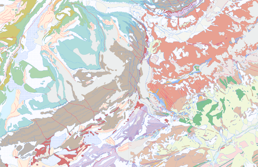
Geological Vector Datasets GeoCover
The GeoCover geological datasets are geodata representing the geology of the surface (2D) for the whole of Switzerland. These data, standardised according to the 2D Geological Data Model, are currently being updated (first update for the whole of Switzerland by the end of 2030). The progress of the update can be viewed in the <a href=" https://map.geo.admin.ch/?layers=ch.swisstopo.geologie-geocover.metadata&topic=geol" target="_blank">Division GeoCover</a>, which also contains metadata describing each of the datasets. For updated data, a brief report for each sheet concerned is available via the «Object information» tool in the «GeoCover» layer .
Simple
- Alternate title
-
GeoCover - Vector Datasets
- Date (Last Revision)
- 2022-04-01
- Identifier
- ch.swisstopo.geologie-geocover
- Presentation form
- Digital map
- Purpose
-
Detailliert Auskunft über den obersten Bereich des Untergrundes der Schweiz
- Status
- Completed
Point of contact
Owner
- Spatial representation type
- Vector
Spatial resolution
Equivalent scale
- Denominator
- 25000
- Topic category
-
- F Geoscientific information
Extent
Extent
- Description
-
National Map 1:25'000
- Geographic identifier
- NM25
))

- Maintenance and update frequency
- Continual
- Duration of Conservation
- 275
- Appraisal of Archival Value
- A
- Reason for Archiving Value
- Evidence of business practice
- geocat.ch
-
-
geologic map
-
Conservation and archiving planning AAP - Confederation
-
official geodata
-
opendata.swiss
-
- GEMET
-
-
geomorphology
-
sedimentation (geology)
-
tectonics
-
earth science
-
geological process
-
stone
-
- geocat.ch
-
-
FSDI Federal Spatial Data Infrastructure
-
Resource constraints
- Other constraints
-
NonCommercialAllowed-CommercialAllowed-ReferenceRequired
Associated resource
- Title
-
Geologisches Kartenwerk
- Association Type
- Reference to a master resource of which this one is a part
- Language
- Deutsch
- Character encoding
- UTF8
- Language
- Français
- Character encoding
- UTF8
- Language
- Italiano
- Character encoding
- UTF8
- Language
- English
- Character encoding
- UTF8
- Subtopic Category
- F1 Geology
- Basic Geodata
- true
- Basic Geodata ID
-
46.9
- Basic Geodata Legal Level
- Federal
- Basic Geodata Type
- basicGeodata
- Distribution format
-
-
ESRI Shapefile (SHP)
-
Digital transfer options
- OnLine resource
-
Vorschau map.geo.admin.ch
Preview map.geo.admin.ch
Digital transfer options
- OnLine resource
-
ch.swisstopo.geologie-geocover
WMS-FSDI service, layer "GeoCover - Vector Datasets"
Digital transfer options
- OnLine resource
-
ch.swisstopo.geologie-geocover
WMTS-FSDI service, layer "GeoCover - Vector Datasets"
Digital transfer options
Digital transfer options
Digital transfer options
- OnLine resource
-
RESTful API von geo.admin.ch
RESTful API from geo.admin.ch
- Statement
-
Bis der Geologischen Atlas der Schweiz 1:25'000 komplett erstellt und in Papierform verfügbar ist, kann die Qualität der Vektordatensätze entsprechend variieren.
- Hierarchy level
- Dataset
- Reference system identifier
- Referenzsystem entsprechend der zugrundeliegenden topographischen Karte (CH1903)
Metadata
- Metadata identifier
- 2467ab13-e794-4c13-8c55-59fe276398c5
- Language
- Deutsch
- Character encoding
- UTF8
- Language
- Français
- Character encoding
- UTF8
- Language
- Italiano
- Character encoding
- UTF8
- Language
- English
- Character encoding
- UTF8
- Language
- Rumantsch
- Character encoding
- UTF8
Point of contact
Type of resource
- Resource scope
- Dataset
- Metadata linkage
-
https://www.geocat.ch/geonetwork/srv/api/records/2467ab13-e794-4c13-8c55-59fe276398c5
- Date info (Creation)
- 2014-02-03T17:03:32Z
- Date info (Revision)
- 2026-04-13T09:30:17.450039Z
Metadata standard
- Title
-
eCH-0271