geocat.ch
Geologische Vektordatensätze GeoCover
Jeux de données géologiques vectorielles GeoCover
Set di dati geologici vettoriali GeoCover
Geological Vector Datasets GeoCover
Unitad da datas vectorialas geologicas GeoCover
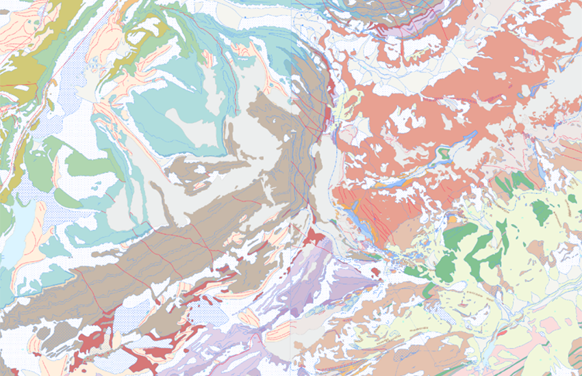
Die geologischen Datensätze GeoCover sind Geodaten, die die Geologie an der Oberfläche (2D) für das gesamte Gebiet der Schweiz darstellen. Diese Daten, die nach dem geologischen Datenmodell 2D standardisiert sind, werden derzeit aktualisiert (erste Aktualisierung für die gesamte Schweiz bis Ende 2030). Der Stand der Aktualisierung kann im Layer <a href=" https://map.geo.admin.ch/?layers=ch.swisstopo.geologie-geocover.metadata&topic=geol" target="_blank">Einteilung GeoCover</a> eingesehen werden, zusammen mit den Metadaten, die jeden Datensatz beschreiben. Für die aktualisierten Daten ist über das Werkzeug «Objektinformation» im Layer «GeoCover» ein kurzer Bericht für jedes betroffene Blatt verfügbar .
Les jeux de données géologiques GeoCover sont des géodonnées représentant la géologie en surface (2D) pour l’ensemble du territoire suisse. Ces données, standardisées selon le Modèle de données géologiques 2D, sont en cours d’actualisation (première actualisation pour toute la Suisse d’ici fin 2030). L’état d’avancement de l’actualisation peut être consulté sur la couche <a href=" https://map.geo.admin.ch/?layers=ch.swisstopo.geologie-geocover.metadata&topic=geol" target="_blank">Découpage GeoCover</a>, avec également les métadonnées décrivant chacun des jeux de données. Pour les données actualisées, un bref rapport pour chaque feuille concernée est disponible via l’outil «Information Objet» dans la couche «GeoCover ».
I set di dati geologici GeoCover sono geodati che rappresentano la geologia della superficie (2D) per l'intero territorio svizzero. Questi dati, standardizzati secondo il Modello di dati geologici 2D, sono in fase di aggiornamento (primo aggiornamento per tutta la Svizzera entro la fine del 2030). Lo stato di avanzamento dell'aggiornamento può essere consultato sul livello <a href=" https://map.geo.admin.ch/?layers=ch.swisstopo.geologie-geocover.metadata&topic=geol" target="_blank">Divisione GeoCover</a>, insieme ai metadati che descrivono ciascuno dei fogli. Per i dati aggiornati è disponibile una breve relazione per ogni foglio interessato tramite lo strumento «Informazioni oggetto» nel livello «GeoCover ».
The GeoCover geological datasets are geodata representing the geology of the surface (2D) for the whole of Switzerland. These data, standardised according to the 2D Geological Data Model, are currently being updated (first update for the whole of Switzerland by the end of 2030). The progress of the update can be viewed in the <a href=" https://map.geo.admin.ch/?layers=ch.swisstopo.geologie-geocover.metadata&topic=geol" target="_blank">Division GeoCover</a>, which also contains metadata describing each of the datasets. For updated data, a brief report for each sheet concerned is available via the «Object information» tool in the «GeoCover» layer .
Simple
-
Autre titreAltri nomi o acronimiAlternate titleAlternate titleAlternativtitel
-
GeoCover - Vektordaten
GeoCover - données vectorielles
GeoCover - dati vettoriali
GeoCover - Vector Datasets
GeoCover – datas vectorialas
-
Date (Dernière révision)Data (Ultima revisione)Date (Last Revision)Date (Last Revision)Datum (Letzte Überprüfung)
- 2022-04-01
-
IdentifiantIdentificatoreIdentifierIdentifierKennung
- ch.swisstopo.geologie-geocover
-
Forme de la présentationForma della presentazionePresentation formPresentation formPräsentationsform
-
Carte numériqueMappa digitaleDigital mapDigital mapDigitale Karte
-
ButScopoPurposePurposeZweck
-
Detailliert Auskunft über den obersten Bereich des Untergrundes der Schweiz
Renseignements détaillés sur les couches supérieures du sous-sol de la Suisse
-
ÉtatStatoStatusStatusBearbeitungsstatus
-
TerminéCompletatoCompletedCompletedAbgeschlossen
Point de contact
Punto di contatto
Point of contact
Point of contact
Ansprechpartner
Propriétaire
Proprietario
Owner
Owner
Eigentümer
-
Type de représentation spatialeTipo di rappresentazione spazialeSpatial representation typeSpatial representation typeRäumliche Darstellungsart
-
vecteurVettorialeVectorVectorVektor
Résolution spatiale
Risoluzione spaziale
Spatial resolution
Spatial resolution
Räumliche Auflösung
Fraction représentative
Frazione rappresentativa
Equivalent scale
Equivalent scale
Vergleichsmassstab
-
DénominateurDenominatoreDenominatorDenominatorMassstabszahl
- 25000
-
Catégorie de thèmeCategoria ISOTopic categoryTopic categoryThematik
-
-
F Informations géoscientifiquesF Informazioni geoscientificheF Geoscientific informationF Geoscientific informationF Erdwissenschaften
-
Étendue
Estensione
Extent
Extent
Ausdehnung
Étendue
Estensione
Extent
Extent
Ausdehnung
-
DescriptionDescrizioneDescriptionDescriptionBeschreibung
-
National Map 1:25'000
Landeskarte 1:25'000
Carte nationale 1:25'000
Carta nazionale 1:25'000
-
Identifiant géographiqueIdentificatore geograficoGeographic identifierGeographic identifierGeografische Kennung
- NM25LK25CN25CN25CN25
))

-
Fréquence de mise à jourFrequenza di aggiornamentoMaintenance and update frequencyMaintenance and update frequencyWartungsintervall
-
ContinueContinuaContinualContinualKontinuierlich
-
Durée de conservationDurata di conservazioneDuration of ConservationDuration of ConservationAufbewahrungsdauer NV in Jahren
- 275
-
Évaluation de la valeur archivistiqueValutazione del valore archivisticoAppraisal of Archival ValueAppraisal of Archival ValueBewertung Archivwürdigkeit
-
AAAAA
-
Raison de la valeur d'archivageMotivo del valore archivisticoReason for Archiving ValueReason for Archiving ValueBegründung Archivwürdigkeit
-
Preuve de la pratique couranteProva della pratica commercialeEvidence of business practiceEvidence of business practiceNachweis der Geschäftspraxis
- geocat.ch
-
-
carte géologique
carta geologica
geologic map
-
Planification de la conservation et de l'archivage AAP - Conféderation
Pianificazione della conservazione e dell’archiviazione AAP - Confederazione
Conservation and archiving planning AAP - Confederation
-
géodonnées de base
geodati di base
official geodata
-
opendata.swiss
opendata.swiss
opendata.swiss
opendata.swiss
-
- GEMET
-
-
géomorphologie
geomorfologia
geomorphology
-
sédimentation
sedimentazione (geologia)
sedimentation (geology)
-
tectonique
tettonica
tectonics
-
sciences de la terre
scienze della terra
earth science
-
processus géologique
processi geologici
geological process
-
pierre
pietra (edilizia)
stone
-
- GEMET - INSPIRE themes, version 1.0
-
-
Géologie
Geologia
Geology
-
- geocat.ch
-
-
BGDI Bundesgeodaten-Infrastruktur
IFDG l’Infrastructure Fédérale de données géographiques
IFDG Infrastruttura federale dei dati geografici
FSDI Federal Spatial Data Infrastructure
-
Contraintes sur la ressource
Vincoli sulle risorse
Resource constraints
Resource constraints
Ressourcenbeschränkungen
-
Autres contraintesAltri vincoliOther constraintsOther constraintsAndere Einschränkungen
-
Freie Nutzung. Quellenangabe ist Pflicht.
Utilisation libre. Obligation d’indiquer la source.
Libero utilizzo. Indicazione della fonte obbligatoria.
NonCommercialAllowed-CommercialAllowed-ReferenceRequired
Ressource associée
Risorsa associata
Associated resource
Associated resource
Verlinkte Ressource
-
TitreTitoloTitleTitleTitel
-
Geologisches Kartenwerk
Cartes géologiques
Carte geologiche
-
Type d'associationTipo di associazioneAssociation TypeAssociation TypeAssoziationstyp
-
Citation de travail plus largeCitazione di un'opera più ampiaReference to a master resource of which this one is a partReference to a master resource of which this one is a partÜbergeordneter Datenbestand
-
LangueLinguaLanguageLanguageSprache
- Deutsch
-
Encodage de caractèresCodifica dei caratteriCharacter encodingCharacter encodingZeichenkodierung
-
Utf8UTF8UTF8UTF8Utf8
-
LangueLinguaLanguageLanguageSprache
- Français
-
Encodage de caractèresCodifica dei caratteriCharacter encodingCharacter encodingZeichenkodierung
-
Utf8UTF8UTF8UTF8Utf8
-
LangueLinguaLanguageLanguageSprache
- Italiano
-
Encodage de caractèresCodifica dei caratteriCharacter encodingCharacter encodingZeichenkodierung
-
Utf8UTF8UTF8UTF8Utf8
-
LangueLinguaLanguageLanguageSprache
- English
-
Encodage de caractèresCodifica dei caratteriCharacter encodingCharacter encodingZeichenkodierung
-
Utf8UTF8UTF8UTF8Utf8
-
Catégorie de sous-thèmeCategoria di sottotemaSubtopic CategorySubtopic CategoryThematische Unterkategorien
-
F1 GéologieF1 GeologiaF1 GeologyF1 GeologyF1 Geologie
-
Géodonnées de baseGeodati di baseBasic GeodataBasic GeodataGeobasisdaten
- true
-
Identifiant Géodonnées de baseIdentificativo dei geodati di baseBasic Geodata IDBasic Geodata IDIdentifikator des Geobasisdatensatzes
-
46.9
-
Niveau des géodonnées de baseLivello legale dei geodati di baseBasic Geodata Legal LevelBasic Geodata Legal LevelGeobasisdatenebene
-
FédéralFederaleFederalFederalNational
-
Type de géodonnées de baseTipo di geodati di baseBasic Geodata TypeBasic Geodata TypeGeobasisdatentyp
-
basicGeodatabasicGeodatabasicGeodatabasicGeodatabasicGeodata
-
Format de distributionFormato (codifica)Distribution formatDistribution formatAbgabeformat
-
-
ESRI Shapefile (SHP)
-
Options de transfert numérique
Opzioni di trasferimento digitale
Digital transfer options
Digital transfer options
Optionen für die digitale Übertragung
-
Ressource en ligneRisorsa onlineOnLine resourceOnLine resourceOnline
-
Vorschau map.geo.admin.ch
Vorschau map.geo.admin.chAperçu map.geo.admin.chPrevisione map.geo.admin.chPreview map.geo.admin.ch
Options de transfert numérique
Opzioni di trasferimento digitale
Digital transfer options
Digital transfer options
Optionen für die digitale Übertragung
-
Ressource en ligneRisorsa onlineOnLine resourceOnLine resourceOnline
-
ch.swisstopo.geologie-geocover
WMS-BGDI Dienst, Layer "GeoCover - Vektordaten"Service WMS-IFDG, couche "GeoCover - données vectorielles"Servizio WMS-IFDG, strato "GeoCover - dati vettoriali"WMS-FSDI service, layer "GeoCover - Vector Datasets"WMS-BGDI Dienst, Layer "GeoCover - Vektordaten"
Options de transfert numérique
Opzioni di trasferimento digitale
Digital transfer options
Digital transfer options
Optionen für die digitale Übertragung
-
Ressource en ligneRisorsa onlineOnLine resourceOnLine resourceOnline
-
ch.swisstopo.geologie-geocover
WMTS-BGDI Dienst, Layer "GeoCover - Vektordaten"Service WMTS-IFDG, couche , Layer "GeoCover - données vectorielles"Servizio WMTS-IFDG, strato "GeoCover - dati vettoriali"WMTS-FSDI service, layer "GeoCover - Vector Datasets"WMTS-BGDI Dienst, Layer "GeoCover - Vektordaten"
Options de transfert numérique
Opzioni di trasferimento digitale
Digital transfer options
Digital transfer options
Optionen für die digitale Übertragung
Options de transfert numérique
Opzioni di trasferimento digitale
Digital transfer options
Digital transfer options
Optionen für die digitale Übertragung
Options de transfert numérique
Opzioni di trasferimento digitale
Digital transfer options
Digital transfer options
Optionen für die digitale Übertragung
-
Ressource en ligneRisorsa onlineOnLine resourceOnLine resourceOnline
-
RESTful API von geo.admin.ch
RESTful API von geo.admin.chRESTful API de geo.admin.chRESTful API da geo.admin.chRESTful API from geo.admin.chRESTful API dad geo.admin.ch
-
Généralités sur la provenanceInformazioni generali sulla provenienzaStatementStatementErklärung
-
Bis der Geologischen Atlas der Schweiz 1:25'000 komplett erstellt und in Papierform verfügbar ist, kann die Qualität der Vektordatensätze entsprechend variieren.
En attendant la rédaction complète de l'Atlas géologique 1:25'000 en format papier, la qualité des jeux de données vectorielles peut ainsi varier.
-
NiveauLivelloHierarchy levelHierarchy levelBezugsebene
-
Jeu de donnéesSet di datiDatasetDatasetDatenbestand
-
Nom du système de référenceNome del sistema di riferimentoReference system identifierReference system identifierName des Referenzsystems
- Referenzsystem entsprechend der zugrundeliegenden topographischen Karte (CH1903)
Metadata
-
Identifiant des métadonnéesIdentificativo della schedaMetadata identifierMetadata identifierIdentifikator des Metadatensatzes
- 2467ab13-e794-4c13-8c55-59fe276398c5
-
LangueLinguaLanguageLanguageSprache
- Deutsch
-
Encodage de caractèresCodifica dei caratteriCharacter encodingCharacter encodingZeichenkodierung
-
Utf8UTF8UTF8UTF8Utf8
-
LangueLinguaLanguageLanguageSprache
- Français
-
Encodage de caractèresCodifica dei caratteriCharacter encodingCharacter encodingZeichenkodierung
-
Utf8UTF8UTF8UTF8Utf8
-
LangueLinguaLanguageLanguageSprache
- Italiano
-
Encodage de caractèresCodifica dei caratteriCharacter encodingCharacter encodingZeichenkodierung
-
Utf8UTF8UTF8UTF8Utf8
-
LangueLinguaLanguageLanguageSprache
- English
-
Encodage de caractèresCodifica dei caratteriCharacter encodingCharacter encodingZeichenkodierung
-
Utf8UTF8UTF8UTF8Utf8
-
LangueLinguaLanguageLanguageSprache
- Rumantsch
-
Encodage de caractèresCodifica dei caratteriCharacter encodingCharacter encodingZeichenkodierung
-
Utf8UTF8UTF8UTF8Utf8
Point de contact
Punto di contatto
Point of contact
Point of contact
Ansprechpartner
Type de ressource
Tipo di risorsa
Type of resource
Type of resource
Anwendungsbereich der Metadaten
-
Domaine d'application de la ressourceAmbito di applicazione della risorsaResource scopeResource scopeDomäne der Ressourcenanwendung
-
Jeu de donnéesSet di datiDatasetDatasetDatenbestand
-
Lien vers la métadonnéeCollegamento ai metadatiMetadata linkageMetadata linkageLink zu den Metadaten
-
Informations de date (Création)Informazioni sulla data (Creazione)Date info (Creation)Date info (Creation)Datumsangaben (Erstellung)
- 2014-02-03T17:03:32Z
-
Informations de date (Révision)Informazioni sulla data (Revisione)Date info (Revision)Date info (Revision)Datumsangaben (Aktualisierung)
- 2026-04-13T09:30:17.450039Z
Norme des métadonnées
Standard dei metadati
Metadata standard
Metadata standard
Metadatenstandard
-
TitreTitoloTitleTitleTitel
-
eCH-0271