geocat.ch
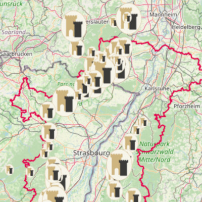
Interactive map - Tourism and Rhine castles
Interactive map of the castles of the Upper Rhine, based on data on accessibility, itinerary, tourist interest, ticketing and catering facilities. This project is co-financed by the EU as part of the Interreg VI project "Rhine castles - Burgen am Oberrhein".
At the crossroads of the German, Swiss and French borders lies one of the highest densities of castles in Europe, with more than 300 dominating the Rhine valley massifs. Witnesses of the Middle Ages, marked by Germanic influence, these castles, transformed or now in ruins, have resonated since the 19th century with legends and myths inherited from Romanticism.
"Châteaux rhénans – Burgen am Oberrhein" project website: www.chateaux-rhenans.eu
Simple
- Date (Publication)
- 2024-02-15T14:23:54
- Presentation form
- Digital map
- Status
- Completed
Point of contact
- mri:electronicMailAddress
- Topic category
-
- M Society
- Maintenance and update frequency
- Unknown
- Theme
-
-
Fortified castles
-
Castral heritage
-
Mviewer
-
Associated resource
- Association Type
- Reference to a master resource of which this one is a part
- Initiative Type
- Collection
- Metadata Reference
- Language
- Français
- Language
- Deutsch
- Distribution format
-
-
WMC
-
Digital transfer options
- OnLine resource
-
Interactive map "Rhine castles" in French
Digital transfer options
- OnLine resource
-
Interactive map "Rhine castles" in German
- Reference system identifier
- EPSG:3857
Metadata
- Metadata identifier
- 233140dc-e072-4eda-b612-9bbc1f8a5b1c
- Language
- Français
- Character encoding
- UTF8
- Language
- Deutsch
- Character encoding
- UTF8
- Language
- English
- Character encoding
- UTF8
Type of resource
- Resource scope
- interactiveMap
- Name
-
Parent
- Date info (Revision)
- 2025-11-12T07:37:24.836127Z
Metadata standard
- Title
-
ISO 19115-3:2018
- Edition
-
1.0