geocat.ch
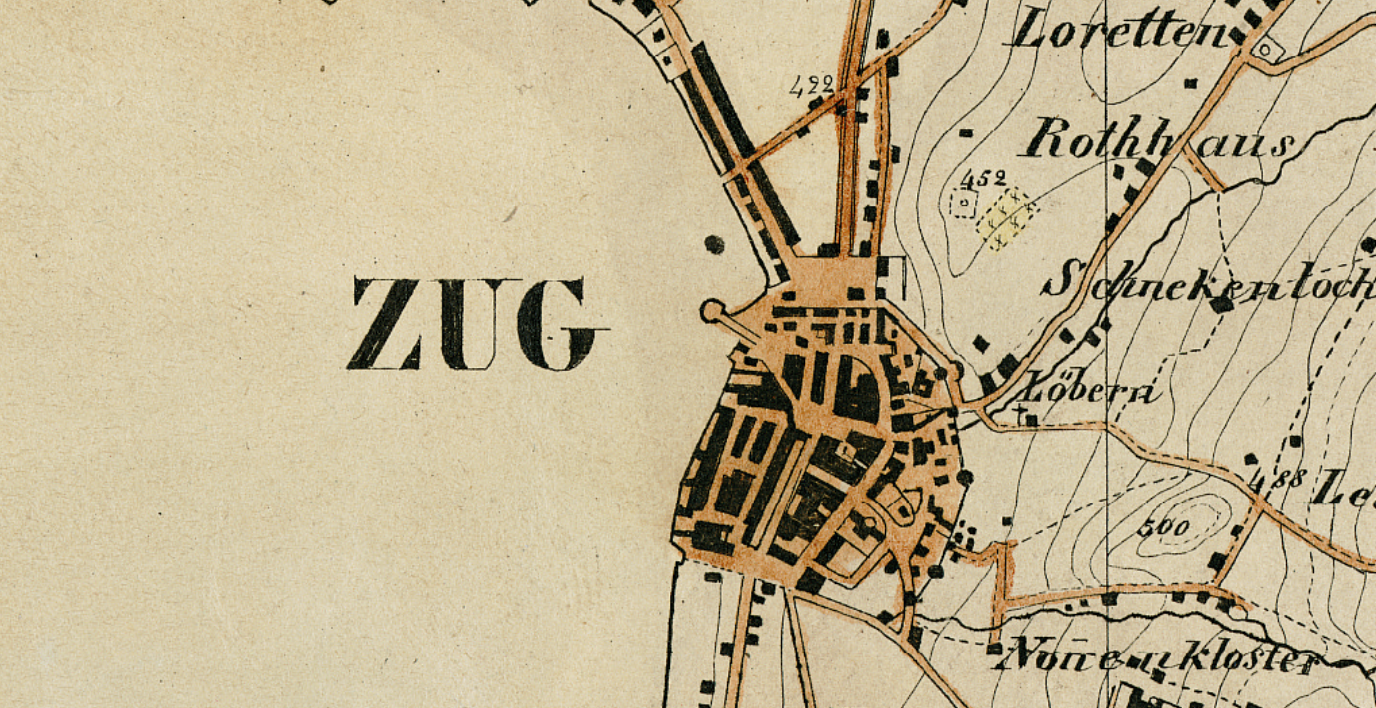
Anselmierkarte 1845 (ZG)
Die Anselmierkarte 1845 ist eine historische topographische Karte des damaligen Standes Zug. Sie wurde von Jules Anselmier erstellt und dokumentiert die Siedlungsstruktur, Verkehrswege, Gewässer, Geländeformen sowie weitere topographische Elemente des Kantons Zug in der Mitte des 19. Jahrhunderts.
Der Datensatz dient der historischen Raum- und Landschaftsanalyse sowie dem Vergleich mit heutigen Geodatenbeständen. Er eignet sich für Anwendungen in den Bereichen Geschichte, Raumplanung, Denkmalpflege, Landschaftsentwicklung, Forschung und Bildung.
Die Karte wird als digitalisierte historische Kartengrundlage bereitgestellt und bildet den Wissensstand sowie die topographischen Verhältnisse des Jahres 1845 ab. Die Inhalte entsprechen einem historischen Quellenwerk und werden nicht nachgeführt.
Simple
-
Date (Création)Data (Creazione)Date (Creation)Datum (Erstellung)
- 1845-01-01
-
ÉtatStatoStatusBearbeitungsstatus
-
Archive historiqueArchivio storicoHistorical archiveHistorisches Archiv
Propriétaire
Proprietario
Owner
Eigentümer
-
Heures de serviceOrario di servizioHours of serviceBetriebszeiten
-
08:00-11:45, 13:30-17:00
-
Type de représentation spatialeTipo di rappresentazione spazialeSpatial representation typeRäumliche Darstellungsart
-
grilleRasterGridRaster, Gitter
-
Catégorie de thèmeCategoria ISOTopic categoryThematik
-
-
A Imagerie, cartes de base et occupation du solA Mappe di base con immagini della copertura terrestreA Imagery base maps earth coverA Oberflächenbeschreibung
-
Étendue
Estensione
Extent
Ausdehnung
Étendue
Estensione
Extent
Ausdehnung
-
DescriptionDescrizioneDescriptionBeschreibung
-
Kanton Zug (ZG)
))

-
Fréquence de mise à jourFrequenza di aggiornamentoMaintenance and update frequencyWartungsintervall
-
Non planifiéeNon pianificatoNot plannedNicht geplant
- geocat.ch
-
-
carte historique
carta storica
historic map
-
- GEMET
-
-
évolution historique
evoluzione storica
historical evolution
-
histoire
storia
history
-
recherche historique
ricerca storica
historical research
-
patrimoine culturel
patrimonio culturale
cultural heritage
-
-
LangueLinguaLanguageSprache
- Deutsch
-
Encodage de caractèresCodifica dei caratteriCharacter encodingZeichenkodierung
-
Utf8UTF8UTF8Utf8
Options de transfert numérique
Opzioni di trasferimento digitale
Digital transfer options
Optionen für die digitale Übertragung
-
Ressource en ligneRisorsa onlineOnLine resourceOnline
-
Anselmierkarte (WMS)
Darstellungsdienst WMSDarstellungsdienst WMSDarstellungsdienst WMS
Identifiant
Identificativo
Identifier
Identifikator
-
CodeCodiceCodeCode
- EPSG:2056
-
DescriptionDescrizioneDescriptionBeschreibung
-
CH1903+ / LV95 (EPSG:2056)
Metadata
-
Identifiant des métadonnéesIdentificativo della schedaMetadata identifierIdentifikator des Metadatensatzes
- 1ebee31d-cb98-4577-9757-ef99408da852
-
LangueLinguaLanguageSprache
- Deutsch
-
Encodage de caractèresCodifica dei caratteriCharacter encodingZeichenkodierung
-
Utf8UTF8UTF8Utf8
-
LangueLinguaLanguageSprache
- Français
-
Encodage de caractèresCodifica dei caratteriCharacter encodingZeichenkodierung
-
Utf8UTF8UTF8Utf8
-
LangueLinguaLanguageSprache
- Italiano
-
Encodage de caractèresCodifica dei caratteriCharacter encodingZeichenkodierung
-
Utf8UTF8UTF8Utf8
-
LangueLinguaLanguageSprache
- English
-
Encodage de caractèresCodifica dei caratteriCharacter encodingZeichenkodierung
-
Utf8UTF8UTF8Utf8
Distributeur
Distributore
Distributor
Verteiler
-
Heures de serviceOrario di servizioHours of serviceBetriebszeiten
-
08:00-11:45, 13:30-17:00
Type de ressource
Tipo di risorsa
Type of resource
Anwendungsbereich der Metadaten
-
Domaine d'application de la ressourceAmbito di applicazione della risorsaResource scopeDomäne der Ressourcenanwendung
-
Jeu de donnéesSet di datiDatasetDatenbestand
-
Informations de date (Révision)Informazioni sulla data (Revisione)Date info (Revision)Datumsangaben (Aktualisierung)
- 2026-06-16T12:33:46.296421Z
-
Informations de date (Création)Informazioni sulla data (Creazione)Date info (Creation)Datumsangaben (Erstellung)
- 2026-06-11T13:30:15.791792Z
Norme des métadonnées
Standard dei metadati
Metadata standard
Metadatenstandard
-
TitreTitoloTitleTitel
-
eCH-0271