 geocat.ch
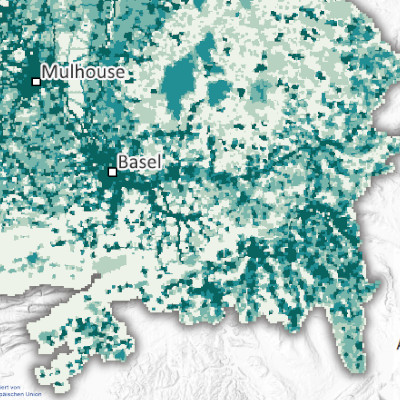
Black carbon emissions per 500 m grid cell in the Upper Rhine region (2021)
Produced as part of the Interreg Upper Rhine Atmo-Rhena PLUS project, this map shows black carbon emissions in the Upper Rhine region in 2021.
Limiting air pollutant emissions is the most important lever for reducing pollutant concentrations in the atmosphere. Air pollutants are gaseous compounds or particles that have a negative impact on air quality and harm human health and the environment. Their negative effects are not limited to the area close to the emission sources, but can spread in the atmosphere over hundreds of kilometres, and sometimes even globally.
Black carbon is a particulate compound consisting solely of carbon atoms. It accounts for 5 to 15% of the mass of PM2.5 fine particles. Black carbon is emitted by the incomplete combustion of fuel, mainly diesel, and biomass. In the Upper Rhine region, road transport and the residential sector (wood heating) are the main sources. This carbon content of particles is a more accurate health indicator than the overall measurement of PM2.5 fine particles.
The static map in PDF format is available at a scale of 500m. The data is accessible as open data only at the scale of EPCI, Kreis and Cantons.
Simple
- Date (Creation)
- 2025-08-07
- Date (Publication)
- 2025-11-07
- Identifier
- AtmoRhenaPlus_bc
- Status
- Completed
Point of contact
- mri:deliveryPoint
-
100, avenue d'Alsace
- mri:city
-
COLMAR
- mri:postalCode
-
68000
- Country
-
FRANCE
- mri:electronicMailAddress
Point of contact
- mri:deliveryPoint
-
5, rue de Madrid
- mri:city
-
Schiltigheim
- mri:postalCode
-
67300
- Country
-
France
- mri:electronicMailAddress
Point of contact
- mri:deliveryPoint
-
Griesbachstraße 1
- mri:city
-
Kalrsruhe
- mri:postalCode
-
76185
- mri:electronicMailAddress
Point of contact
- mri:deliveryPoint
-
Rheinstrasse 29
- mri:city
-
Liestal
- mri:postalCode
-
4410
- mri:electronicMailAddress
Point of contact
- mri:deliveryPoint
-
Kaiser-Friedrich-Straße 7
- mri:city
-
Mainz/Rhein
- mri:postalCode
-
55116
- mri:electronicMailAddress
Point of contact
- mri:deliveryPoint
-
Bel'Oiseau 12, Case postale 69
- mri:city
-
Saint-Ursanne
- mri:postalCode
-
2882
- mri:electronicMailAddress
Point of contact
- mri:deliveryPoint
-
Entfelderstrasse 22
- mri:city
-
Aarau
- mri:postalCode
-
5001
- mri:electronicMailAddress
- Spatial representation type
- Vector
Spatial resolution
Equivalent scale
- Denominator
- 50000
- Topic category
-
- L Environment
- N Health
Extent
Extent
Temporal extent
- Time period
- 2020-01-01 2021-12-31
Extent
Extent
))
- Maintenance and update frequency
- Not planned
- Theme
-
-
Upper Rhine
-
Crossborder
-
Resource constraints
- Use limitation
-
CC-BY Licence ©OpenStreetMap contributors ©GeoRhena
Resource constraints
- Access constraints
- Other restrictions
- Use constraints
- Other restrictions
- Other constraints
-
No other limitation
- Language
- Français
- Character encoding
- UTF8
- Language
- Deutsch
- Character encoding
- UTF8
- Language
- English
- Character encoding
- UTF8
Digital transfer options
- OnLine resource
-
0
Black carbon emissions
Digital transfer options
- OnLine resource
-
Black carbon emissions
Digital transfer options
- OnLine resource
-
Upper Rhine Air Quality Portal
Digital transfer options
- OnLine resource
-
Black carbon emissions per 500m grid
Digital transfer options
- OnLine resource
-
Upper Rhine Air-Climate-Energy Dashboard
- Statement
-
Collection of estimated emissions for the Grand Est region (ATMO Grand Est), Baden-Württemberg (Landesanstalt für Umwelt Baden-Württemberg – LUBW), the cantons of Basel-Stadt and Basel-Landschaft (Lufthygienamt Beider Basel – LHA), Rhineland-Palatinate (Landesamt für Umwelt Rheinland-Pfalz – LfU), the Canton of Jura (Office de l'environnement - ENV Jura) and the Canton of Aargau (Departement Bau, Verkehr und Umwelt – BVU Aargau). Data from the cantons of Jura, Aargau and Solothurn were registered based on cantonal or municipal data. Application of BC/PM2.5 speciation in the event of missing data.
- Hierarchy level
- staticMap
Metadata
- Metadata identifier
- 1db3f795-0ae9-41de-a020-166174432d57
- Language
- Français
- Character encoding
- UTF8
- Language
- English
- Character encoding
- UTF8
- Language
- Deutsch
- Character encoding
- UTF8
Contact
- mdb:deliveryPoint
-
100, avenue d'Alsace
- mdb:city
-
COLMAR
- mdb:postalCode
-
68000
- mdb:country
-
FR
Type of resource
- Resource scope
- staticMap
- Date info (Revision)
- 2025-11-07T09:23:43.720084Z
Metadata standard
- Title
-
ISO 19115-3:2018
- Edition
-
1.0
)))