 geocat.ch
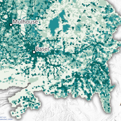
Emissions de black carbon par maille de 500m dans le Rhin supérieur (2021)
Black carbon emissions per 500 m grid cell in the Upper Rhine region (2021)
Black Carbon-Emissionen pro 500m Rasterzelle am Oberrhein (2021)
Produite dans le cadre du projet Interreg Rhin Supérieur Atmo-Rhena PLUS, cette carte représente les émissions de black carbon sur le territoire du Rhin supérieur en 2021.
La limitation des émissions de polluants atmosphériques est le levier le plus important pour réduire les concentrations de polluants dans l'atmosphère. Les polluants atmosphériques sont des composés gazeux ou des particules qui ont un impact négatif sur la qualité de l'air et nuisent à la santé humaine et à l'environnement. Leurs effets négatifs ne se limitent pas à la zone proche des sources d'émission, mais peuvent se propager dans l'atmosphère sur des centaines de kilomètres, voire parfois à l'échelle mondiale.
Le Black Carbon (carbone-suie en français) est un composé des particules, constitué uniquement d’atomes de carbone. Il représente 5 à 15 % de la masse des particules fines PM2,5. Le Black Carbon est émis par la combustion incomplète de carburant, diesel principalement, et de la biomasse. Dans le Rhin supérieur, le transport routier et le secteur résidentiel (chauffage au bois) sont les sources majoritaires. Cette part carbonée des particules est un indicateur sanitaire plus précis que la mesure globale des particules fines PM2,5.
La carte statique au format PDF est disponible à une échelle de 500 m. Les données sont accessibles en tant que données ouvertes uniquement à l'échelle de l'EPCI, des cantons et des districts.
Produced as part of the Interreg Upper Rhine Atmo-Rhena PLUS project, this map shows black carbon emissions in the Upper Rhine region in 2021.
Limiting air pollutant emissions is the most important lever for reducing pollutant concentrations in the atmosphere. Air pollutants are gaseous compounds or particles that have a negative impact on air quality and harm human health and the environment. Their negative effects are not limited to the area close to the emission sources, but can spread in the atmosphere over hundreds of kilometres, and sometimes even globally.
Black carbon is a particulate compound consisting solely of carbon atoms. It accounts for 5 to 15% of the mass of PM2.5 fine particles. Black carbon is emitted by the incomplete combustion of fuel, mainly diesel, and biomass. In the Upper Rhine region, road transport and the residential sector (wood heating) are the main sources. This carbon content of particles is a more accurate health indicator than the overall measurement of PM2.5 fine particles.
The static map in PDF format is available at a scale of 500m. The data is accessible as open data only at the scale of EPCI, Kreis and Cantons.
Diese Karte wurde im Rahmen des Interreg-Projekts Oberrhein Atmo-Rhena PLUS erstellt und stellt die Black-Carbon-Emissionen im Oberrheingebiet dar.
Die Begrenzung der Luftschadstoffemissionen ist der wichtigste Hebel, um die Schadstoffkonzentrationen in der Atmosphäre zu verringern. Als Luftschadstoffe werden gasförmige Verbindungen oder Partikel bezeichnet, die die Luftqualität negativ beeinflussen und die menschliche Gesundheit sowie die Umwelt schädigen. Die negativen Auswirkungen der Luftschadstoffe begrenzen sich nicht nur auf den Umkreis der Emissionen, sondern können in der Atmosphäre über hunderte Kilometer transportiert werden, manchmal sogar über den gesamten Globus.
Black Carbon (Ruß) ist eine Partikelverbindung, die ausschließlich aus Kohlenstoffatomen besteht. Ruß kann 5 bis 15 % der Feinstaubmasse von PM2,5 ausmachen. Er wird bei der unvollständigen Verbrennung von Kraft- und Brennstoffen (vor allem Diesel und Biomasse) freigesetzt. In der Oberrheinregion stellt die Kraftstoffverbrennung im Verkehrssektor und von Biomasse in Haushalten (Holzfeuerung) die Hauptquelle von Black Carbon dar. Dieser Kohlenstoffanteil der Partikel ist als Gesundheitsindikator besser geeignet als die Messung der Feinstaubpartikel PM2,5.
Die statische Karte im PDF-Format ist im Maßstab 500 m verfügbar. Die Daten sind als Open Data nur im Maßstab der EPCI, Kreise und Kantone zugänglich.
Simple
-
Date (Creation)Datum (Erstellung)Date (Création)
- 2025-08-07
-
Date (Publication)Datum (Publikation)Date (Publication)
- 2025-11-07
-
IdentifierKennungIdentifiant
- AtmoRhenaPlus_bc
-
StatusBearbeitungsstatusÉtat
-
CompletedAbgeschlossenTerminé
Point of contact
Kontakt für die Ressource
Contact pour la ressource
-
mri:deliveryPointmri:deliveryPointmri:deliveryPoint
-
100, avenue d'Alsace
100, avenue d'Alsace
100, avenue d'Alsace
-
mri:citymri:citymri:city
-
COLMAR
-
mri:postalCodemri:postalCodemri:postalCode
-
68000
-
Countrymri:countrymri:country
-
FRANCE
FRANCE
FRANCE
-
mri:electronicMailAddressmri:electronicMailAddressmri:electronicMailAddress
Point of contact
Kontakt für die Ressource
Contact pour la ressource
-
mri:deliveryPointmri:deliveryPointmri:deliveryPoint
-
5, rue de Madrid
-
mri:citymri:citymri:city
-
Schiltigheim
-
mri:postalCodemri:postalCodemri:postalCode
-
67300
-
Countrymri:countrymri:country
-
France
-
mri:electronicMailAddressmri:electronicMailAddressmri:electronicMailAddress
Point of contact
Kontakt für die Ressource
Contact pour la ressource
Point of contact
Kontakt für die Ressource
Contact pour la ressource
-
mri:deliveryPointmri:deliveryPointmri:deliveryPoint
-
Rheinstrasse 29
-
mri:citymri:citymri:city
-
Liestal
-
mri:postalCodemri:postalCodemri:postalCode
-
4410
-
mri:electronicMailAddressmri:electronicMailAddressmri:electronicMailAddress
Point of contact
Kontakt für die Ressource
Contact pour la ressource
-
mri:deliveryPointmri:deliveryPointmri:deliveryPoint
-
Kaiser-Friedrich-Straße 7
-
mri:citymri:citymri:city
-
Mainz/Rhein
-
mri:postalCodemri:postalCodemri:postalCode
-
55116
-
mri:electronicMailAddressmri:electronicMailAddressmri:electronicMailAddress
Point of contact
Kontakt für die Ressource
Contact pour la ressource
-
mri:deliveryPointmri:deliveryPointmri:deliveryPoint
-
Bel'Oiseau 12, Case postale 69
-
mri:citymri:citymri:city
-
Saint-Ursanne
-
mri:postalCodemri:postalCodemri:postalCode
-
2882
-
mri:electronicMailAddressmri:electronicMailAddressmri:electronicMailAddress
Point of contact
Kontakt für die Ressource
Contact pour la ressource
-
Spatial representation typeRäumliche DarstellungsartType de représentation spatiale
-
VectorVektorvecteur
Spatial resolution
Räumliche Auflösung
Résolution spatiale
Equivalent scale
Vergleichsmassstab
Fraction représentative
-
DenominatorMassstabszahlDénominateur
- 50000
-
Topic categoryThematikCatégorie de thème
-
-
L EnvironmentL UmweltL Environnement
-
N HealthN GesundheitN Santé
-
Extent
Ausdehnung
Étendue
Extent
Ausdehnung
Étendue
Temporal extent
Zeitlicher Umfang
Étendue temporelle
-
Time periodZeitraumPériode
- 2020-01-01 2021-12-31
Extent
Ausdehnung
Étendue
Extent
Ausdehnung
Étendue
))
-
Maintenance and update frequencyWartungsintervallFréquence de mise à jour
-
Not plannedNicht geplantNon planifiée
-
ThemeThemaThème
-
-
Rhin Supérieur
Upper Rhine
Oberrhein
-
Transfrontalier
Crossborder
Grenzüberschreitend
-
Resource constraints
Ressourcenbeschränkungen
Contraintes sur la ressource
-
Use limitationNutzungsbeschränkungLimitation d'utilisation
-
Licence ODbL V1.0
CC-BY Licence ©OpenStreetMap contributors ©GeoRhena
CC-BY Lizenz ©OpenStreetMap contributors ©GeoRhena
Resource constraints
Ressourcenbeschränkungen
Contraintes sur la ressource
-
Access constraintsZugriffsbeschränkungenContraintes d'accès
-
Other restrictionsAndere BeschränkungenAutres restrictions
-
Use constraintsNutzungseinschränkungenContraintes d'utilisation
-
Other restrictionsAndere BeschränkungenAutres restrictions
-
Other constraintsAndere EinschränkungenAutres contraintes
-
Pas d'autre limitation
No other limitation
Keine andere Einschränkung
-
LanguageSpracheLangue
- Français
-
Character encodingZeichenkodierungEncodage de caractères
-
UTF8Utf8Utf8
-
LanguageSpracheLangue
- Deutsch
-
Character encodingZeichenkodierungEncodage de caractères
-
UTF8Utf8Utf8
-
LanguageSpracheLangue
- English
-
Character encodingZeichenkodierungEncodage de caractères
-
UTF8Utf8Utf8
Digital transfer options
Optionen für die digitale Übertragung
Options de transfert numérique
-
OnLine resourceOnlineRessource en ligne
-
0
Emissions de black carbonBlack carbon emissionsBlack-Carbon-Emissionen
Digital transfer options
Optionen für die digitale Übertragung
Options de transfert numérique
-
OnLine resourceOnlineRessource en ligne
-
Emissions de black carbon
Black carbon emissions
Black-Carbon-Emissionen
Digital transfer options
Optionen für die digitale Übertragung
Options de transfert numérique
-
OnLine resourceOnlineRessource en ligne
-
Portail Qualité de l’air du le Rhin supérieur
Upper Rhine Air Quality Portal
Luftqualitätsportal Oberrhein
Digital transfer options
Optionen für die digitale Übertragung
Options de transfert numérique
-
OnLine resourceOnlineRessource en ligne
-
Emissions de black carbon par maille de 500m
Black carbon emissions per 500m grid
Black-Carbon-Emissionen pro 500m-mesh
Digital transfer options
Optionen für die digitale Übertragung
Options de transfert numérique
-
OnLine resourceOnlineRessource en ligne
-
Tableau de bord Air-Climat-Energie du Rhin supérieur
Upper Rhine Air-Climate-Energy Dashboard
Dashboard Luft-Klima-Energie am Oberrhein
-
StatementErklärungGénéralités sur la provenance
-
Collecte des émissions estimées pour la région Grand Est (ATMO Grand Est), le Bade Wurtemberg (Landesanstalt für Umwelt Bade-Wurtemberg – LUBW), les Cantons de Bâle Ville et Bâle Campagne (Lufthygienamt Beider Basel – LHA), la Rhénanie Palatinat (Landesamt für Umwelt Rheinland-Pfalz – LfU), le Canton du Jura (Office de l'environnement - ENV Jura) et le Canton Argovie (Departement Bau, Verkehr und Umwelt – BVU Aargau). Les données des cantons du Jura, d'Argovie et de Soleure ont été cadastrées à partir de données cantonales ou communales. Application d’une spéciation BC/PM2.5 en cas de données manquantes.
Collection of estimated emissions for the Grand Est region (ATMO Grand Est), Baden-Württemberg (Landesanstalt für Umwelt Baden-Württemberg – LUBW), the cantons of Basel-Stadt and Basel-Landschaft (Lufthygienamt Beider Basel – LHA), Rhineland-Palatinate (Landesamt für Umwelt Rheinland-Pfalz – LfU), the Canton of Jura (Office de l'environnement - ENV Jura) and the Canton of Aargau (Departement Bau, Verkehr und Umwelt – BVU Aargau). Data from the cantons of Jura, Aargau and Solothurn were registered based on cantonal or municipal data. Application of BC/PM2.5 speciation in the event of missing data.
Messungen der Netzwerke zur Überwachung der Luftqualität in der Region Grand Est (ATMO Grand Est), in Baden-Württemberg (Landesanstalt für Umwelt Baden-Württemberg – LUBW), in den Kantonen Basel-Stadt und Basel-Landschaft (Lufthygienamt Beider Basel – LHA), in Rheinland-Pfalz (Landesamt für Umwelt Rheinland-Pfalz – LfU). den Kanton Jura (Office de l'environnement - ENV Jura) und den Kanton Aargau (Departement Bau, Verkehr und Umwelt – BVU Aargau). Die Daten der Kantone Jura, Aargau und Solothurn wurden anhand von kantonalen oder kommunalen Daten katasterisiert. Anwendung einer BC/PM2.5-Spezies bei fehlenden Daten
-
Hierarchy levelBezugsebeneNiveau
-
staticMapstaticMapstaticMap
Metadata
-
Metadata identifierIdentifikator des MetadatensatzesIdentifiant des métadonnées
- 1db3f795-0ae9-41de-a020-166174432d57
-
LanguageSpracheLangue
- Français
-
Character encodingZeichenkodierungEncodage de caractères
-
UTF8Utf8Utf8
-
LanguageSpracheLangue
- English
-
Character encodingZeichenkodierungEncodage de caractères
-
UTF8Utf8Utf8
-
LanguageSpracheLangue
- Deutsch
-
Character encodingZeichenkodierungEncodage de caractères
-
UTF8Utf8Utf8
Contact
Kontaktstelle für Metadaten
Point de contact des métadonnées
-
mdb:deliveryPointmdb:deliveryPointmdb:deliveryPoint
-
100, avenue d'Alsace
100, avenue d'Alsace
100, avenue d'Alsace
-
mdb:citymdb:citymdb:city
-
COLMAR
-
mdb:postalCodemdb:postalCodemdb:postalCode
-
68000
-
mdb:countrymdb:countrymdb:country
-
FR
FR
FR
Type of resource
Anwendungsbereich der Metadaten
Type de ressource
-
Resource scopeDomäne der RessourcenanwendungDomaine d'application de la ressource
-
staticMapstaticMapstaticMap
-
Date info (Revision)Datumsangaben (Aktualisierung)Informations de date (Révision)
- 2025-11-07T09:23:43.720084Z
Metadata standard
Metadatenstandard
Norme des métadonnées
-
TitleTitelTitre
-
ISO 19115-3:2018
-
EditionAusgabeÉdition
-
1.0
)))