geocat.ch
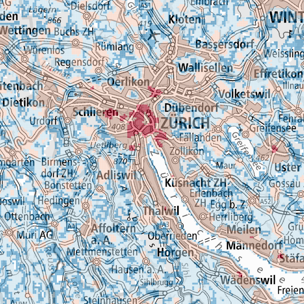
SORA - Map for intrinsic ground risk
European unmanned aircraft regulation (EU) 2019/947 Article 11 requires a SORA (Specific Operational Risk Assessment) to be performed for flights which fit into the Specific category of UAS. One part of this risk assessment is to assess the risk to overflown uninvolved people and this map is tailored for the use in this risk assessment methodology. The map shows the estimated average population density, derived from data on the population (STATPOP) and employment (STATENT) provided by the Federal Statistical Office (FSO). In addition, where no swiss data was available, information from the Global Human Settlement Layer (GHSL) of the Euroean Commission was used. The data should be used as a guideline, meaning that discrepancies can be argued accordingly by the applicant in the SORA risk assessment.
The extent of the map is anywhere the Federal Office of Civil Aviation has authority to grant UAS authorizations which is within Switzerland and Liechtenstein. Further, the data extends 5 km beyond the Swiss border into the surrounding countries to allow a proper fly-away risk assesment of flights very close to the borders.
The map is provided with a resolution of 100m or 200m, depending on the flight altitude.
Simple
- Alternate title
-
SORA Ground Risk
- Date (Creation)
- 2023-09-06T00:00:00
- Date (Publication)
- 2023-06-28T00:00:00
- Identifier
- ch.bazl.intrinsisches-bodenrisiko_sora
- Status
- On going
Point of contact
Spatial resolution
Equivalent scale
- Denominator
- 5000
Spatial resolution
Equivalent scale
- Denominator
- 1000000
- Topic category
-
- P Transportation
Extent
Extent
- Description
-
Switzerland
))

Extent
Extent
- Description
-
Liechtenstein
))

- Maintenance and update frequency
- Unknown
Resource format
- Title
-
OGC Geopackage (GPKG)
- Date
- geocat.ch
-
-
air navigation
-
opendata.swiss
-
airspace
-
- GEMET
-
-
aircraft
-
- geocat.ch
-
-
FSDI Federal Spatial Data Infrastructure
-
Resource constraints
- Use constraints
- Other restrictions
- Other constraints
- Opendata BY: Open use. Must provide the source.
- Other constraints
- Language
- Deutsch
- Character encoding
- UTF8
- Language
- Français
- Character encoding
- UTF8
- Language
- Italiano
- Character encoding
- UTF8
- Language
- English
- Character encoding
- UTF8
- Distribution format
-
-
OGC Geopackage (GPKG)
-
Digital transfer options
- OnLine resource
-
Vorschau map.geo.admin.ch
Preview map.geo.admin.ch
Digital transfer options
- OnLine resource
-
ch.bazl.intrinsisches-bodenrisiko_sora
WMS-FSDI service, layer "SORA Ground Risk"
Digital transfer options
- OnLine resource
-
ch.bazl.intrinsisches-bodenrisiko_sora
WMTS-FSDI service, layer "SORA Ground Risk"
Digital transfer options
Digital transfer options
- Geometric object type
- Surface
- Reference system identifier
- EPSG:2056
Metadata
- Metadata identifier
- 1d83faa1-04d8-4424-a3ec-b9150fa89f0c
- Language
- Deutsch
- Character encoding
- UTF8
- Language
- Français
- Character encoding
- UTF8
- Language
- Italiano
- Character encoding
- UTF8
- Language
- English
- Character encoding
- UTF8
- Language
- Rumantsch
- Character encoding
- UTF8
Point of contact
Type of resource
- Resource scope
- Dataset
- Metadata linkage
-
https://www.geocat.ch/geonetwork/srv/api/records/1d83faa1-04d8-4424-a3ec-b9150fa89f0c
- Date info (Creation)
- 2023-04-11T13:09:28.962Z
- Date info (Revision)
- 2026-04-13T09:48:11.075232Z
Metadata standard
- Title
-
eCH-0271