 geocat.ch
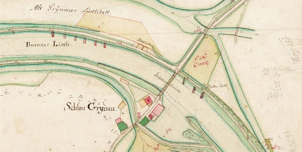
Linthplan Legler 1857
Gottlieb Heinrich Legler: Plan der Linth, Blatt I-IX. Situationsplan 1:2'000, 1857. Federzeichnung, koloriert, LIAR F II.01 Mappe 4
Simple
- Date (Creation)
- 2017-05-08
- Date (Revision)
- 2026-06-21
- Other citation details
-
Basiskarten, Landschaftsmodelle
- Purpose
-
-
partner
- Hours of service
-
Mo. - Fr. von 8:00 - 17:00 Uhr
- Spatial representation type
- Grid
Spatial resolution
Equivalent scale
- Denominator
- 2000
Extent
Extent
- Description
-
Kanton St.Gallen und angrenzende Gebiete
))
- Maintenance and update frequency
- Irregular
- geocat.ch
-
-
Historische Karte
-
opendata.swiss
-
Resource constraints
- Access constraints
- Other restrictions
- Other constraints
-
A = öffentlich
Resource constraints
- Classification
- Unclassified
- Language
- Deutsch
- Subtopic Category
- A1 Base Maps, Landscape Models
- Distribution format
-
-
GeoTIFF
-
Distributor
- Hours of service
-
Mo. - Fr. von 8:00 - 17:00 Uhr
Digital transfer options
- Statement
-
Im Lintharchiv befinden sich zwei vollständige Plansätze der Linthkorrektion. Diese sogenannten Legler- und Salvetti-Pläne zeigen den Verlauf von Escher- und Linthkanal von Netstal über den Walensee bis zum Zürichsee im Massstab 1:2'000 in den Jahren 1843 und 1857. Es handelt sich um 15 bzw. 9 Messtischblätter, auf denen die damals geplanten Baumassnahmen in grosser Präzision eingetragen sind.
- Hierarchy level
- Dataset
- Reference system identifier
- CH1903+_LV95 / EPSG 2056
Metadata
- Metadata identifier
- 1804b4bb-035e-434b-9801-4f7a96ce34cd-8371
- Language
- Deutsch
- Character encoding
- UTF8
Resource provider
- Hours of service
-
Mo. - Fr. von 8:00 - 17:00 Uhr
Type of resource
- Resource scope
- Dataset
- Date info (Revision)
- 2026-06-21T01:15:28+02:00
Metadata standard
- Title
-
GM03 Core
)))
