 geocat.ch
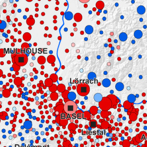
Evolution of the communal population (2006 - 2013) in percentage
This map shows the percentage change in the municipal population between 2006 and 2013 in the Upper Rhine area.
Simple
- Date (Creation)
- 2016-04-01
- Date (Publication)
- 2016-04-01
- Identifier
- 05_2016_0229_0
- Status
- Completed
Point of contact
- mri:deliveryPoint
-
100, avenue d'Alsace
- mri:city
-
COLMAR
- mri:postalCode
-
68000
- Country
-
FRANCE
- mri:electronicMailAddress
-
GeoRhena
Spatial resolution
Equivalent scale
- Denominator
- 100000
- Topic category
-
- M Society
Extent
Extent
Temporal extent
- Time period
- 2006-01-29 2013-12-31
Extent
Extent
N
S
E
W
))
- Maintenance and update frequency
- Not planned
- Keywords
-
-
Map
-
- Keywords
-
-
Upper Rhine
-
- GEMET - Concepts, version 2.4
-
-
demography
-
inhabitant
-
Resource constraints
- Use limitation
-
Licence CC BY
Resource constraints
- Access constraints
- Other restrictions
- Use constraints
- Other restrictions
- Other constraints
-
No other limitation
- Language
- Français
- Character encoding
- UTF8
- Distribution format
-
-
PDF Map
-
Digital transfer options
- OnLine resource
-
Pdf Download
Metadata
- Metadata identifier
- 17553393-79eb-4124-9c8c-3b72edd03249
- Language
- Français
- Character encoding
- UTF8
- Language
- Deutsch
- Character encoding
- UTF8
- Language
- English
- Character encoding
- UTF8
Contact
- mdb:deliveryPoint
-
100, avenue d'Alsace
- mdb:city
-
COLMAR
- mdb:postalCode
-
68000
- mdb:country
-
FR
Type of resource
- Resource scope
- staticMap
- Name
-
Carte statique
- Date info (Revision)
- 2022-10-19T07:47:50.981016Z
Metadata standard
- Title
-
ISO 19115-3:2018
- Edition
-
1.0
)))