geocat.ch
3D-Objekte aus dem TLM: Gebäude und andere Bauten
Objets 3D du MTP: Bâtiments et autres constructions
Oggetti 3D del MTP: Edifici e altre construzioni
3D Objects from TLM: Buildings and others constructions
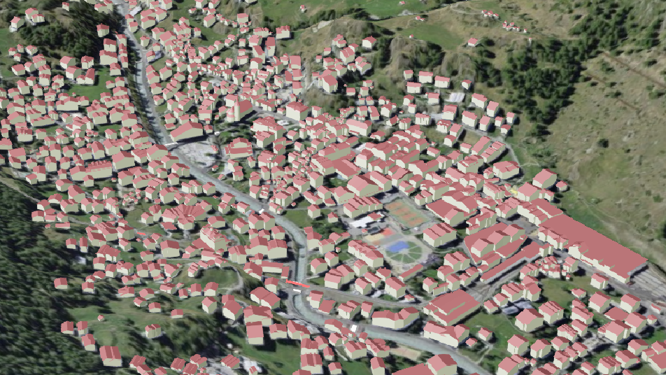
Darstellung einer Auswahl von natürlichen und künstlichen Objekten als dreidimensionale Elemente in der 3D-Umgebung des Geoportals des Bundes map.geo.admin.ch. Die Auswahl umfasst Gebäude, Brücken und Seilbahnen . Die Objekte stammen aus dem Topografischen Landschaftsmodell der Schweiz (TLM).
Sélection d'objets naturels et artificiels représentés comme des éléments tridimensionnels dans le mode 3D du géoportail fédéral map.geo.admin.ch. La sélection comporte les bâtiments, les ponts et les transports à câble. La sélection est tirée du modèle topographique du paysage de la Suisse (MTP).
Selezioni di oggetti naturali e artificiali rappresentati come elementi tridimensionali nella modalità 3D del geoportale federale map.geo.admin.ch. La selezione comprende edifici, ponti e funivie. La selezione è estratta dal modello topografico del paesaggio della Svizzera (MTP).
Selection of natural and artificial objects showed as tridimensional features in the 3D modus of the geoportal of the federal authorities of the Swiss Confederation map.geo.admin.ch. The selection contains buildings, bridges and cableways. The selection is based on the topographical landscape model of Switzerland (TLM).
Simple
-
Autre titreAltri nomi o acronimiAlternate titleAlternativtitel
-
Gebäude und Bauwerke
Bâtiments et constructions
Edifici e construzioni
Buildings and constructions
-
Date (Révision)Data (Revisione)Date (Revision)Datum (Aktualisierung)
- 2026-06-04
-
IdentifiantIdentificatoreIdentifierKennung
- ch.swisstopo.swissbuildings3d.3d
-
ÉtatStatoStatusBearbeitungsstatus
-
ContinuIn corsoOn goingKontinuierliche Aktualisierung
Point de contact
Punto di contatto
Point of contact
Ansprechpartner
-
Type de représentation spatialeTipo di rappresentazione spazialeSpatial representation typeRäumliche Darstellungsart
-
vecteurVettorialeVectorVektor
Résolution spatiale
Risoluzione spaziale
Spatial resolution
Räumliche Auflösung
Fraction représentative
Frazione rappresentativa
Equivalent scale
Vergleichsmassstab
-
DénominateurDenominatoreDenominatorMassstabszahl
- 5000
Résolution spatiale
Risoluzione spaziale
Spatial resolution
Räumliche Auflösung
Fraction représentative
Frazione rappresentativa
Equivalent scale
Vergleichsmassstab
-
DénominateurDenominatoreDenominatorMassstabszahl
- 25000
-
Catégorie de thèmeCategoria ISOTopic categoryThematik
-
-
A Imagerie, cartes de base et occupation du solA Mappe di base con immagini della copertura terrestreA Imagery base maps earth coverA Oberflächenbeschreibung
-
Étendue
Estensione
Extent
Ausdehnung
Étendue
Estensione
Extent
Ausdehnung
-
DescriptionDescrizioneDescriptionBeschreibung
-
Switzerland
Schweiz
Suisse
Svizzera
))

Étendue
Estensione
Extent
Ausdehnung
Étendue
Estensione
Extent
Ausdehnung
-
DescriptionDescrizioneDescriptionBeschreibung
-
Liechtenstein
Liechtenstein
Liechtenstein
Liechtenstein
))

-
Fréquence de mise à jourFrequenza di aggiornamentoMaintenance and update frequencyWartungsintervall
-
BiannuelleSemestraleBiannuallyHalbjährlich
- GEMET - INSPIRE themes, version 1.0
-
-
Réseaux de transport
Reti di trasporto
Transport networks
-
- GEMET - INSPIRE themes, version 1.0
-
-
Bâtiments
Edifici
Buildings
-
- GEMET
-
-
vecteur
vettore
vector
-
- geocat.ch
-
-
opendata.swiss
opendata.swiss
opendata.swiss
-
modèle du territoire
modello del territorio
landscape model
-
- geocat.ch
-
-
visualisation 3D
visualizzazione 3D
3D visualisation
-
IFDG l’Infrastructure Fédérale de données géographiques
IFDG Infrastruttura federale dei dati geografici
FSDI Federal Spatial Data Infrastructure
-
Contraintes sur la ressource
Vincoli sulle risorse
Resource constraints
Ressourcenbeschränkungen
-
Autres contraintesAltri vincoliOther constraintsAndere Einschränkungen
- Opendata BY: Freie Nutzung. Quellenangabe ist Pflicht.Opendata BY: Utilisation libre. Obligation d’indiquer la source.Opendata BY: Libero utilizzo. Indicazione della fonte obbligatoria.Opendata BY: Open use. Must provide the source.
Ressource associée
Risorsa associata
Associated resource
Verlinkte Ressource
-
Type d'associationTipo di associazioneAssociation TypeAssoziationstyp
-
Citation de travail plus largeCitazione di un'opera più ampiaReference to a master resource of which this one is a partÜbergeordneter Datenbestand
-
Metadata ReferenceRiferimento metadatiMetadata ReferenceMetadatenreferenz
Ressource associée
Risorsa associata
Associated resource
Verlinkte Ressource
-
TitreTitoloTitleTitel
-
Topografisches Landschaftsmodell (Landesvermessung)
Modèle topographique du paysage (mensuration nationale)
Modello topografico del paesaggio (misurazione nazionale)
-
Type d'associationTipo di associazioneAssociation TypeAssoziationstyp
-
Citation de travail plus largeCitazione di un'opera più ampiaReference to a master resource of which this one is a partÜbergeordneter Datenbestand
-
LangueLinguaLanguageSprache
- Deutsch
-
Encodage de caractèresCodifica dei caratteriCharacter encodingZeichenkodierung
-
Utf8UTF8UTF8Utf8
-
Catégorie de sous-thèmeCategoria di sottotemaSubtopic CategoryThematische Unterkategorien
-
A1 Cartes de base, modèles de paysageA1 Mappe di base, modelli paesaggisticiA1 Base Maps, Landscape ModelsA1 Basiskarten, Landschaftsmodelle
-
Géodonnées de baseGeodati di baseBasic GeodataGeobasisdaten
- true
-
Identifiant Géodonnées de baseIdentificativo dei geodati di baseBasic Geodata IDIdentifikator des Geobasisdatensatzes
-
38.1
-
Niveau des géodonnées de baseLivello legale dei geodati di baseBasic Geodata Legal LevelGeobasisdatenebene
-
FédéralFederaleFederalNational
-
Format de distributionFormato (codifica)Distribution formatAbgabeformat
-
-
3D Tiles
-
Options de transfert numérique
Opzioni di trasferimento digitale
Digital transfer options
Optionen für die digitale Übertragung
-
Ressource en ligneRisorsa onlineOnLine resourceOnline
-
map.geo.admin.ch preview
Options de transfert numérique
Opzioni di trasferimento digitale
Digital transfer options
Optionen für die digitale Übertragung
-
Ressource en ligneRisorsa onlineOnLine resourceOnline
-
3D Tiles Service
-
Nom du système de référenceNome del sistema di riferimentoReference system identifierName des Referenzsystems
- EPSG:4326
Metadata
-
Identifiant des métadonnéesIdentificativo della schedaMetadata identifierIdentifikator des Metadatensatzes
- 170010c1-5860-47c2-9a98-ec61668337fb
-
LangueLinguaLanguageSprache
- Deutsch
-
Encodage de caractèresCodifica dei caratteriCharacter encodingZeichenkodierung
-
Utf8UTF8UTF8Utf8
-
LangueLinguaLanguageSprache
- Français
-
Encodage de caractèresCodifica dei caratteriCharacter encodingZeichenkodierung
-
Utf8UTF8UTF8Utf8
-
LangueLinguaLanguageSprache
- Italiano
-
Encodage de caractèresCodifica dei caratteriCharacter encodingZeichenkodierung
-
Utf8UTF8UTF8Utf8
-
LangueLinguaLanguageSprache
- English
-
Encodage de caractèresCodifica dei caratteriCharacter encodingZeichenkodierung
-
Utf8UTF8UTF8Utf8
Point de contact
Punto di contatto
Point of contact
Ansprechpartner
-
Heures de serviceOrario di servizioHours of serviceBetriebszeiten
-
08h30 - 11h00 / 14h00 - 16h00 GMT+1
Type de ressource
Tipo di risorsa
Type of resource
Anwendungsbereich der Metadaten
-
Domaine d'application de la ressourceAmbito di applicazione della risorsaResource scopeDomäne der Ressourcenanwendung
-
Jeu de donnéesSet di datiDatasetDatenbestand
-
Informations de date (Création)Informazioni sulla data (Creazione)Date info (Creation)Datumsangaben (Erstellung)
- 2024-09-04T12:25:27.852Z
-
Informations de date (Révision)Informazioni sulla data (Revisione)Date info (Revision)Datumsangaben (Aktualisierung)
- 2026-06-04T08:56:45.636403Z
Norme des métadonnées
Standard dei metadati
Metadata standard
Metadatenstandard
-
TitreTitoloTitleTitel
-
eCH-0271