geocat.ch
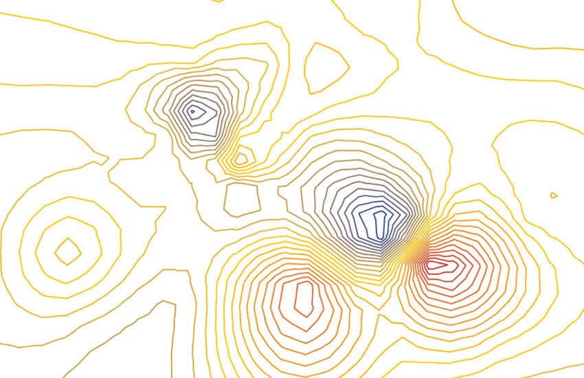
Total Intensity Map of Switzerland 1:500000
Geomagnetic maps are the result of measurements of total intensity, declination and inclination. The geomagnetic field is defined by a vector, which isrepresented in terms of its direction and intensity (nT). Because the Earth's magnetic field changes over time, the data in this map always relates to a specific time period. The values can be adapted using correction formulae which have experimentally determined. Paper map: G. Fischer & P.-A. Schnegg, 1979 (explanatory text on the back of the map). Vector map: 2001.
Simple
- Alternate title
-
Magnetic field strength 500
- Date (Publication)
- 1979-12-31
- Identifier
- ch.swisstopo.geologie-geophysik-totalintensitaet
- Purpose
-
Übersicht über die Magnetfeldstärke in der Schweiz
- Status
- Completed
Owner
- Spatial representation type
- paperMap
Spatial resolution
Equivalent scale
- Denominator
- 500000
- Topic category
-
- F Geoscientific information
Extent
Extent
- Description
-
National Map 1:500'000
- Geographic identifier
- NM500
))

- Maintenance and update frequency
- As needed
- Duration of Conservation
- 275
- Appraisal of Archival Value
- A
- Reason for Archiving Value
- Evidence of business practice
- geocat.ch
-
-
opendata.swiss
-
official geodata
-
Conservation and archiving planning AAP - Confederation
-
geophysical map
-
e-geo.ch
-
- GEMET
-
-
geophysics
-
magnetism
-
- geocat.ch
-
-
FSDI Federal Spatial Data Infrastructure
-
Associated resource
- Title
-
Geophysical maps
- Association Type
- Reference to a master resource of which this one is a part
- Language
- Deutsch
- Character encoding
- UTF8
- Language
- Français
- Character encoding
- UTF8
- Language
- Italiano
- Character encoding
- UTF8
- Language
- English
- Character encoding
- UTF8
- Subtopic Category
- F1 Geology
- Basic Geodata
- true
- Basic Geodata ID
-
47.3
- Basic Geodata Legal Level
- Federal
- Distribution format
-
-
ESRI Shapefile (SHP)
-
Digital transfer options
- OnLine resource
-
Vorschau map.geo.admin.ch
Preview map.geo.admin.ch
Digital transfer options
- OnLine resource
-
ch.swisstopo.geologie-geophysik-totalintensitaet
WMS-FSDI service, layer "Magnetic field strength 500"
Digital transfer options
- OnLine resource
-
ch.swisstopo.geologie-geophysik-totalintensitaet
WMTS-FSDI service, layer "Magnetic field strength 500"
Digital transfer options
Digital transfer options
Digital transfer options
Digital transfer options
- OnLine resource
-
RESTful API von geo.admin.ch
RESTful API from geo.admin.ch
- Statement
-
Diese Karte stellt vor dem Hintergrund der Landeskarte 1:500'000 und der Tektonischen Karte 1:500'000 die Totalintensität des Erdmagnetfeldes dar.
- Hierarchy level
- Dataset
- Reference system identifier
- Referenzsystem entsprechend der zugrundeliegenden topographischen Karte (CH1903)
Metadata
- Metadata identifier
- 132d9ff6-92de-4c02-87a7-72df26bcb33e
- Language
- Deutsch
- Character encoding
- UTF8
- Language
- Français
- Character encoding
- UTF8
- Language
- Italiano
- Character encoding
- UTF8
- Language
- English
- Character encoding
- UTF8
- Language
- Rumantsch
- Character encoding
- UTF8
Owner
Type of resource
- Resource scope
- Dataset
- Metadata linkage
-
https://www.geocat.ch/geonetwork/srv/api/records/132d9ff6-92de-4c02-87a7-72df26bcb33e
- Date info (Creation)
- 2012-08-14T09:48:04Z
- Date info (Revision)
- 2026-04-13T09:23:37.469113Z
Metadata standard
- Title
-
eCH-0271