geocat.ch
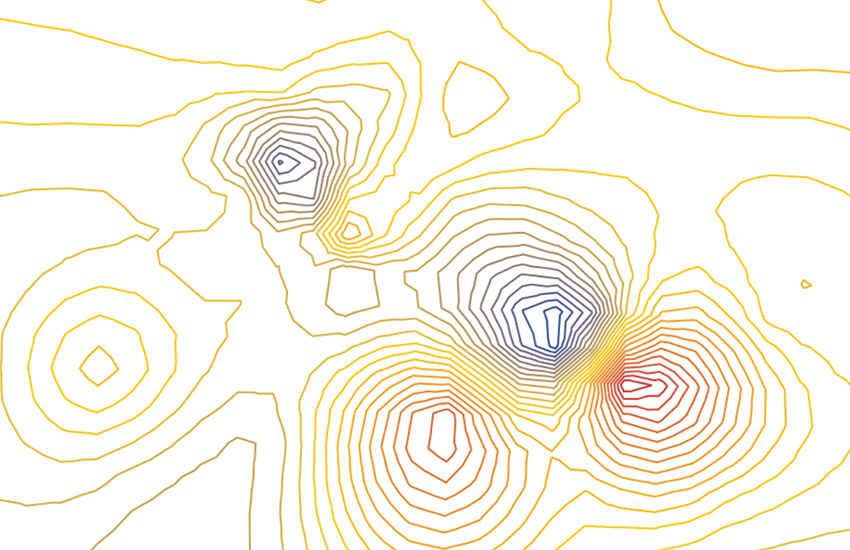
Totalintensitätskarte der Schweiz 1:500000
Carte de l’intensité totale en Suisse 1:500000
Carta dell'intensità totale in Svizzera 1:500000
Total Intensity Map of Switzerland 1:500000
Charta da l'intensitad totala en Svizra 1:500000
Die geomagnetischen Karten ergeben sich aus den Messungen der Totalintensität, der Deklination und der Inklination. Das geomagnetische Feld wird mittels eines Vektors definiert, der durch seine Direktion und Intensität (nT) dargestellt wurde. Da das Magnetfeld der Erde sich mit der Zeit ändert, beziehen sich die Angaben dieser Karten immer auf einen bestimmten Zeitabschnitt. Die Werte können mit Hilfe von Korrekturformeln, deren Koeffizienten experimentell bestimmt wurden, angepasst werden.- Papierkarte: G. FISCHER & P.-A. SCHNEGG, 1979 (Erläuterungstext auf der Kartenrückseite). - Vektorkarte: 2001.
Les cartes géomagnétiques découlent des mesures des éléments de l’intensité totale, de la déclinaison et de l’inclinaison. Le champ magnétique terrestre est défini à l’aide d’un vecteur représenté par sa direction et son intensité (nT). Du fait que le champ magnétique terrestre varie en fonction du temps les cartes géomagnétiques ne se réfèrent qu’à une époque donnée. Elles peuvent être adaptées à l’aide de formules correctives dont les coefficients sont déterminés expérimentalement.- Carte papier: G. FISCHER & P.-A. SCHNEGG, 1979 (Notice explicative au dos de la carte). - Carte vectorielle: 2001.
Le carte geomagnetiche sono ottenute dalle misurazioni dell'intensità totale, della declinazione e dell'inclinazione. Il campo magnetico terrestre viene definito con un vettore rappresentato attraverso la sua direzione e intensità (nT). Poiché il campo magnetico terrestre si modifica nel tempo, le indicazioni contenute in queste carte si riferiscono sempre a un determinato lasso di tempo. I valori possono essere adeguati con l'aiuto di formule correttive, i cui coefficienti sono stati determinati per via sperimentale. Carta in formato cartaceo: G. FISCHER & P.-A. SCHNEGG, 1979 (testo esplicativo sul retro della carta). - Carta vettoriale: 2001.
Geomagnetic maps are the result of measurements of total intensity, declination and inclination. The geomagnetic field is defined by a vector, which isrepresented in terms of its direction and intensity (nT). Because the Earth's magnetic field changes over time, the data in this map always relates to a specific time period. The values can be adapted using correction formulae which have experimentally determined. Paper map: G. Fischer & P.-A. Schnegg, 1979 (explanatory text on the back of the map). Vector map: 2001.
Las chartas geomagneticas resultan da las mesiraziuns da l'intensitad totala, da la declinaziun e da l'inclinaziun. Il champ geomagnetic vegn definì cun agid d'in vectur che vegn preschentà tras sia direcziun e sia intensitad (nT). Damai ch'il champ magnetic da la terra sa mida cun il temp, sa refereschan las indicaziuns da questas chartas adina ad ina tscherta perioda da temp. Las valurs pon vegnir adattadas cun agid da furmlas da correctura, da las qualas ils coeffizients èn vegnids calculads en experiments. – Charta da palpiri: G. FISCHER & P.-A. SCHNEGG, 1979 (text explicativ sin la vart davos da la charta). – Charta vectoriala: 2001.
Simple
-
Autre titreAltri nomi o acronimiAlternate titleAlternate titleAlternativtitel
-
Magnetfeldstärke 500
Intensité champ magnétique 500
Intensità campo magnetico 500
Magnetic field strength 500
Intensitad dal champ magnetic 500
-
Date (Publication)Data (Pubblicazione)Date (Publication)Date (Publication)Datum (Publikation)
- 1979-12-31
-
IdentifiantIdentificatoreIdentifierIdentifierKennung
- ch.swisstopo.geologie-geophysik-totalintensitaet
-
ButScopoPurposePurposeZweck
-
Übersicht über die Magnetfeldstärke in der Schweiz
Vue d'ensemble de l'intensité du champ magnétique en Suisse
-
ÉtatStatoStatusStatusBearbeitungsstatus
-
TerminéCompletatoCompletedCompletedAbgeschlossen
Propriétaire
Proprietario
Owner
Owner
Eigentümer
-
Type de représentation spatialeTipo di rappresentazione spazialeSpatial representation typeSpatial representation typeRäumliche Darstellungsart
-
paperMappaperMappaperMappaperMappaperMap
Résolution spatiale
Risoluzione spaziale
Spatial resolution
Spatial resolution
Räumliche Auflösung
Fraction représentative
Frazione rappresentativa
Equivalent scale
Equivalent scale
Vergleichsmassstab
-
DénominateurDenominatoreDenominatorDenominatorMassstabszahl
- 500000
-
Catégorie de thèmeCategoria ISOTopic categoryTopic categoryThematik
-
-
F Informations géoscientifiquesF Informazioni geoscientificheF Geoscientific informationF Geoscientific informationF Erdwissenschaften
-
Étendue
Estensione
Extent
Extent
Ausdehnung
Étendue
Estensione
Extent
Extent
Ausdehnung
-
DescriptionDescrizioneDescriptionDescriptionBeschreibung
-
National Map 1:500'000
Landeskarte 1:500'000
Carte nationale 1:500'000
Carta nazionale 1:500'000
Landeskarte 1:500'000
-
Identifiant géographiqueIdentificatore geograficoGeographic identifierGeographic identifierGeografische Kennung
- NM500LK500CN500CN500LK500
))

-
Fréquence de mise à jourFrequenza di aggiornamentoMaintenance and update frequencyMaintenance and update frequencyWartungsintervall
-
Comme nécessaireSecondo necessitàAs neededAs neededBei Bedarf
-
Durée de conservationDurata di conservazioneDuration of ConservationDuration of ConservationAufbewahrungsdauer NV in Jahren
- 275
-
Évaluation de la valeur archivistiqueValutazione del valore archivisticoAppraisal of Archival ValueAppraisal of Archival ValueBewertung Archivwürdigkeit
-
AAAAA
-
Raison de la valeur d'archivageMotivo del valore archivisticoReason for Archiving ValueReason for Archiving ValueBegründung Archivwürdigkeit
-
Preuve de la pratique couranteProva della pratica commercialeEvidence of business practiceEvidence of business practiceNachweis der Geschäftspraxis
- geocat.ch
-
-
opendata.swiss
opendata.swiss
opendata.swiss
opendata.swiss
-
géodonnées de base
geodati di base
official geodata
-
Planification de la conservation et de l'archivage AAP - Conféderation
Pianificazione della conservazione e dell’archiviazione AAP - Confederazione
Conservation and archiving planning AAP - Confederation
-
carte géophysique
carta geofisica
geophysical map
-
e-geo.ch
e-geo.ch
e-geo.ch
-
- GEMET
-
-
géophysique
geofisica
geophysics
-
magnétisme
magnetismo
magnetism
-
- GEMET - INSPIRE themes, version 1.0
-
-
Géologie
Geologia
Geology
-
- geocat.ch
-
-
BGDI Bundesgeodaten-Infrastruktur
IFDG l’Infrastructure Fédérale de données géographiques
IFDG Infrastruttura federale dei dati geografici
FSDI Federal Spatial Data Infrastructure
-
Ressource associée
Risorsa associata
Associated resource
Associated resource
Verlinkte Ressource
-
TitreTitoloTitleTitleTitel
-
Geophysikalisches Kartenwerk
Cartes géophysiques
Carte geofisiche
Geophysical maps
-
Type d'associationTipo di associazioneAssociation TypeAssociation TypeAssoziationstyp
-
Citation de travail plus largeCitazione di un'opera più ampiaReference to a master resource of which this one is a partReference to a master resource of which this one is a partÜbergeordneter Datenbestand
-
LangueLinguaLanguageLanguageSprache
- Deutsch
-
Encodage de caractèresCodifica dei caratteriCharacter encodingCharacter encodingZeichenkodierung
-
Utf8UTF8UTF8UTF8Utf8
-
LangueLinguaLanguageLanguageSprache
- Français
-
Encodage de caractèresCodifica dei caratteriCharacter encodingCharacter encodingZeichenkodierung
-
Utf8UTF8UTF8UTF8Utf8
-
LangueLinguaLanguageLanguageSprache
- Italiano
-
Encodage de caractèresCodifica dei caratteriCharacter encodingCharacter encodingZeichenkodierung
-
Utf8UTF8UTF8UTF8Utf8
-
LangueLinguaLanguageLanguageSprache
- English
-
Encodage de caractèresCodifica dei caratteriCharacter encodingCharacter encodingZeichenkodierung
-
Utf8UTF8UTF8UTF8Utf8
-
Catégorie de sous-thèmeCategoria di sottotemaSubtopic CategorySubtopic CategoryThematische Unterkategorien
-
F1 GéologieF1 GeologiaF1 GeologyF1 GeologyF1 Geologie
-
Géodonnées de baseGeodati di baseBasic GeodataBasic GeodataGeobasisdaten
- true
-
Identifiant Géodonnées de baseIdentificativo dei geodati di baseBasic Geodata IDBasic Geodata IDIdentifikator des Geobasisdatensatzes
-
47.3
-
Niveau des géodonnées de baseLivello legale dei geodati di baseBasic Geodata Legal LevelBasic Geodata Legal LevelGeobasisdatenebene
-
FédéralFederaleFederalFederalNational
-
Format de distributionFormato (codifica)Distribution formatDistribution formatAbgabeformat
-
-
ESRI Shapefile (SHP)
-
Options de transfert numérique
Opzioni di trasferimento digitale
Digital transfer options
Digital transfer options
Optionen für die digitale Übertragung
-
Ressource en ligneRisorsa onlineOnLine resourceOnLine resourceOnline
-
Vorschau map.geo.admin.ch
Vorschau map.geo.admin.chAperçu map.geo.admin.chPrevisione map.geo.admin.chPreview map.geo.admin.ch
Options de transfert numérique
Opzioni di trasferimento digitale
Digital transfer options
Digital transfer options
Optionen für die digitale Übertragung
-
Ressource en ligneRisorsa onlineOnLine resourceOnLine resourceOnline
-
ch.swisstopo.geologie-geophysik-totalintensitaet
WMS-BGDI Dienst, Layer "Magnetfeldstärke 500"Service WMS-IFDG, couche "Intensité champ magnétique 500"Servizio WMS-IFDG, strato "Intensità campo magnetico 500"WMS-FSDI service, layer "Magnetic field strength 500"WMS-BGDI Dienst, Layer "Magnetfeldstärke 500"
Options de transfert numérique
Opzioni di trasferimento digitale
Digital transfer options
Digital transfer options
Optionen für die digitale Übertragung
-
Ressource en ligneRisorsa onlineOnLine resourceOnLine resourceOnline
-
ch.swisstopo.geologie-geophysik-totalintensitaet
WMTS-BGDI Dienst, Layer "Magnetfeldstärke 500"Service WMTS-IFDG, couche , Layer "Intensité champ magnétique 500"Servizio WMTS-IFDG, strato "Intensità campo magnetico 500"WMTS-FSDI service, layer "Magnetic field strength 500"WMTS-BGDI Dienst, Layer "Magnetfeldstärke 500"
Options de transfert numérique
Opzioni di trasferimento digitale
Digital transfer options
Digital transfer options
Optionen für die digitale Übertragung
Options de transfert numérique
Opzioni di trasferimento digitale
Digital transfer options
Digital transfer options
Optionen für die digitale Übertragung
Options de transfert numérique
Opzioni di trasferimento digitale
Digital transfer options
Digital transfer options
Optionen für die digitale Übertragung
Options de transfert numérique
Opzioni di trasferimento digitale
Digital transfer options
Digital transfer options
Optionen für die digitale Übertragung
Options de transfert numérique
Opzioni di trasferimento digitale
Digital transfer options
Digital transfer options
Optionen für die digitale Übertragung
-
Ressource en ligneRisorsa onlineOnLine resourceOnLine resourceOnline
-
RESTful API von geo.admin.ch
RESTful API von geo.admin.chRESTful API de geo.admin.chRESTful API da geo.admin.chRESTful API from geo.admin.chRESTful API dad geo.admin.ch
-
Généralités sur la provenanceInformazioni generali sulla provenienzaStatementStatementErklärung
-
Diese Karte stellt vor dem Hintergrund der Landeskarte 1:500'000 und der Tektonischen Karte 1:500'000 die Totalintensität des Erdmagnetfeldes dar.
Cette carte représente l'intensité totale du champ magnétique terrestre sur le fond de la Carte nationale 1:500’000 et de la Carte tectonique 1:500’000.
-
NiveauLivelloHierarchy levelHierarchy levelBezugsebene
-
Jeu de donnéesSet di datiDatasetDatasetDatenbestand
-
Nom du système de référenceNome del sistema di riferimentoReference system identifierReference system identifierName des Referenzsystems
- Referenzsystem entsprechend der zugrundeliegenden topographischen Karte (CH1903)
Metadata
-
Identifiant des métadonnéesIdentificativo della schedaMetadata identifierMetadata identifierIdentifikator des Metadatensatzes
- 132d9ff6-92de-4c02-87a7-72df26bcb33e
-
LangueLinguaLanguageLanguageSprache
- Deutsch
-
Encodage de caractèresCodifica dei caratteriCharacter encodingCharacter encodingZeichenkodierung
-
Utf8UTF8UTF8UTF8Utf8
-
LangueLinguaLanguageLanguageSprache
- Français
-
Encodage de caractèresCodifica dei caratteriCharacter encodingCharacter encodingZeichenkodierung
-
Utf8UTF8UTF8UTF8Utf8
-
LangueLinguaLanguageLanguageSprache
- Italiano
-
Encodage de caractèresCodifica dei caratteriCharacter encodingCharacter encodingZeichenkodierung
-
Utf8UTF8UTF8UTF8Utf8
-
LangueLinguaLanguageLanguageSprache
- English
-
Encodage de caractèresCodifica dei caratteriCharacter encodingCharacter encodingZeichenkodierung
-
Utf8UTF8UTF8UTF8Utf8
-
LangueLinguaLanguageLanguageSprache
- Rumantsch
-
Encodage de caractèresCodifica dei caratteriCharacter encodingCharacter encodingZeichenkodierung
-
Utf8UTF8UTF8UTF8Utf8
Propriétaire
Proprietario
Owner
Owner
Eigentümer
Type de ressource
Tipo di risorsa
Type of resource
Type of resource
Anwendungsbereich der Metadaten
-
Domaine d'application de la ressourceAmbito di applicazione della risorsaResource scopeResource scopeDomäne der Ressourcenanwendung
-
Jeu de donnéesSet di datiDatasetDatasetDatenbestand
-
Lien vers la métadonnéeCollegamento ai metadatiMetadata linkageMetadata linkageLink zu den Metadaten
-
Informations de date (Création)Informazioni sulla data (Creazione)Date info (Creation)Date info (Creation)Datumsangaben (Erstellung)
- 2012-08-14T09:48:04Z
-
Informations de date (Révision)Informazioni sulla data (Revisione)Date info (Revision)Date info (Revision)Datumsangaben (Aktualisierung)
- 2026-04-13T09:23:37.469113Z
Norme des métadonnées
Standard dei metadati
Metadata standard
Metadata standard
Metadatenstandard
-
TitreTitoloTitleTitleTitel
-
eCH-0271