geocat.ch
Nutzungsplanung (kantonal / kommunal)
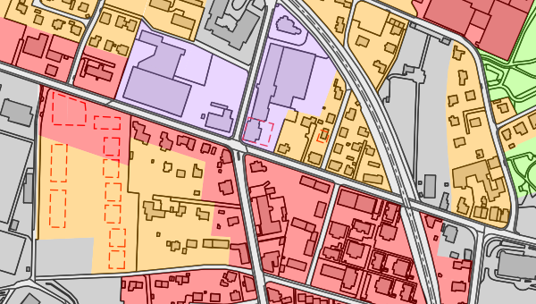
In den Nutzungsplänen (häufig auch als Zonenpläne bezeichnet) wird die Art der Bodennutzung geregelt. Sie unterteilen das Gebiet in verschiedene Bau-, Landwirtschafts- oder Schutzzonen. Über sie wird in der Regel auf Stufe Gemeinde entschieden, gefolgt von der Genehmigung durch eine kantonale Behörde. Diese Genehmigung verleiht den Nutzungsplänen eine bindende Wirkung. Die Daten basieren auf dem MGDM Nutzungsplanung (ID 73.1, Version 1.2).
Simple
- Date (Creation)
- 2017-11-01
Resource provider
- Topic category
-
- E Planning cadastre
Extent
Extent
- Description
-
Switzerland
))

- Maintenance and update frequency
- Daily
- geocat.ch
-
-
land use planning
-
canton
-
official geodata
-
minimum geodata model MGDM
-
geodienste.ch
-
- GEMET
-
-
physical planning
-
federal law
-
- Language
- Deutsch
- Character encoding
- UTF8
- Subtopic Category
- E1 Spatial Planning, Spatial Development
- Basic Geodata
- true
- Basic Geodata ID
-
73.1
- Basic Geodata Legal Level
- Federal
- Distribution format
-
-
STAC
-
OGC Web Map Service (WMS)
-
OGC Web Feature Service (WFS)
-
OGC Geopackage (GPKG)
-
ESRI Shapefile (SHP)
-
Digital transfer options
- OnLine resource
-
Dokumentation
Report on the implementation of services, data, and attributes.
Digital transfer options
- OnLine resource
-
Daten
WMS
Digital transfer options
- OnLine resource
-
Datenbezug
Data access
Digital transfer options
- OnLine resource
-
STAC
STAC
- Reference system identifier
- EPSG:2056
Metadata
- Metadata identifier
- 0ed344a4-504a-4126-8f69-43d8fdcbd005
- Language
- Deutsch
- Character encoding
- UTF8
- Language
- Français
- Character encoding
- UTF8
- Language
- Italiano
- Character encoding
- UTF8
- Language
- English
- Character encoding
- UTF8
Resource provider
Type of resource
- Resource scope
- Dataset
- Metadata linkage
-
https://www.geocat.ch/geonetwork/srv/api/records/0ed344a4-504a-4126-8f69-43d8fdcbd005
- Date info (Creation)
- 2017-11-01T00:00:00.000Z
- Date info (Revision)
- 2026-06-20T23:03:22.312373Z
Metadata standard
- Title
-
GM03_2