 geocat.ch
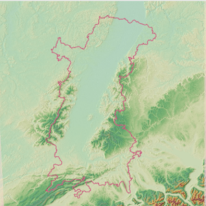
Relief - Modèle numérique de terrain (MNT) du Rhin Supérieur
Relief - Digitale Geländemodell (DGM) des Oberrheins
Relief - Digital Elevation Model (DEM) of the Upper Rhine
Cette donnée décrit le relief à travers une image constituée de pixels faisant 25x25m. Ce modèle numérique de terrain maillé fourni, pour chaque pixel, une valeur d'altitude. La donnée provient d'un découpage sur la région du Rhin Supérieur du produit fourni par le service Copernicus de surveillance des terres (CLMS).
Diese Daten beschreiben das Relief durch ein Bild, das aus 25x25m großen Pixeln besteht. Dieses vermaschte digitale Geländemodell liefert für jeden Pixel einen Höhenwert. Die Daten stammen aus dem Produkt des Copernicus Land Monitoring Service (CLMS), das auf die Oberrheinregion zugeschnitten ist.
This data describes the relief through an image made of pixels measuring 25x25m. This digital terrain model provides, for each pixel, an altitude value. The data comes from a clipping over the Upper Rhine region of the product provided by the Copernicus Land Monitoring Service (CLMS).
Simple
-
AlternativtitelAlternate titleAutre titre
-
MNT
DGM
DEM
-
Datum (Erstellung)Date (Creation)Date (Création)
- 2021-11-10
-
Datum (Publikation)Date (Publication)Date (Publication)
- 2021-12-14
-
KennungIdentifierIdentifiant
- mnt_dgm
-
BearbeitungsstatusStatusÉtat
-
AbgeschlossenCompletedTerminé
Kontakt für die Ressource
Point of contact
Contact pour la ressource
-
mri:deliveryPointmri:deliveryPointmri:deliveryPoint
-
100, avenue d'Alsace
100, avenue d'Alsace
-
mri:citymri:citymri:city
-
COLMAR
-
mri:postalCodemri:postalCodemri:postalCode
-
68000
-
mri:countryCountrymri:country
-
FRANCE
FRANCE
-
mri:electronicMailAddressmri:electronicMailAddressmri:electronicMailAddress
-
GeoRhena
GeoRhena
GeoRhena
-
Räumliche DarstellungsartSpatial representation typeType de représentation spatiale
-
VektorVectorvecteur
Räumliche Auflösung
Spatial resolution
Résolution spatiale
Vergleichsmassstab
Equivalent scale
Fraction représentative
-
MassstabszahlDenominatorDénominateur
- 5000
-
ThematikTopic categoryCatégorie de thème
-
-
C HöhenangabenC ElevationC Élévation
-
A OberflächenbeschreibungA Imagery base maps earth coverA Imagerie, cartes de base et occupation du sol
-
Ausdehnung
Extent
Étendue
Ausdehnung
Extent
Étendue
Zeitlicher Umfang
Temporal extent
Étendue temporelle
-
ZeitraumTime periodPériode
- 2011-01-01 2011-12-31
Ausdehnung
Extent
Étendue
Ausdehnung
Extent
Étendue
))
-
WartungsintervallMaintenance and update frequencyFréquence de mise à jour
-
Nicht geplantNot plannedNon planifiée
- Keywords
-
-
Données ouvertes
Open-Data
Open-Data
-
Relief
Relief
Relief
-
- Keywords
-
-
Rhin Supérieur
Oberrhein
Upper Rhine
-
- GEMET - Concepts, version 2.4
-
-
altitude
Höhe
altitude
-
relief
Relief
relief (land)
-
Ressourcenbeschränkungen
Resource constraints
Contraintes sur la ressource
-
NutzungsbeschränkungUse limitationLimitation d'utilisation
-
Licence CC BY - © European Union, Copernicus Land Monitoring Service 2018, European Environment Agency (EEA)
Licence CC BY - © European Union, Copernicus Land Monitoring Service 2018, European Environment Agency (EEA)
Licence CC BY - © European Union, Copernicus Land Monitoring Service 2018, European Environment Agency (EEA)
Ressourcenbeschränkungen
Resource constraints
Contraintes sur la ressource
-
ZugriffsbeschränkungenAccess constraintsContraintes d'accès
-
Andere BeschränkungenOther restrictionsAutres restrictions
-
NutzungseinschränkungenUse constraintsContraintes d'utilisation
-
Andere BeschränkungenOther restrictionsAutres restrictions
-
Andere EinschränkungenOther constraintsAutres contraintes
-
Pas d'autre limitation
Keine andere Einschränkung
No other limitation
-
SpracheLanguageLangue
- Français
-
ZeichenkodierungCharacter encodingEncodage de caractères
-
Utf8UTF8Utf8
-
AbgabeformatDistribution formatFormat de distribution
-
-
Géodonnée au format TIF
GeoDatei im TIF
TIF GeoData
-
Optionen für die digitale Übertragung
Digital transfer options
Options de transfert numérique
-
OnlineOnLine resourceRessource en ligne
-
mnt_dem
Modèle numérique de terrain / Digitales Geländemodell
Optionen für die digitale Übertragung
Digital transfer options
Options de transfert numérique
-
OnlineOnLine resourceRessource en ligne
-
Site internet du programme Copernicus
Website des Copernicus-Programms
Copernicus programme website
Informations sur les données sourcesInformationen zu den QuelldatenInformation on source data
-
ErklärungStatementGénéralités sur la provenance
-
Découpage réalisée sur le produit EU-DEM v1.1 (programme Copernicus)
Ausschnitt erstellt auf dem Produkt EU-DEM v1.1 (Copernicus Programm)
Trimming performed on the EU-DEM v1.1 product (Copernicus programme)
-
BezugsebeneHierarchy levelNiveau
-
DatenbestandDatasetJeu de données
Metadata
-
Identifikator des MetadatensatzesMetadata identifierIdentifiant des métadonnées
- 0dfbcf14-2f1e-4a2d-b186-6c532a00f9f2
-
SpracheLanguageLangue
- Français
-
ZeichenkodierungCharacter encodingEncodage de caractères
-
Utf8UTF8Utf8
-
SpracheLanguageLangue
- Deutsch
-
ZeichenkodierungCharacter encodingEncodage de caractères
-
Utf8UTF8Utf8
-
SpracheLanguageLangue
- English
-
ZeichenkodierungCharacter encodingEncodage de caractères
-
Utf8UTF8Utf8
Kontaktstelle für Metadaten
Contact
Point de contact des métadonnées
Anwendungsbereich der Metadaten
Type of resource
Type de ressource
-
Domäne der RessourcenanwendungResource scopeDomaine d'application de la ressource
-
DatenbestandDatasetJeu de données
-
Datumsangaben (Aktualisierung)Date info (Revision)Informations de date (Révision)
- 2025-06-18T15:08:38.601463Z
Metadatenstandard
Metadata standard
Norme des métadonnées
-
TitelTitleTitre
-
ISO 19115-3:2018
-
AusgabeEditionÉdition
-
1.0
)))