geocat.ch
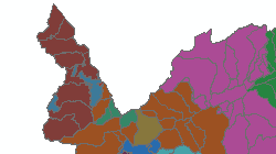
Energie - Zones de desserte
Zones de desserte des gestionnaires de réseau de distribution électrique
• Niveau de réseau 5: >1 kV à 36 kV
• Niveau de réseau 7: 0.4 kV à 1 kV
Simple
- Alternate title
-
Zones de desserte
- Date (Creation)
- 2019-03-25
- Date (Revision)
- 2024-01-03
- Identifier
- 499
- Purpose
-
Désignation et attribution des zones de desserte
- Status
- On going
Custodian
- Spatial representation type
- Vector
Spatial resolution
Equivalent scale
- Denominator
- 25000
- Topic category
-
- Q Utilities communication
Extent
Extent
- Description
-
Canton of Valais (VS)
))

- Maintenance and update frequency
- As needed
- Maintenance note
-
Pas systématique, selon les besoins du service
Resource format
- Title
-
ESRI Enterprise Geodatabase
- Date
- GEMET
-
-
energy
-
- GEMET - INSPIRE themes, version 1.0
-
-
Transport networks
-
- GEMET
-
-
electricity
-
- geocat.ch
-
-
official geodata
-
Resource constraints
- Use limitation
-
aucune
Resource constraints
- Access constraints
- Other restrictions
- Other constraints
-
Géodonnées accessibles au public (niveau A selon l'OGéo)
- Other constraints
-
Les conditions générales d'utilisation des géodonnées du Canton du Valais font foi ( https://www.vs.ch/fr/web/guest/information-legale).
Associated resource
- Association Type
- Reference from one resource to another
- Metadata Reference
- Language
- Français
- Character encoding
- UTF8
- Environment description
-
S:\Géodonnées VS\Q1 Energie\Zones de desserte.lyr
- Subtopic Category
- Q1 Energy
- Basic Geodata
- true
- Basic Geodata ID
-
183>A.1
- Basic Geodata Legal Level
- Cantonal
- Basic Geodata Type
- basicGeodata
- Distribution format
-
-
ESRI Shapefile (SHP)
-
autres formats sur demande / andere Formate auf Anfrage
-
ArcGIS REST Feature Service
-
Distributor
Digital transfer options
- OnLine resource
-
Géoportail du Canton du Valais
Géoportail du Canton du Valais
Digital transfer options
- OnLine resource
-
zones_dessertes/Niveau5
Zones de desserte de niveau 5 du Canton du Valais
Digital transfer options
- OnLine resource
-
zones_dessertes/Niveau7
Zones de desserte de niveau 7 du Canton du Valais
- Statement
-
Information des distributeurs
- Hierarchy level
- Dataset
- Description
-
Saisie suivant information des distributeurs
- Geometric object type
- Surface
- Geometric object count
- 655
- Reference system identifier
- EPSG: 2056/CH1903+_MN95
Metadata
- Metadata identifier
- 0d1864c1-b262-47ca-b9ea-e3f76f220b3e
- Language
- Français
- Character encoding
- UTF8
- Language
- Deutsch
- Character encoding
- UTF8
- Language
- Italiano
- Character encoding
- UTF8
- Language
- English
- Character encoding
- UTF8
- Language
- Rumantsch
- Character encoding
- UTF8
Distributor
Type of resource
- Resource scope
- Dataset
- Metadata linkage
-
https://www.geocat.ch/geonetwork/srv/api/records/0d1864c1-b262-47ca-b9ea-e3f76f220b3e
- Date info (Creation)
- 2019-04-05T10:34:57Z
- Date info (Revision)
- 2026-04-13T09:25:12.475025Z
Metadata standard
- Title
-
eCH-0271