geocat.ch
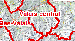
Arrondissements de construction et d'entretien routier
Découpage du territoire en 3 arrondissements de construction et d'entretien routier : arrondissement 1, Haut-Valais; arrondissement 2, Valais central; arrondissement 3, Bas-Valais
Simple
- Alternate title
-
Arrondissements
- Date (Creation)
- 1990-01-01
- Date (Revision)
- 2026-03-12
- Identifier
- 187
- Purpose
-
Gestion des travaux de construction et d'entretien
- Status
- On going
Custodian
- Spatial representation type
- Vector
Spatial resolution
Equivalent scale
- Denominator
- 10000
- Topic category
-
- P Transportation
Extent
Extent
- Description
-
Canton of Valais (VS)
))

- Maintenance and update frequency
- Annually
Resource format
- Title
-
ESRI Enterprise Geodatabase
- Date
- GEMET - INSPIRE themes, version 1.0
-
-
Area management/restriction/regulation zones and reporting units
-
- GEMET
-
-
road maintenance
-
- geocat.ch
-
-
opendata.swiss
-
Resource constraints
- Use limitation
-
Aucune
Resource constraints
- Access constraints
- Other restrictions
- Other constraints
-
Les conditions générales d'utilisation des géodonnées du Canton du Valais font foi ( https://www.vs.ch/fr/web/guest/information-legale).
- Language
- Français
- Character encoding
- UTF8
- Language
- Deutsch
- Character encoding
- UTF8
- Environment description
-
S:\Géodonnées VS\P Transport\Arrondissements.lyr
- Included with dataset
- true
- Title
-
Structure - Arrondissements
- Date (Creation)
- 2016-06-20
- Distribution format
-
-
ESRI Shapefile (SHP)
-
OGC Web Map Service (WMS)
-
ArcGIS REST Feature Service
-
Distributor
Digital transfer options
- OnLine resource
-
Géoportail du Canton du Valais
Géoportail du Canton du Valais
Digital transfer options
- OnLine resource
-
OpenData Valais
OpenData Valais - Site de téléchargement de géodonnées à l'Etat du Valais : multiformat et WebMercator
Digital transfer options
- OnLine resource
-
Landing Page
Landing Page pour opendata
Digital transfer options
- OnLine resource
-
Permalink opendata.swiss
Permalink opendata.swiss
Digital transfer options
- OnLine resource
Digital transfer options
- OnLine resource
-
1
Arrondissements
Digital transfer options
- OnLine resource
-
VS_M_Arrondissement
Arrondissement
- Statement
-
Organisation interne du SDM
- Hierarchy level
- Dataset
- Description
-
Agrégation de la surface des communes
- Geometric object type
- Surface
- Geometric object count
- 3
- Reference system identifier
- EPSG:2056/CH1903+_MN95
Metadata
- Metadata identifier
- 0c139184-2fa5-46cf-9ccd-99a3e5360fdc
- Language
- Français
- Character encoding
- UTF8
- Language
- Deutsch
- Character encoding
- UTF8
- Language
- Italiano
- Character encoding
- UTF8
- Language
- English
- Character encoding
- UTF8
- Language
- Rumantsch
- Character encoding
- UTF8
Distributor
Type of resource
- Resource scope
- Dataset
- Metadata linkage
-
https://www.geocat.ch/geonetwork/srv/api/records/0c139184-2fa5-46cf-9ccd-99a3e5360fdc
- Date info (Creation)
- 2014-12-16T17:15:50Z
- Date info (Revision)
- 2026-04-13T09:17:33.923734Z
Metadata standard
- Title
-
eCH-0271